Turn on suggestions
Auto-suggest helps you quickly narrow down your search results by suggesting possible matches as you type.
Cancel
- Home
- :
- All Communities
- :
- Products
- :
- Data Management
- :
- Data Management Questions
- :
- Projecting multiple images from one coordinate sys...
Options
- Subscribe to RSS Feed
- Mark Topic as New
- Mark Topic as Read
- Float this Topic for Current User
- Bookmark
- Subscribe
- Mute
- Printer Friendly Page
Projecting multiple images from one coordinate system to another,
Subscribe
by
Anonymous User
Not applicable
09-26-2013
10:42 AM
- Mark as New
- Bookmark
- Subscribe
- Mute
- Subscribe to RSS Feed
- Permalink
Original User: Jamal432@gmail.com
Projecting multiple images from one coordinate system to another,
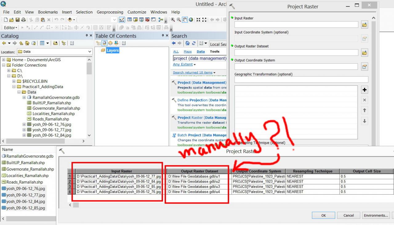
I wanted to project multiple Jpeg images form Israel to Palestine coordinate system using the batch of the ???project raster??? tool but couldn???t figure out how the input raster are populated automatically in the ???output raster dataset???
[ATTACH=CONFIG]27794[/ATTACH], [ATTACH=CONFIG]27795[/ATTACH]
Is there a way to populate the images automatically in the ???output raster dataset????
Thank you
Best
Jamal
Projecting multiple images from one coordinate system to another,
I wanted to project multiple Jpeg images form Israel to Palestine coordinate system using the batch of the ???project raster??? tool but couldn???t figure out how the input raster are populated automatically in the ???output raster dataset???
[ATTACH=CONFIG]27794[/ATTACH], [ATTACH=CONFIG]27795[/ATTACH]
Is there a way to populate the images automatically in the ???output raster dataset????
Thank you
Best
Jamal
Solved! Go to Solution.
1 Solution
Accepted Solutions
by
Anonymous User
Not applicable
09-26-2013
11:44 AM
- Mark as New
- Bookmark
- Subscribe
- Mute
- Subscribe to RSS Feed
- Permalink
Original User: JSkinn3
Hi Jamal,
I don't believe there is a way to auto populate this parameter. You can easily accomplish this in python, though. Here is an example:
The above code will iterate through the 'D:\Practical1_AddingData\Data' directory and reproject each JPG to a new JPG with the same name, just with "_project" added to it.
Hi Jamal,
I don't believe there is a way to auto populate this parameter. You can easily accomplish this in python, though. Here is an example:
import arcpy
from arcpy import env
env.workspace = r"D:\Practical1_AddingData\Data"

for raster in arcpy.ListRasters("*.jpg"):
    arcpy.ProjectRaster_management(raster, raster + "_project.jpg", "GEOGCS['GCS_Palestine_1923',DATUM['D_Palestine_1923',SPHEROID['Clarke_1880_Benoit',6378300.789,293.4663155389802]],PRIMEM['Greenwich',0.0],UNIT['Degree',0.0174532925199433]]","NEAREST","0.0000025","Palestine_1923_To_Israel_1","#","GEOGCS['GCS_Israel',DATUM['D_Israel',SPHEROID['GRS_1980',6378137.0,298.257222101]],PRIMEM['Greenwich',0.0],UNIT['Degree',0.0174532925199433]]")
The above code will iterate through the 'D:\Practical1_AddingData\Data' directory and reproject each JPG to a new JPG with the same name, just with "_project" added to it.
11 Replies
by
Anonymous User
Not applicable
09-26-2013
11:44 AM
- Mark as New
- Bookmark
- Subscribe
- Mute
- Subscribe to RSS Feed
- Permalink
Original User: JSkinn3
Hi Jamal,
I don't believe there is a way to auto populate this parameter. You can easily accomplish this in python, though. Here is an example:
The above code will iterate through the 'D:\Practical1_AddingData\Data' directory and reproject each JPG to a new JPG with the same name, just with "_project" added to it.
Hi Jamal,
I don't believe there is a way to auto populate this parameter. You can easily accomplish this in python, though. Here is an example:
import arcpy from arcpy import env env.workspace = r"D:\Practical1_AddingData\Data" for raster in arcpy.ListRasters("*.jpg"): arcpy.ProjectRaster_management(raster, raster + "_project.jpg", "GEOGCS['GCS_Palestine_1923',DATUM['D_Palestine_1923',SPHEROID['Clarke_1880_Benoit',6378300.789,293.4663155389802]],PRIMEM['Greenwich',0.0],UNIT['Degree',0.0174532925199433]]","NEAREST","0.0000025","Palestine_1923_To_Israel_1","#","GEOGCS['GCS_Israel',DATUM['D_Israel',SPHEROID['GRS_1980',6378137.0,298.257222101]],PRIMEM['Greenwich',0.0],UNIT['Degree',0.0174532925199433]]")The above code will iterate through the 'D:\Practical1_AddingData\Data' directory and reproject each JPG to a new JPG with the same name, just with "_project" added to it.
09-26-2013
12:57 PM
- Mark as New
- Bookmark
- Subscribe
- Mute
- Subscribe to RSS Feed
- Permalink
Hi Jamal,
I don't believe there is a way to auto populate this parameter. You can easily accomplish this in python, though. Here is an example:import arcpy from arcpy import env env.workspace = r"D:\Practical1_AddingData\Data" for raster in arcpy.ListRasters("*.jpg"): arcpy.ProjectRaster_management(raster, raster + "_project.jpg", "GEOGCS['GCS_Palestine_1923',DATUM['D_Palestine_1923',SPHEROID['Clarke_1880_Benoit',6378300.789,293.4663155389802]],PRIMEM['Greenwich',0.0],UNIT['Degree',0.0174532925199433]]","NEAREST","0.0000025","Palestine_1923_To_Israel_1","#","GEOGCS['GCS_Israel',DATUM['D_Israel',SPHEROID['GRS_1980',6378137.0,298.257222101]],PRIMEM['Greenwich',0.0],UNIT['Degree',0.0174532925199433]]")
The above code will iterate through the 'D:\Practical1_AddingData\Data' directory and reproject each JPG to a new JPG with the same name, just with "_project" added to it.
Many thanks Jake for the help,
Sorry but I couldn�??t know how to integrate the code you have provided with the �??project raster�?� tool. Could you please elaborate a bit more.
[ATTACH=CONFIG]27804[/ATTACH]
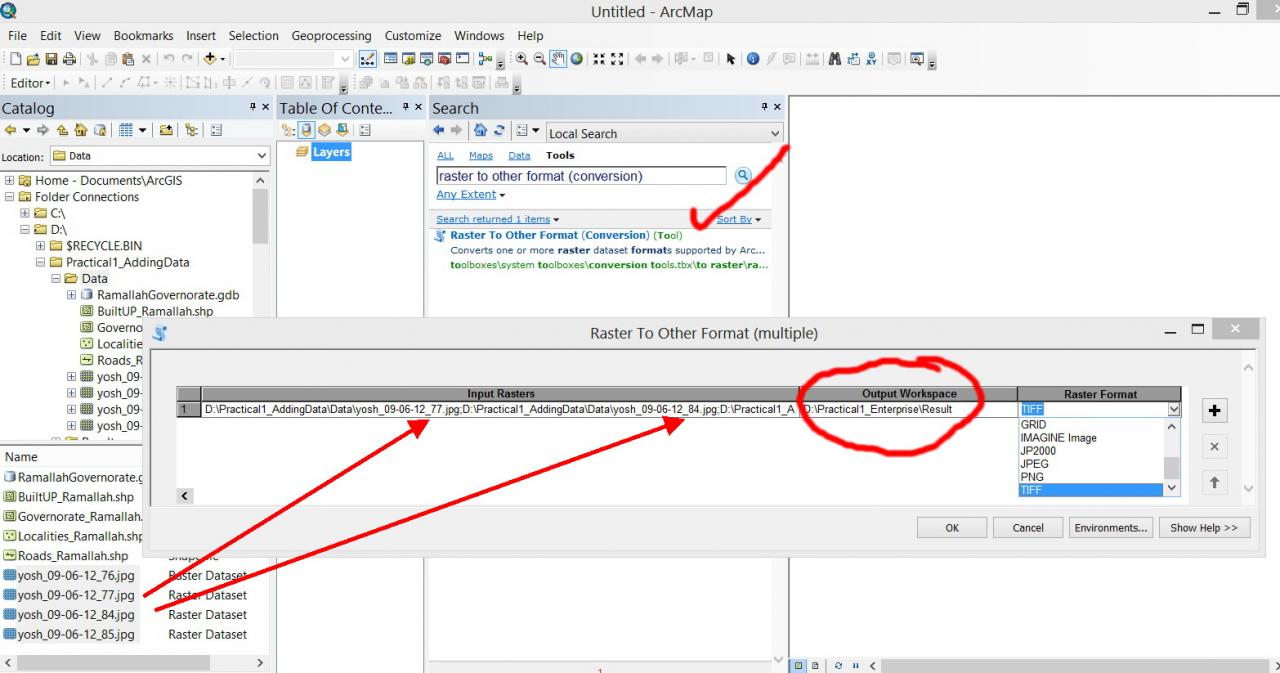
By the way, I like the behavior of the �??raster to other format�?� tool where the output is populated automatically in the specified folder. Why the design of the �??project raster�?� is not developed to be the same as �??raster to other format�?�?
[ATTACH=CONFIG]27805[/ATTACH]
Best
Jamal
----------------------------------------
Jamal Numan
Geomolg Geoportal for Spatial Information
Ramallah, West Bank, Palestine
Jamal Numan
Geomolg Geoportal for Spatial Information
Ramallah, West Bank, Palestine
by
Anonymous User
Not applicable
09-27-2013
03:13 AM
- Mark as New
- Bookmark
- Subscribe
- Mute
- Subscribe to RSS Feed
- Permalink
Original User: JSkinn3
Open your python window in ArcMap and you can copy/paste the code in there.
The code will iterate through your 'D:\Practical1_Adding\Data directory and reproject each JPG. It will write the new projected raster to the same directory with the same name plus "_project" added to it. For example, the image 'yosh_09-06-12_77.jpg' will be reprojected and named 'yosh_09-06-12_77_project.jpg'.
09-27-2013
07:03 AM
- Mark as New
- Bookmark
- Subscribe
- Mute
- Subscribe to RSS Feed
- Permalink
Open your python window in ArcMap and you can copy/paste the code in there.
The code will iterate through your 'D:\Practical1_Adding\Data directory and reproject each JPG. It will write the new projected raster to the same directory with the same name plus "_project" added to it. For example, the image 'yosh_09-06-12_77.jpg' will be reprojected and named 'yosh_09-06-12_77_project.jpg'.
Thank you Jake very much for the prompt help. It works fantastically.
While the code you have already sent is great in its current form, I still couldn�??t figure out why the behavior of the �??project raster�?� can�??t be developed to be the same as �??raster to other format�?� such that multiple projected raster can be populated automatically in the specified folder.
[ATTACH=CONFIG]27818[/ATTACH]
Meanwhile, how the coded you have already sent can be further developed to allow the user to specify the input and output of raster (on the hard drive)?
Is it also possible to be developed in form of script tool?
[ATTACH=CONFIG]27819[/ATTACH]
----------------------------------------
Jamal Numan
Geomolg Geoportal for Spatial Information
Ramallah, West Bank, Palestine
Jamal Numan
Geomolg Geoportal for Spatial Information
Ramallah, West Bank, Palestine
by
Anonymous User
Not applicable
01-15-2014
12:26 AM
- Mark as New
- Bookmark
- Subscribe
- Mute
- Subscribe to RSS Feed
- Permalink
Original User: prabinrokaya@gmail.com
Can anyone tell me how can I project thousands of bil images into WGS_1984_UTM_Zone_37N?
Can anyone tell me how can I project thousands of bil images into WGS_1984_UTM_Zone_37N?
01-16-2014
01:27 AM
- Mark as New
- Bookmark
- Subscribe
- Mute
- Subscribe to RSS Feed
- Permalink
Are all of your bil files correctly georeferenced and on the WGS84 datum?
If so, follow the code template given by Jake above.
The WKID for WGS_1984_UTM_Zone_37N is 32637, so, rather than listing the entire text for the projection, I would use the WKID to create a spatial reference object for use in the Project function.
Thus :
See the examples here :
http://resources.arcgis.com/en/help/main/10.2/#/Project_Raster/00170000007q000000/
Cheers and good luck,
Neil
If so, follow the code template given by Jake above.
The WKID for WGS_1984_UTM_Zone_37N is 32637, so, rather than listing the entire text for the projection, I would use the WKID to create a spatial reference object for use in the Project function.
Thus :
import arcpy
from arcpy import env
env.workspace = r"Your path to the data here"

srOut = arcpy.SpatialReference(32637)


for raster in arcpy.ListRasters("*.bil"):
    arcpy.ProjectRaster_management(raster, raster + "_project.bil", srOut)
See the examples here :
http://resources.arcgis.com/en/help/main/10.2/#/Project_Raster/00170000007q000000/
Cheers and good luck,
Neil
by
Anonymous User
Not applicable
01-16-2014
12:19 PM
- Mark as New
- Bookmark
- Subscribe
- Mute
- Subscribe to RSS Feed
- Permalink
Original User: prabinrokaya@gmail.com
Thank you Neil for the assistance. It was really kind of you. But yes, the bil files are not correctly geo-referenced. I also tried to do it via model builder but because file are not properly geo-referenced, it was difficult. Actually I have precipitation images which I want to first geo-referenced (usually I do it via arccatalog, going to spatial reference, edit and selecting GCS WGS 1984) and then through data management tool, project raster, I project them into WGS_1984_UTM_Zone_37N. Then in ArcGIS, I use extract by mask tool to get precipitation map for only my watershed. And calculate value using raster calculator. But the problem I have is, I have thousands of images and I can not do it manually. I wanted to do it via model builder or python and I am looking for assistance as all my attempts to figure it out have failed. It would be really really grateful if you could help me.
Thank you for your time and consideration.
Prabin Rokaya
MSC, UNESCO-IHE Institute for Water Education
Are all of your bil files correctly georeferenced and on the WGS84 datum?
If so, follow the code template given by Jake above.
The WKID for WGS_1984_UTM_Zone_37N is 32637, so, rather than listing the entire text for the projection, I would use the WKID to create a spatial reference object for use in the Project function.
Thus :import arcpy from arcpy import env env.workspace = r"Your path to the data here" srOut = arcpy.SpatialReference(32637) for raster in arcpy.ListRasters("*.bil"): arcpy.ProjectRaster_management(raster, raster + "_project.bil", srOut)
See the examples here :
http://resources.arcgis.com/en/help/main/10.2/#/Project_Raster/00170000007q000000/
Cheers and good luck,
Neil
01-17-2014
04:39 AM
- Mark as New
- Bookmark
- Subscribe
- Mute
- Subscribe to RSS Feed
- Permalink
Prabin,
errr...
If the original bil images are not georeferenced then no amount of assigning a coordinate system / projecting and what not is going to help.
They are simply not georeferenced. You will have to go through a georeferencing step which involves picking control points from the image and assigning to these points their correct coordinates.
But that is rather odd, where did this raster data come from?
Neil
by
Anonymous User
Not applicable
01-17-2014
10:08 AM
- Mark as New
- Bookmark
- Subscribe
- Mute
- Subscribe to RSS Feed
- Permalink
Original User: Jamal432@gmail.com
Hi Neil,
I�??m not sure if this code can be developed in form of geoprocessing tool. This would be much more easier for the end users. This command is a need for everybody
Also, I would like to point out that the code originally provided by Jake includes all parameters required for the projection.
Best
Jamal
Thank you Neil for the assistance. It was really kind of you. But yes, the bil files are not correctly geo-referenced. I also tried to do it via model builder but because file are not properly geo-referenced, it was difficult. Actually I have precipitation images which I want to first geo-referenced (usually I do it via arccatalog, going to spatial reference, edit and selecting GCS WGS 1984) and then through data management tool, project raster, I project them into WGS_1984_UTM_Zone_37N. Then in ArcGIS, I use extract by mask tool to get precipitation map for only my watershed. And calculate value using raster calculator. But the problem I have is, I have thousands of images and I can not do it manually. I wanted to do it via model builder or python and I am looking for assistance as all my attempts to figure it out have failed. It would be really really grateful if you could help me.
Thank you for your time and consideration.
Prabin Rokaya
MSC, UNESCO-IHE Institute for Water Education
Hi Neil,
I�??m not sure if this code can be developed in form of geoprocessing tool. This would be much more easier for the end users. This command is a need for everybody
Also, I would like to point out that the code originally provided by Jake includes all parameters required for the projection.
Best
Jamal