Turn on suggestions
Auto-suggest helps you quickly narrow down your search results by suggesting possible matches as you type.
Cancel
- Home
- :
- All Communities
- :
- Products
- :
- Data Management
- :
- Data Management Questions
- :
- Re: Problem extracting values by attributes from r...
Options
- Subscribe to RSS Feed
- Mark Topic as New
- Mark Topic as Read
- Float this Topic for Current User
- Bookmark
- Subscribe
- Mute
- Printer Friendly Page
Problem extracting values by attributes from raster
Subscribe
4530
3
05-04-2010 07:08 PM
05-04-2010
07:08 PM
- Mark as New
- Bookmark
- Subscribe
- Mute
- Subscribe to RSS Feed
- Permalink
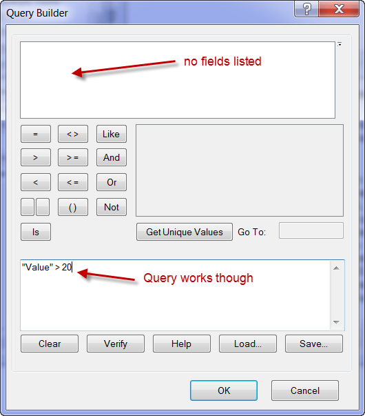
I have a raster (a DEM) in GRID format, source type = continuous, pixel type = floating point, 32 Bit. The field names do not display when I attempt to use this raster in Extract by Attributes tool, nor when I select Properties > Fields of this raster. Does the Extract by Attributes tool not work with floating point data? I got this to work by using raster math INT function but this truncates decimals. Is there a simple workaround other than multiplying raster values by, say, 1000 (to keep three decimal places of value)? Thanks.
3 Replies
08-26-2010
05:57 PM
- Mark as New
- Bookmark
- Subscribe
- Mute
- Subscribe to RSS Feed
- Permalink
Hi,
Did you ever get a response on your thread?
I am experiencing the same issue even though the help documentation for extract by attributes
says it will take a floating point data-set.
Thanks,
Chris
Did you ever get a response on your thread?
I am experiencing the same issue even though the help documentation for extract by attributes
says it will take a floating point data-set.
Thanks,
Chris
06-22-2014
09:48 PM
- Mark as New
- Bookmark
- Subscribe
- Mute
- Subscribe to RSS Feed
- Permalink
I know this post is old, but it's still relevant and good advice. Thanks.
My advice is to follow what's in the image above and keep a SPACE between the operator and numeral.
e.g. "Value" <= 0 NOT "Value" <=0.
kept on getting error messages on such a trivial issue!
My advice is to follow what's in the image above and keep a SPACE between the operator and numeral.
e.g. "Value" <= 0 NOT "Value" <=0.
kept on getting error messages on such a trivial issue!