Turn on suggestions
Auto-suggest helps you quickly narrow down your search results by suggesting possible matches as you type.
Cancel
- Home
- :
- All Communities
- :
- Products
- :
- Data Management
- :
- Data Management Questions
- :
- Re: Problem displaying US Forest Service GeoTiffs ...
Options
- Subscribe to RSS Feed
- Mark Topic as New
- Mark Topic as Read
- Float this Topic for Current User
- Bookmark
- Subscribe
- Mute
- Printer Friendly Page
Problem displaying US Forest Service GeoTiffs in ArcGIS 10.2
Subscribe
7474
11
06-28-2014 10:57 AM
by
Anonymous User
Not applicable
06-28-2014
10:57 AM
- Mark as New
- Bookmark
- Subscribe
- Mute
- Subscribe to RSS Feed
- Permalink
Original User: mwestra2
US Forest Service GeoTiff Topo Maps downloaded from their site aren't displaying correctly in ArcMap. An example of one of their maps is here: http://data.fs.usda.gov/geodata/rastergateway/data/47121/fstopo/470012130_Sun_Top_FSTopo.zip. Other GeoTiffs I download from other sites all seem to work fine (e.g. from USGS site). I can even re-save the USFS GeoTiff as a regular .tif file and then manually georeference it and it and then that works fine as well.
Here's what it looks like in ArcMap : [ATTACH=CONFIG]34966[/ATTACH]
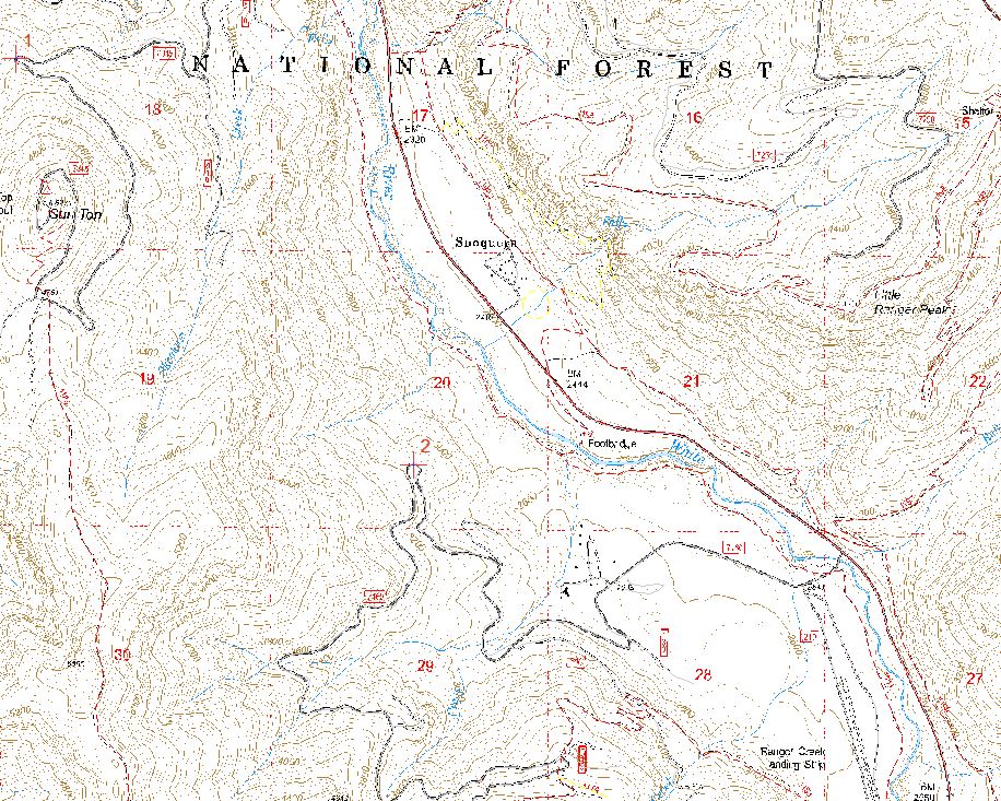
Here's what it's supposed to look like: [ATTACH=CONFIG]34967[/ATTACH]
I've tried different projections and re-sampling. Can anyone help here? My knowledge of raster technology is very limited.
Thanks!
US Forest Service GeoTiff Topo Maps downloaded from their site aren't displaying correctly in ArcMap. An example of one of their maps is here: http://data.fs.usda.gov/geodata/rastergateway/data/47121/fstopo/470012130_Sun_Top_FSTopo.zip. Other GeoTiffs I download from other sites all seem to work fine (e.g. from USGS site). I can even re-save the USFS GeoTiff as a regular .tif file and then manually georeference it and it and then that works fine as well.
Here's what it looks like in ArcMap : [ATTACH=CONFIG]34966[/ATTACH]
Here's what it's supposed to look like: [ATTACH=CONFIG]34967[/ATTACH]
I've tried different projections and re-sampling. Can anyone help here? My knowledge of raster technology is very limited.
Thanks!
11 Replies
06-28-2014
11:38 AM
- Mark as New
- Bookmark
- Subscribe
- Mute
- Subscribe to RSS Feed
- Permalink
The site must contain metadata describing the coordinate system used. Do you know what it is?
by
Anonymous User
Not applicable
06-28-2014
02:15 PM
- Mark as New
- Bookmark
- Subscribe
- Mute
- Subscribe to RSS Feed
- Permalink
Original User: lpinner
In the layer properties (double click the tiff layer in the ArcMap table of contents), go to the Display tab and change the resampling from Nearest to Bilinear. See "Display resampling" in the ArcGIS Help doc - Improving the display of raster data.
In the layer properties (double click the tiff layer in the ArcMap table of contents), go to the Display tab and change the resampling from Nearest to Bilinear. See "Display resampling" in the ArcGIS Help doc - Improving the display of raster data.
12-21-2014
08:16 AM
- Mark as New
- Bookmark
- Subscribe
- Mute
- Subscribe to RSS Feed
- Permalink
Switching to bilinear could make things worse in this case because the data is discrete, even densely discrete. Bilinear resampling is more for continuous data, and even the Improving the display of raster data help page is really geared toward continuous data and not discrete data.
06-28-2014
02:39 PM
- Mark as New
- Bookmark
- Subscribe
- Mute
- Subscribe to RSS Feed
- Permalink
The site must contain metadata describing the coordinate system used. Do you know what it is?
Thanks for the quick reply. Yep, GCS North American 1983 NAD83. From the metadata page (http://data.fs.usda.gov/geodata/rastergateway/states-regions/metadata_geotiff.php): "The images are generated at 600 dpi using ESRI's PLTS MPS Atlas software and can easily be used in GIS and other spatially-referenced applications. The GeoTIFF maps will be cast on the Universal Transverse Mercator Projection (UTM) and the North American Datum of 1983 (NAD83). "
I've tried projecting to different coordinate systems, but no change.
06-28-2014
02:44 PM
- Mark as New
- Bookmark
- Subscribe
- Mute
- Subscribe to RSS Feed
- Permalink
In the layer properties (double click the tiff layer in the ArcMap table of contents), go to the Display tab and change the resampling from Nearest to Bilinear. See "Display resampling" in the ArcGIS Help doc - Improving the display of raster data.
Thanks, I did actually tried that and it does change the appearance on the display and what ends up in an exported PDF or JPG map, but still doesn't do it. The image ends up distorted in a different way.
And I tried resampling different ways but can't figure it out. I didn't know about the Image Analysis window, though. Played around with that quite a bit and can't get anything to improve the image.
by
Anonymous User
Not applicable
06-28-2014
03:16 PM
- Mark as New
- Bookmark
- Subscribe
- Mute
- Subscribe to RSS Feed
- Permalink
Original User: lpinner
What is the coordinate system of your data frame? Have you tried loading the tiff into a new ArcMap session?
What is the coordinate system of your data frame? Have you tried loading the tiff into a new ArcMap session?
06-28-2014
04:01 PM
- Mark as New
- Bookmark
- Subscribe
- Mute
- Subscribe to RSS Feed
- Permalink
What is the coordinate system of your data frame? Have you tried loading the tiff into a new ArcMap session?
Yep. Also tried changing to several different projections / coordinate systems. Doesn't seem to matter.
Here's something I just found... if I create a huge map -- 50"x50" or greater -- and zoom in to 1:5000 to get the extent that I want, then it exports to a reasonable quality JPG or PDF maps. But of course... it's huge and takes forever to export.
by
Anonymous User
Not applicable
06-29-2014
04:13 PM
- Mark as New
- Bookmark
- Subscribe
- Mute
- Subscribe to RSS Feed
- Permalink
Original User: lpinner
Looks like ArcMap doesn't handle resampling colour mapped single band rasters very well. I got it displaying ok by converting from colour map to RGB (Copy Raster (Data Management) tool) then building pyramids (Build Pyramids (Data Management) tool) with bilinear resampling.
Looks like ArcMap doesn't handle resampling colour mapped single band rasters very well. I got it displaying ok by converting from colour map to RGB (Copy Raster (Data Management) tool) then building pyramids (Build Pyramids (Data Management) tool) with bilinear resampling.
06-30-2014
01:54 PM
- Mark as New
- Bookmark
- Subscribe
- Mute
- Subscribe to RSS Feed
- Permalink
Tried... Still no dice getting those to display, print or export without having to use a huge map (at least 50"x50").