- Home
- :
- All Communities
- :
- Products
- :
- Data Management
- :
- Data Management Questions
- :
- Re: Polyline to Circle
- Subscribe to RSS Feed
- Mark Topic as New
- Mark Topic as Read
- Float this Topic for Current User
- Bookmark
- Subscribe
- Mute
- Printer Friendly Page
- Mark as New
- Bookmark
- Subscribe
- Mute
- Subscribe to RSS Feed
- Permalink
Hi,
I have a layer of 120 polylines created from XY coordinates of start and end points. I now would like to create a layer of circles (polylines not polygons) with one end point of each polyline as the center and the other end point of the polyline as the outer radius.
How do I do this?
Thanks!
Solved! Go to Solution.
Accepted Solutions
- Mark as New
- Bookmark
- Subscribe
- Mute
- Subscribe to RSS Feed
- Permalink
Hi,
You could follow the following workflow.
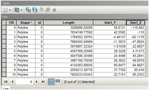
1) Add 3 fields to the polyline layer, viz., Length (in meters), Start_X (X Coordinate/Longitude of Starting point), and Start_Y (Y Coordinate/Latitude of Starting point) using Calculate Geometry in the attribute table.

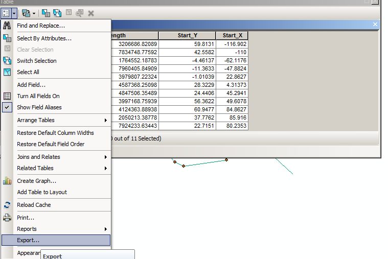
2) Export the attribute table to a table file (e.g. *.dbf)

3) In ArcCatalog, create XY point feature class from the above table file. Define a GCS spatial reference.

4) Reproject the shapefile to a projected coordinate system (e.g. UTM).
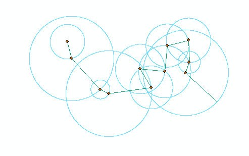
5) Use Buffer (Analysis) tool to build the Circles, as desired.

Note: We are reprojecting the points to PCS, so that the buffer takes up linear units (meters) and not angular units (Degree Decimal).
I hope it solves your issue.
Thanks,
Jay
Think Location
- Mark as New
- Bookmark
- Subscribe
- Mute
- Subscribe to RSS Feed
- Permalink
Hi,
You could follow the following workflow.
1) Add 3 fields to the polyline layer, viz., Length (in meters), Start_X (X Coordinate/Longitude of Starting point), and Start_Y (Y Coordinate/Latitude of Starting point) using Calculate Geometry in the attribute table.

2) Export the attribute table to a table file (e.g. *.dbf)

3) In ArcCatalog, create XY point feature class from the above table file. Define a GCS spatial reference.

4) Reproject the shapefile to a projected coordinate system (e.g. UTM).
5) Use Buffer (Analysis) tool to build the Circles, as desired.

Note: We are reprojecting the points to PCS, so that the buffer takes up linear units (meters) and not angular units (Degree Decimal).
I hope it solves your issue.
Thanks,
Jay
Think Location
- Mark as New
- Bookmark
- Subscribe
- Mute
- Subscribe to RSS Feed
- Permalink
Forgot to add my output snapshot!!!

Think Location
- Mark as New
- Bookmark
- Subscribe
- Mute
- Subscribe to RSS Feed
- Permalink
Extremely helpful! Thanks Jay!