Turn on suggestions
Auto-suggest helps you quickly narrow down your search results by suggesting possible matches as you type.
Cancel
- Home
- :
- All Communities
- :
- Products
- :
- Data Management
- :
- Data Management Questions
- :
- Re: Polygon with given length and width JLF
Options
- Subscribe to RSS Feed
- Mark Topic as New
- Mark Topic as Read
- Float this Topic for Current User
- Bookmark
- Subscribe
- Mute
- Printer Friendly Page
Polygon with given length and width JLF
Subscribe
1119
2
10-11-2017 01:45 PM
2 Replies
10-11-2017
01:53 PM
- Mark as New
- Bookmark
- Subscribe
- Mute
- Subscribe to RSS Feed
- Permalink
- Projected into what?
- NAD83 is a datum not a projection
- It can be done if you don't care where it is.
Perhaps you have other details that you could share.
10-14-2017
03:54 PM
- Mark as New
- Bookmark
- Subscribe
- Mute
- Subscribe to RSS Feed
- Permalink
I totally agree with Dan.
It can be done, but a little bit more info would be appreciated. To create a rectangle you will need coordinates. You can create them randomly but you will still need some range of valid values. See below a sample script that will create a number of rectangles. In this case I took the projected coordinate system with NAD 1983 as datum and defined an extent for values values for xmin and ymin of the rectangles to be created:
def main():
import arcpy
import random
arcpy.env.overwriteOutput = True
# some settings
fc_out = r'C:\GeoNet\RandomRectangle\test2.shp'
width = 10000
height = 5000
xy_extent = arcpy.Extent(2048900, 549400, 2094700, 573600)
number_of_rectangles = 25
# NAD_1983_2011_StatePlane_California_V_FIPS_0405
sr_pcs = arcpy.SpatialReference(103001)
feats = []
for i in range(number_of_rectangles):
# get a random xmin and ymin of the rectangle
xmin = random.randrange(xy_extent.XMin, xy_extent.XMax)
ymin =random.randrange(xy_extent.YMin, xy_extent.YMax)
# create the rectangle
pnts = [[xmin, ymin],
[xmin, ymin + height],
[xmin + width, ymin + height],
[xmin + width, ymin],
[xmin, ymin]]
polygon = arcpy.Polygon(arcpy.Array([arcpy.Point(*pnt) for pnt in pnts]), sr_pcs)
feats.append(polygon)
# write the rectangle to the output fc
arcpy.CopyFeatures_management(feats, fc_out)
if __name__ == '__main__':
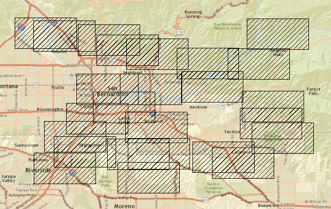
main()And the result:
Could you elaborate a little more on what you are trying to achieve?