- Home
- :
- All Communities
- :
- Products
- :
- Data Management
- :
- Data Management Questions
- :
- Re: Polygon 'footprints'
- Subscribe to RSS Feed
- Mark Topic as New
- Mark Topic as Read
- Float this Topic for Current User
- Bookmark
- Subscribe
- Mute
- Printer Friendly Page
- Mark as New
- Bookmark
- Subscribe
- Mute
- Subscribe to RSS Feed
- Permalink
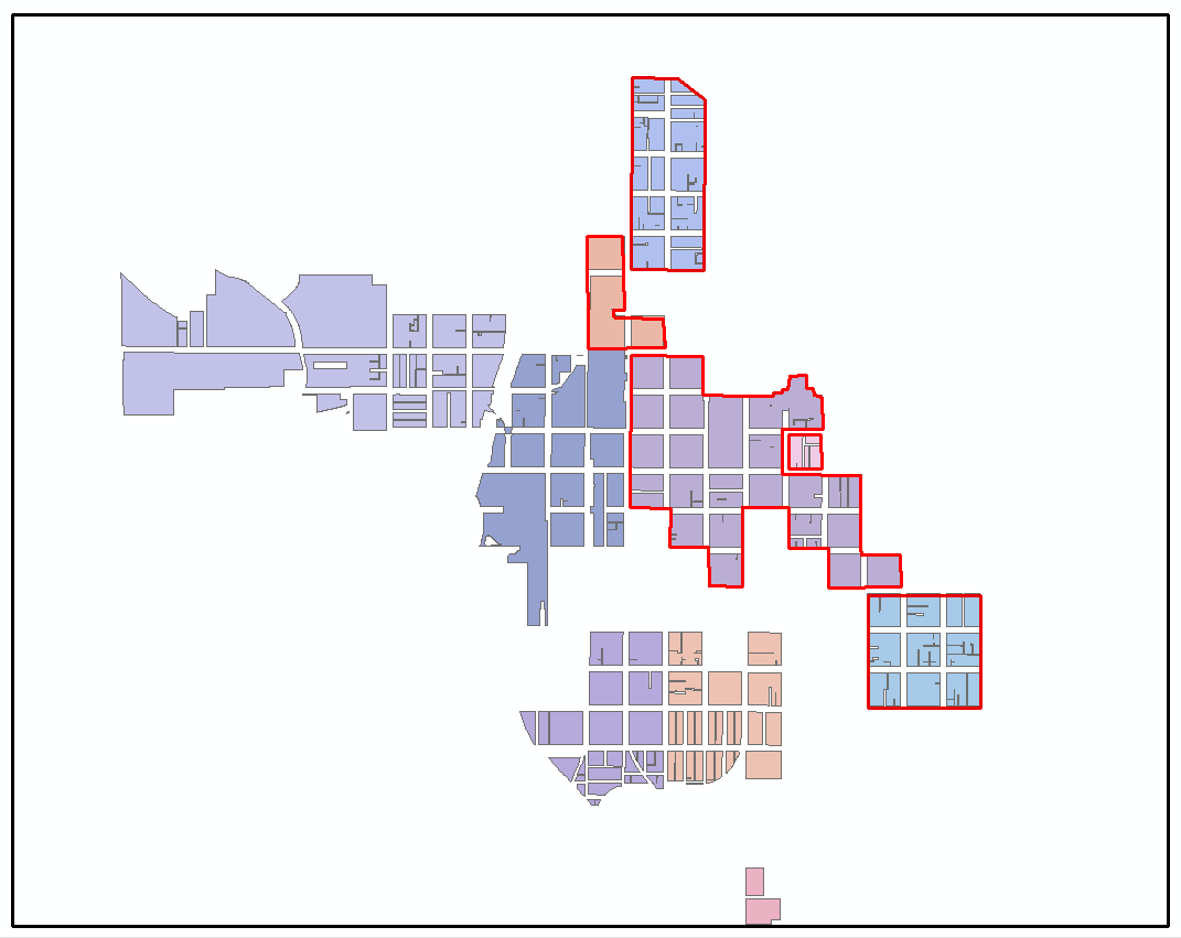
I have a polygon feature set that represents urban renewal projects (see sample image of data below). The original polygons were derived by dissolving parcels; hence the regular linear gaps which are where street centerlines are. I'd like to do something akin to aggregate polygons however, given that quite a number of the projects abut others, aggregate is out. Basically, what I'd like is something that looks like the red outline footprint I've sketched around a couple of the project areas; is there a tool to do such a task rather than drawing by hand?
Solved! Go to Solution.
Accepted Solutions
- Mark as New
- Bookmark
- Subscribe
- Mute
- Subscribe to RSS Feed
- Permalink
Some ideas of the top of my head. Neither will totally solve the challenge, but may spur ideas:
1. Contact the County Assessors office for the Right-of-Way (ROW) polygons and then use the Merge geoprocessing tool to combine them with the Urban Renewal polygons. Then Select ones that belong together while in an editing session and use the editing Merge to then come up with one large polygon for each set of urban areas. This may entail some Cutting of the ROW parts to match the urban areas.
2. If the ROW polygons are not available, find some overall large polygon feature class that extends beyond the Urban Renewal polygons and use the Erase geoprocessing tool to come up with the difference. Then Merge the Erased feature class with the Urban Renewal polygons. In editing mode cut the added Erase polygons where need be, then in editing mode use the editing Merge to join them together. Alternately, it may work to use Eliminate for this last part.
Eliminate—Data Management toolbox | ArcGIS Desktop
3. Just a guess - I bet there is a raster way to do this. Or with Bounding Boxes. This guy might know: Dan Patterson
Chris Donohue, GISP
- Mark as New
- Bookmark
- Subscribe
- Mute
- Subscribe to RSS Feed
- Permalink
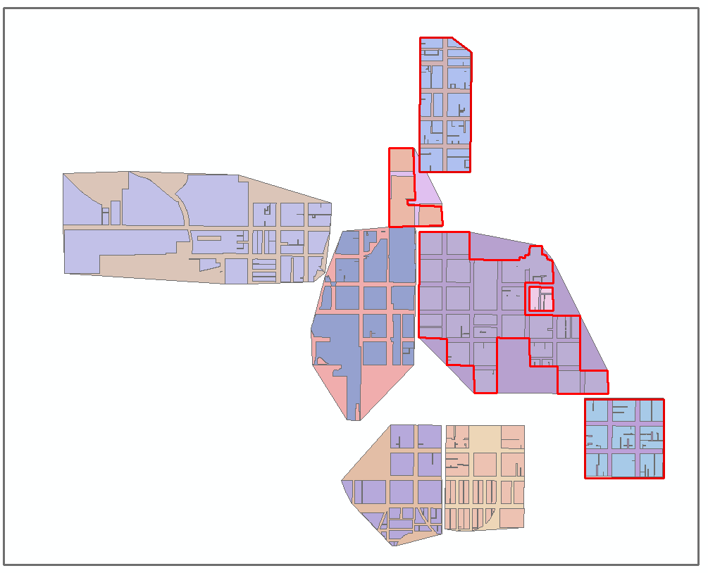
Thanks Chris- I just played around convex hulls/ bounding boxes. Not perfect, but not bad either.....
- Mark as New
- Bookmark
- Subscribe
- Mute
- Subscribe to RSS Feed
- Permalink
That's not bad. Better than the first two ideas I posted.
Chris Donohue, GISP
- Mark as New
- Bookmark
- Subscribe
- Mute
- Subscribe to RSS Feed
- Permalink
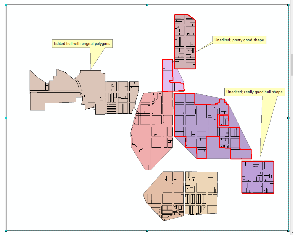
With a little cutting, trimming and re-shaping they get looking pretty good pretty quick. Some take a little more edits than others:
- Mark as New
- Bookmark
- Subscribe
- Mute
- Subscribe to RSS Feed
- Permalink
Polygons are much easier than working with street data.... 
Chris Donohue, GISP
- Mark as New
- Bookmark
- Subscribe
- Mute
- Subscribe to RSS Feed
- Permalink
It is a Concave Hull... recently implemented for Pro
- Mark as New
- Bookmark
- Subscribe
- Mute
- Subscribe to RSS Feed
- Permalink
Dan- I did mine in ArcMap- is the tool you refer to something you wrote? How does it differ from the arcmap version?
- Mark as New
- Bookmark
- Subscribe
- Mute
- Subscribe to RSS Feed
- Permalink
Yes Joe, I cobbled it together for PRO. Don't know about the arcmap version, but I suspect there is something floating around.,
NOTE, there is no 'ONE' concave hull.. the result depends on the rules being used (of course I used the best rules )
- Mark as New
- Bookmark
- Subscribe
- Mute
- Subscribe to RSS Feed
- Permalink
Dan- This was my first step into bounding geometry: here is the link that I followed : Minimum Bounding Geometry—Help | ArcGIS Desktop . The 'convex' hull is what I went with, and it's really straightforward; no rules. I'm going to download yours and give it a spin. Our office has a lidar derived building footprint project going on, and I'd like to apply one of these to it and see how it works out.
Thanks-
ps: will yours work with polygons or just points?