- Home
- :
- All Communities
- :
- Products
- :
- Data Management
- :
- Data Management Questions
- :
- Re: Points to Line tool does not recognize the ext...
- Subscribe to RSS Feed
- Mark Topic as New
- Mark Topic as Read
- Float this Topic for Current User
- Bookmark
- Subscribe
- Mute
- Printer Friendly Page
Points to Line tool does not recognize the extent
- Mark as New
- Bookmark
- Subscribe
- Mute
- Subscribe to RSS Feed
- Permalink
Hi everyone,
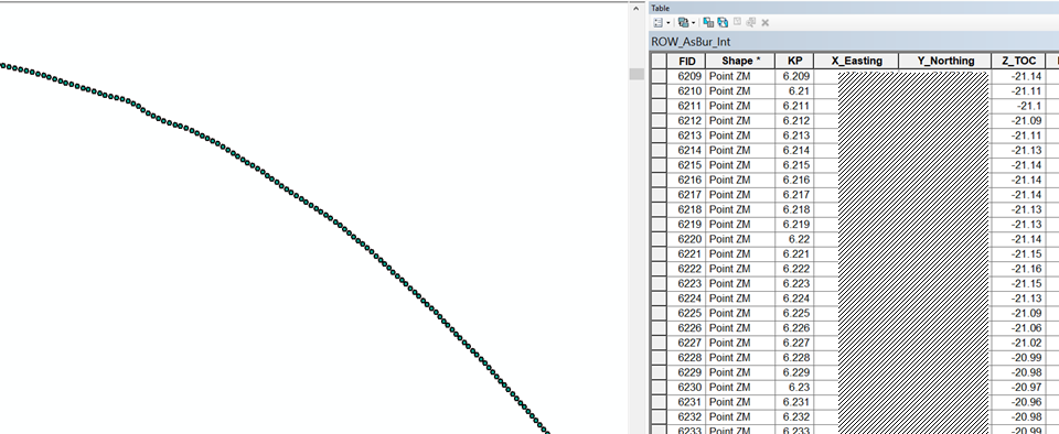
I have a trouble with the "Points to Line" tool. First I have a point shape file layers with XYZ coordinates (see image below). For info, the shape file comprise >6000 points. This point shapefile layer has a projected coordinate system.
After using the point to line (Data Management) tool with "Sort Field" option with the KP, ArcGIS does not plot the line shapefile. Although the tool is running without warning or error, the output line does not appear on the screen as lateral extent of the output layer is unkown (see image below).
I already used this tool before and I worked perfectly fine before, I do not known what could be wrong here. Thank you in advance for your help
- Mark as New
- Bookmark
- Subscribe
- Mute
- Subscribe to RSS Feed
- Permalink
Hard to tell. I cannot see your x,y locations and your projection
- Mark as New
- Bookmark
- Subscribe
- Mute
- Subscribe to RSS Feed
- Permalink
Robert,
Thank you but I do not know if the client's supplied data are subject to confidentiality issues
- Mark as New
- Bookmark
- Subscribe
- Mute
- Subscribe to RSS Feed
- Permalink
When you say 'you can't see it'... does it add a layer to the table of contents?
If it does, select the layer and 'zoom to layer'
If the layer appears, then X and Y are switched or some other common mistake.
If the layer doesn't exist, then there may be something wrong with the points themselves
- Mark as New
- Bookmark
- Subscribe
- Mute
- Subscribe to RSS Feed
- Permalink
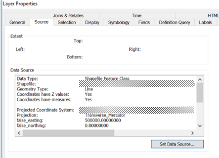
So it did generate a feature in the output shapefile? If so, did you investigate if the feature consists of the points that you provided as input (in an edit session)? As mentioned before, if something is not drawing this could be due to a mismatch in the used coordinate system.
If it would have worked the output would not have respected the Z values. You can also script it, using this example as basis: Convert 3D points to 3D lines (underground well data)
- Mark as New
- Bookmark
- Subscribe
- Mute
- Subscribe to RSS Feed
- Permalink
Good afternoon Dan,
Yes a new (line) layer is created in the table of content. Even with the "zoom to layer" the line is not displayed on the map. I try to do the same point to line with QGGIS and I also have a problem. So I guess that the problem comes from my points.
- Mark as New
- Bookmark
- Subscribe
- Mute
- Subscribe to RSS Feed
- Permalink
can you show a copy of the points table... you can use the Add Geometry Attributes tool in ArcMap or PRO to get the coordinate values if there are any
- Mark as New
- Bookmark
- Subscribe
- Mute
- Subscribe to RSS Feed
- Permalink
Any reason for sorting the field based on KP field, which looks like Float/Double datatype?
Have you also filled Line_Field parameter?
What happens if you keep all the optional parameters blank?
Think Location
- Mark as New
- Bookmark
- Subscribe
- Mute
- Subscribe to RSS Feed
- Permalink
All,
My mistake was not related to ArcGIS software but the was I saved my .csv files and exported them to point shapefile.
The feature is not working with .csv UTF-8 files. A way to get-around is to export raw data in .txt format.