- Home
- :
- All Communities
- :
- Products
- :
- Data Management
- :
- Data Management Questions
- :
- Re: Points to line data X symbol in red circle nex...
- Subscribe to RSS Feed
- Mark Topic as New
- Mark Topic as Read
- Float this Topic for Current User
- Bookmark
- Subscribe
- Mute
- Printer Friendly Page
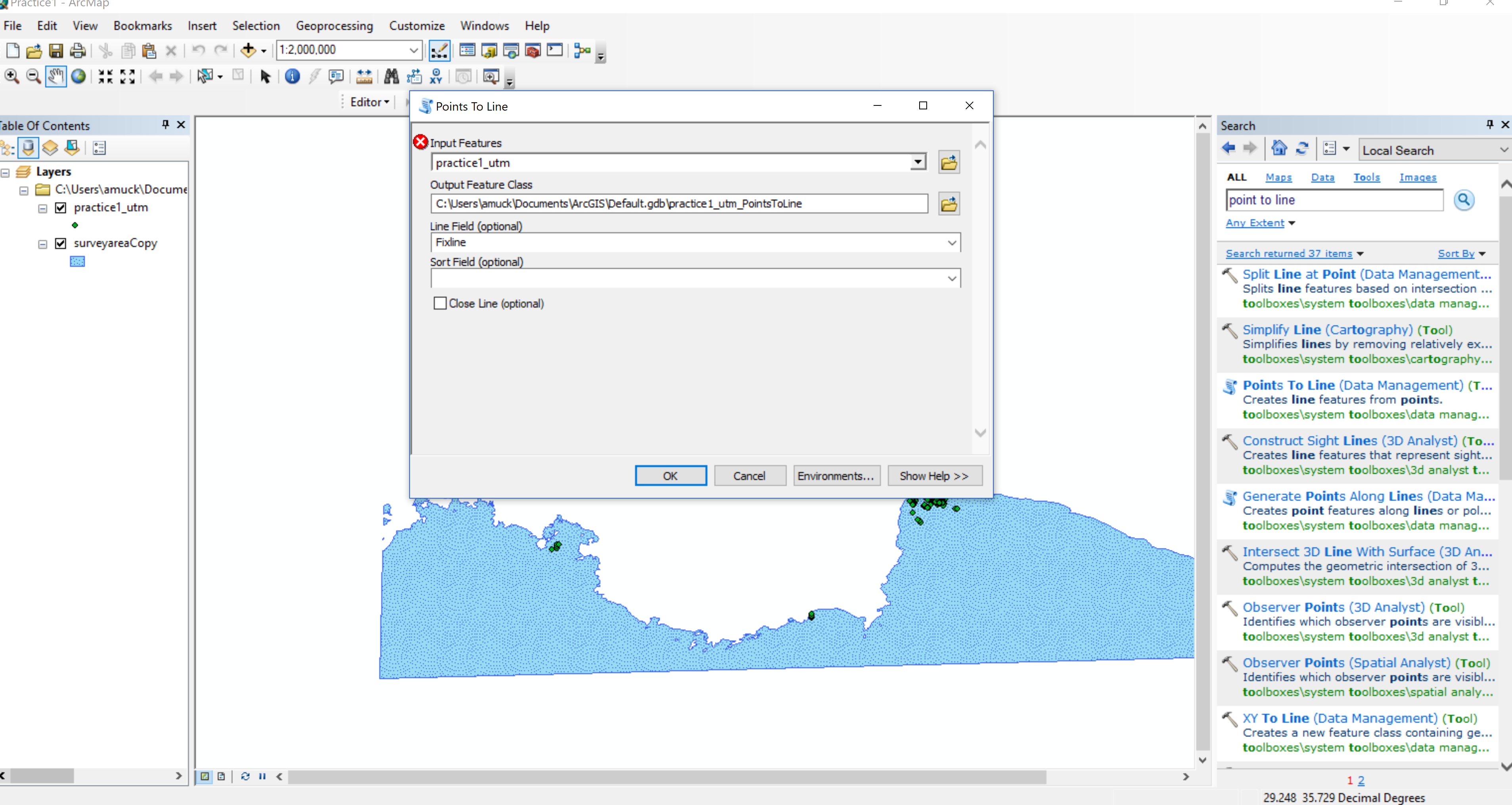
Points to line data X symbol in red circle next to input feature when opening
- Mark as New
- Bookmark
- Subscribe
- Mute
- Subscribe to RSS Feed
- Permalink
Hello,
I am using ArgGis 10.5.1. I am trying to use Points to Line tool but when I open it it automatically comes up with an X symbol in red next to input feature (I've attached a photo). I have tried inputting all the necessary data and pressing OK but it simply says error with a yellow triangle and ! inside it. I used this tool yesterday on the same data set and it worked without a problem. I have also tried closing out of Arcmap as well as restarting my computer. Any suggestions or advice would be very helpful!
Thank you
Solved! Go to Solution.
Accepted Solutions
- Mark as New
- Bookmark
- Subscribe
- Mute
- Subscribe to RSS Feed
- Permalink
You might try
- seeing if another user gets the same issue on your machine
- if the above proves not to be the problem, then try an application reset https://community.esri.com/docs/DOC-2121-resetting-your-arcgis-application-profile
- if that fails, go to Windows control panel and find 'add/remove programs' and from within there try a 'Repair'
if it isn't the data, the location (which you didn't report! ), someone else's profile or yours, then a repair may fix it.
If the X only appeared recently, then it could also be due to recent updates on your computer.
- Mark as New
- Bookmark
- Subscribe
- Mute
- Subscribe to RSS Feed
- Permalink
If one clicks on the red X, it often will then display an error message. Sometimes the message will provide more specifics as to what the issue is.
Also, as general practice try to avoid using the default geodatabase at C:\Users\... Documents\. I don't know the exact reason, but it seems that this particular location has led to issues for many folks, including what appears to be going on for you.
Some solution possibilities to consider if the error turns out be the dreaded Error 999999:
Troubleshooting Error 999999 in ArcMap and ArcGIS | IT Help Site
Chris Donohue, GISP
- Mark as New
- Bookmark
- Subscribe
- Mute
- Subscribe to RSS Feed
- Permalink
Hi Chris,
Thanks for the reply! Unfortunately nothing comes up when I click on the X. I am new to GIS, Could you suggest to me where to create another geodatabase?
- Mark as New
- Bookmark
- Subscribe
- Mute
- Subscribe to RSS Feed
- Permalink
I'd place it on a short path from the C: drive if possible. Something like:
C:\GIS\Projects or similar
As for the folder naming, be there are several issues that can come up with GIS files that are not obvious. Most important, avoid at all costs using a space in any folder name (or file name). Then there are several more restrictions that come into play for different file types. Here's the most extreme restrictions. If you adhere to these (even though you are don't appear to be working with rasters), you should be good to go for all GIS work.
Output raster formats and names—ArcGIS Help | ArcGIS Desktop
Chris Donohue, GISP
- Mark as New
- Bookmark
- Subscribe
- Mute
- Subscribe to RSS Feed
- Permalink
Hi Chris,
I followed your suggestions of creating a new short path, not using any spaces and followed the guidelines you linked in. Still no luck, as I mentioned below to Dan, my arcmap comes up with this error even when I do not have a map or any data open in it. Not sure if you or anyone has any other ideas to fix it.
Thank you,
Aurelie
- Mark as New
- Bookmark
- Subscribe
- Mute
- Subscribe to RSS Feed
- Permalink
Along with Chris's suggestions, is there any chance that the file isn't a featureclass but an event layer?. To ensure that you are getting the right information, rather than clicking on the little drop down arrow besides the layer name, navigate to the geodatabase and select the featureclass from there.
If it isn't a featureclass, make it one.
- Mark as New
- Bookmark
- Subscribe
- Mute
- Subscribe to RSS Feed
- Permalink
Hi Dan,
Thanks for info! I did check and it is a feature class. It's strange because the error pops up when I have no map in either.
- Mark as New
- Bookmark
- Subscribe
- Mute
- Subscribe to RSS Feed
- Permalink
You might try
- seeing if another user gets the same issue on your machine
- if the above proves not to be the problem, then try an application reset https://community.esri.com/docs/DOC-2121-resetting-your-arcgis-application-profile
- if that fails, go to Windows control panel and find 'add/remove programs' and from within there try a 'Repair'
if it isn't the data, the location (which you didn't report! ), someone else's profile or yours, then a repair may fix it.
If the X only appeared recently, then it could also be due to recent updates on your computer.
- Mark as New
- Bookmark
- Subscribe
- Mute
- Subscribe to RSS Feed
- Permalink
Hi Dan,
I went through the Windows control panel and repaired Arcmap and the error is gone! Thank you very much 
Regards,
Aurelie