- Home
- :
- All Communities
- :
- Products
- :
- Data Management
- :
- Data Management Questions
- :
- Please help - Arc GIS Question
- Subscribe to RSS Feed
- Mark Topic as New
- Mark Topic as Read
- Float this Topic for Current User
- Bookmark
- Subscribe
- Mute
- Printer Friendly Page
Please help - Arc GIS Question
- Mark as New
- Bookmark
- Subscribe
- Mute
- Subscribe to RSS Feed
- Permalink
Hello,
I am having serious trouble with a geodatabase assignment. The assignment requires us to go to a park, locate thrity something points by longitude and latitude, and then plot them on a map in ArcMap 10.2. However, I was sent a file to use, I believe it contains metadata as each file contains an extension like .atx, .gdbtablx, .spx, etc. When I try to connect to the folder in ArcCatalog, it doesn't even show up as visible. I've also tried connecting to the folder through ArcMap, and even dragging and dropping. How do I use this information in ArcMap?
Any suggestion is welcome, and thank you in advance!!!!
- Mark as New
- Bookmark
- Subscribe
- Mute
- Subscribe to RSS Feed
- Permalink
Hi Desirae,
It appears you are trying to use a File Geodatabase. These files should be within a folder with a .gdb extension. Could you send a screen shot of how the data appears in Windows Explorer?
- Mark as New
- Bookmark
- Subscribe
- Mute
- Subscribe to RSS Feed
- Permalink
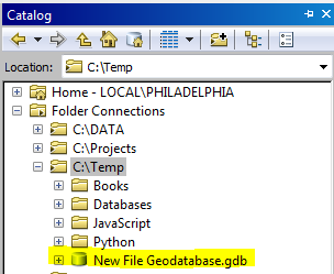
Yes, this is a file geodatabase. Copy the 'New File Geodatabase.gdb' to a directory, i.e. 'C:\temp'. Then, in the Catalog window, you should see the geodatabase:
- Mark as New
- Bookmark
- Subscribe
- Mute
- Subscribe to RSS Feed
- Permalink
would it be okay if you walked me through this over the phone? I am truly having a difficult time getting my data to show up
- Mark as New
- Bookmark
- Subscribe
- Mute
- Subscribe to RSS Feed
- Permalink
Tech Support will be able to. You can call them at 888-377-4575 and log an incident.
- Mark as New
- Bookmark
- Subscribe
- Mute
- Subscribe to RSS Feed
- Permalink
thank you!
- Mark as New
- Bookmark
- Subscribe
- Mute
- Subscribe to RSS Feed
- Permalink
I do have another question for you. So, is the geodatabase folder that I have ready to be used in ArcMap? Do I have to use it in ArcCatalog first? If I finally do get it to show up in ArcCatalog, then do I create feature classes and all of that? I just want to make sure that I'm not giving myself extra work. My only objective is to make a map. My professor sent me that Geodatabase file, and I am really at a lost for what to do with it.
- Mark as New
- Bookmark
- Subscribe
- Mute
- Subscribe to RSS Feed
- Permalink
thank you so much, it worked!!!
- Mark as New
- Bookmark
- Subscribe
- Mute
- Subscribe to RSS Feed
- Permalink
Don't forget to mark Sol's answer as correct!