- Home
- :
- All Communities
- :
- Products
- :
- Data Management
- :
- Data Management Questions
- :
- NITF and ArcGIS
- Subscribe to RSS Feed
- Mark Topic as New
- Mark Topic as Read
- Float this Topic for Current User
- Bookmark
- Subscribe
- Mute
- Printer Friendly Page
NITF and ArcGIS
- Mark as New
- Bookmark
- Subscribe
- Mute
- Subscribe to RSS Feed
- Permalink
For those familiar with the US national imagery transmission format (NITF):
- Are you using the free download, NITF for ArcGIS?
- Is the NITF for ArcGIS sufficient?
- What additional capability do you want when working with NITF data?
Breaking news! NITF for ArcGIS is now available for ArcGIS 10.2 at www.esri.com/nitf
- Mark as New
- Bookmark
- Subscribe
- Mute
- Subscribe to RSS Feed
- Permalink
Hi Fred,
can´t give you answers to your questions right now, but am collecting opinions/requirements referring to questions 2 and 3 from the community and will come back to you as soon as possible.
Is seems that the link to the NITF page www.esri.com/nitf is broken. Maybe that could be fixed.
Thanks
Sebastian
- Mark as New
- Bookmark
- Subscribe
- Mute
- Subscribe to RSS Feed
- Permalink
1) NITF for ArcGIS Desktop is only released for ArcMap and Server (Not Pro) via Esri Downloads
2 & 3) ArcGIS Pro and the Image Analyst Extension is moving ArcGIS into the remote sensing domain. But a lack of support for Substitute Sensor Models can potentially limit the use of ArcGIS Pro.
- Mark as New
- Bookmark
- Subscribe
- Mute
- Subscribe to RSS Feed
- Permalink
Hi Thomas L: Thanks for posting here regarding NITF and ArcGIS at it seems that this topic kind of fall asleep.
As of my understandig, in ArcMap and ArcGIS Server the Reading and the Creation of NITF-Files is possible by using the above mentioned toolbars, available in the Esri Downloads.
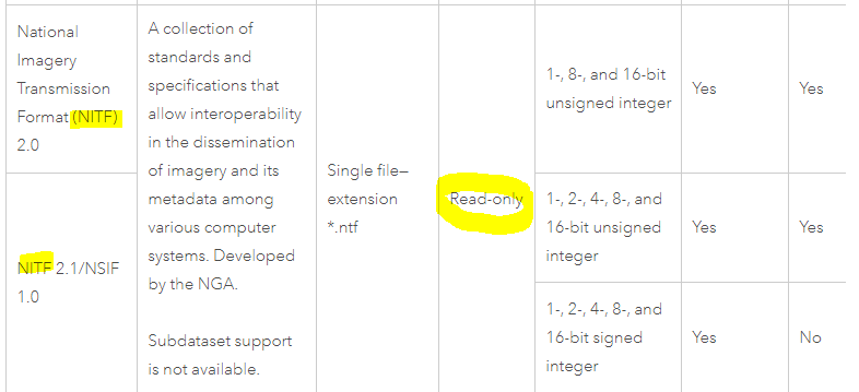
ArcGIS Pro supports NITF just for reading, see https://pro.arcgis.com/en/pro-app/help/data/imagery/supported-raster-dataset-file-formats.htm .
So the key-question is, how can an ArcGIS Pro User create and/or edit NITF Files as we know that the ArcMap era will not last forever.