- Home
- :
- All Communities
- :
- Products
- :
- Data Management
- :
- Data Management Questions
- :
- Re: Moving ArcGIS Data To New Computer
- Subscribe to RSS Feed
- Mark Topic as New
- Mark Topic as Read
- Float this Topic for Current User
- Bookmark
- Subscribe
- Mute
- Printer Friendly Page
- Mark as New
- Bookmark
- Subscribe
- Mute
- Subscribe to RSS Feed
- Permalink
I have a feeling that I'm not framing this question properly and for that I apologize, nevertheless:
My ArcGIS licensed products are on computer A. My map data [.mxd, rasters, layers, etc.], including geodatabase, are on Computer B. I do this I as I have offisite backup attached to Computer B. Computer A has only local backup.
Computer B is threatening to go south so I bought a replacement for it; called Computer C.
I copied the database and map files from Computer B to Computer C, using the same directory names on both.
i copied the .prj and .txt files and related subdirectories [which are in a subdirectory \ArcGIS on Computer B] to Computer C, keeping the same subdirectory name.
I reset the Home directory in the Catalog so that it points to Computer C. When I restart ArcGIS, I see the new Home directory.
When I go to load a map [.mxd], however, I'm seeing the base map in it's proper extent, but I'm not seeing the layers that are associated with the .mxd file. If I, however, authenticate to Computer B [the old one], all is well. Obviously I've missed some step in the transfer, but I can't work out what that might be.
Would very much appreciate a pointer to the appropriate part of the ArcGIS help file that explains this. [I've tried various search options on the Help file, but never seem to get quite the right set of search words].
Many thanks, Bill Cole
Solved! Go to Solution.
Accepted Solutions
- Mark as New
- Bookmark
- Subscribe
- Mute
- Subscribe to RSS Feed
- Permalink
You can also right click on the mxd in ArcCatalog and use Set Data Sources.
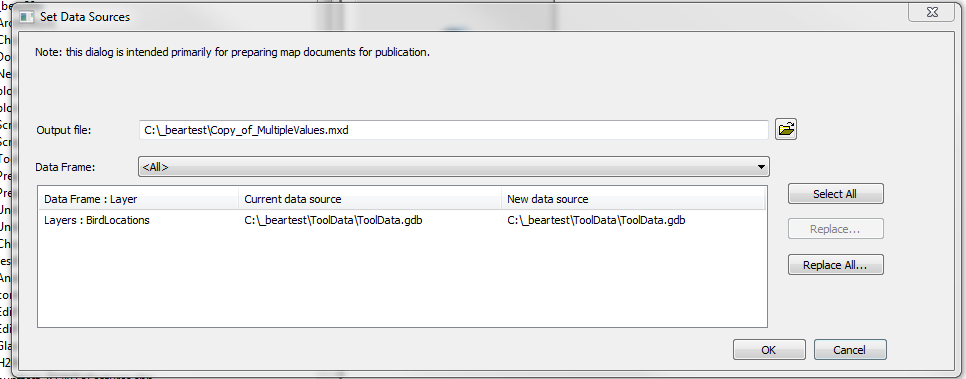
If you have a lot of mxd's so this isn't practical, I have a addin that can help. But typically if you map the new machine drives the same way as the old machine (i.e. if you referenced the data thry drive "F" and map the new as drive "F" with the rest of the path the same), it should work.
There are many ways to accomplish this, just depends on the magnitude/quantity of changes that are needed.
- Mark as New
- Bookmark
- Subscribe
- Mute
- Subscribe to RSS Feed
- Permalink
If you got the little exclamation mark indicating that the path to the file can't be found, you just need to right-click on the first such layer, re-establish the path to the new data and the rest should follow along IF the paths were set to "use relative paths" at the project level.
- Mark as New
- Bookmark
- Subscribe
- Mute
- Subscribe to RSS Feed
- Permalink
Dan, thanks. I do see the red exclamation icon, I don't though recall if the project was set to relative paths. Unfortunately just I went to sort this out, my SMB network crashed. Will check this out when i'm back up.
Regards, Bill Cole
- Mark as New
- Bookmark
- Subscribe
- Mute
- Subscribe to RSS Feed
- Permalink
Xander, thanks. I do see the red exclamation icon, I don't though
recall if the project was set to relative paths. Unfortunately just I
went to sort this out, my SMB network crashed. Will check this out when
i'm back up.
- Mark as New
- Bookmark
- Subscribe
- Mute
- Subscribe to RSS Feed
- Permalink
You can also right click on the mxd in ArcCatalog and use Set Data Sources.
If you have a lot of mxd's so this isn't practical, I have a addin that can help. But typically if you map the new machine drives the same way as the old machine (i.e. if you referenced the data thry drive "F" and map the new as drive "F" with the rest of the path the same), it should work.
There are many ways to accomplish this, just depends on the magnitude/quantity of changes that are needed.
- Mark as New
- Bookmark
- Subscribe
- Mute
- Subscribe to RSS Feed
- Permalink
Thank you very much for pointing me to this. I finally got the network back and have - undoubtedly done the hard way - changed the Data Sources on each of the maps in my maps collection to point to the new computer.
My primary map is a collection of georeferenced USGS historic topo quadrant rasters which were attached to the ArcGIS topo base map by dragging them on to it [after each had been individually georeferenced]. Using ArcCatalog I changed the Data Storage locations on each of these individual maps. Each were then opened with ArcMap, and re-checked to be sure that they were collecting data from the proper computer and were properly displaying the rasters. However, to get the USGS historic topo raster images to display I had to open the Link Table associated with the map and then save the map. Once this was done these maps displayed correctly. Other that the USGS raster, there are no other layers associated with these individual maps. All of the feature layers are associated with the primary map.
However, the primary map - the one which was assembled by dragging each of the quadrant maps on to it - shows all of the features correctly against the ArcGIS base topo map, but does not show the underlying USGS historic topo quadrant rasters as it use to before the files were moved. In the hope of fixing this, I went to each associated raster file [.jpg] and made sure that the Data Source was pointing to the correct computer. However, making this change did not result in the appearance of the missing rasters on the primary map. Clearly I'm, again, missing something
Thanks very much, Bill Cole
- Mark as New
- Bookmark
- Subscribe
- Mute
- Subscribe to RSS Feed
- Permalink
Bill, I have a addin Python addin for data inventory and “broken-link” repair. and one of the tools is to make a report of all (unique) broken links with in a workspace (recursive). Might help you see a pattern. You can use it to fix paths too. Since it walks thru all the mxd's it makes it easier if you have a lot of them.
- Mark as New
- Bookmark
- Subscribe
- Mute
- Subscribe to RSS Feed
- Permalink
Rebecca, thanks for the pointer. I read the documentation page, which looks promising, and then went to the page to download the tool. That page asked that I click on "the attachment below" to download, but, unless I totally missed it, cannot see an attachment link. I tried this [logged in] on a couple of browsers just to make sure that it wasn't a browser problem, but got the same result on both. If I makes a difference, I'm using Windows 10 with Firefox to do the internet browsing. I also tried Edge. I will say that the machine that I run ArcGIS from is Windows 7 and will remain that way until 10.4.
Bill
- Mark as New
- Bookmark
- Subscribe
- Mute
- Subscribe to RSS Feed
- Permalink
Just found it at the top of the page under the Open [who knew] button. My apologies. Now to give it a whirl.
Bill
- Mark as New
- Bookmark
- Subscribe
- Mute
- Subscribe to RSS Feed
- Permalink
Actually, my tool would be at the bottom of the description
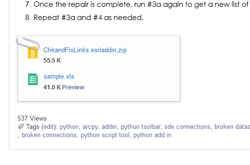
But the other tool might work for you too.