Turn on suggestions
Auto-suggest helps you quickly narrow down your search results by suggesting possible matches as you type.
Cancel
- Home
- :
- All Communities
- :
- Products
- :
- Data Management
- :
- Data Management Questions
- :
- Mosaic Dataset only some overviews display
Options
- Subscribe to RSS Feed
- Mark Topic as New
- Mark Topic as Read
- Float this Topic for Current User
- Bookmark
- Subscribe
- Mute
- Printer Friendly Page
Mosaic Dataset only some overviews display
Subscribe
4706
4
03-19-2014 09:33 AM
03-19-2014
09:33 AM
- Mark as New
- Bookmark
- Subscribe
- Mute
- Subscribe to RSS Feed
- Permalink
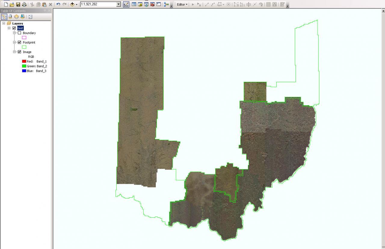
[ATTACH=CONFIG]32326[/ATTACH]
Good Afternoon,
I am using Arc GIS 10.2 and am in the process of creating a state wide mosaic dataset of several smaller mosaic datasets. During the process I add new Rasters and then build the overviews. As you can see in the top right portion of my attachment the overviews will not display at the full extent. If I zoom in (even slightly) then the overviews for that area appear. The overviews of the individual datasets appear at all scales so the issue isnt with the datasets that I am adding to the statewide dataset. I also have the same issue in the bottom left corner of my picture. Has anyone ever experienced this issue and how did you fix it? I am trying to create an image service of the entire state of imagery by loading it into one mosaic dataset.
Thanks,
Jennifer
4 Replies
03-19-2014
09:51 AM
- Mark as New
- Bookmark
- Subscribe
- Mute
- Subscribe to RSS Feed
- Permalink
Hi Jennifer,
I would recommend rebuilding all of the overviews to see if this fixes the issue. To do so, right-click on the mosaic dataset in the catalog window > Optimize > Build Overviews. Uncheck the last two options to rebuild all overviews. Ex:
[ATTACH=CONFIG]32331[/ATTACH]
I guess I should have added that I have already tried this several times. However I forgot to uncheck the only generate stale overviews. Thanks do you have any more suggestions?
I closed Arc Map and re opened it and ta da there are my overviews. Then they disappeared again. I have no clue what is going on. I change extents and they disappear. I am so confused.
Thanks so much.
03-19-2014
10:05 AM
- Mark as New
- Bookmark
- Subscribe
- Mute
- Subscribe to RSS Feed
- Permalink
Jake -- thanks its fixed. I have no idea whats going on with that server but I logged back out and back in and its working for me now.
Thanks
Thanks
03-20-2014
08:35 AM
- Mark as New
- Bookmark
- Subscribe
- Mute
- Subscribe to RSS Feed
- Permalink
Jennifer
I'll keep my response as brief as possible, but if any of this is unknown to you, feel free to ask for clarification.
First suggestion:
If you haven't run "Calculate Item Visibility", you may have overviews that are being disabled at small scales.
Second:
You may also want to run "Define Overviews" and make sure Number of Levels (under Overview Tile Parameters) is blank, then try rebuilding all overviews.
Third:
If you're not familiar with the MD property "Maximum number of rasters per mosaic", that may be part of your problem. Default is 20; If you have more than 20 rasters on screen at one time, you can see confusing behavior where some of them appear, then disappear... However, if you have built overviews, this should not be the problem - but it may be worth checking.
Fourth:
In many cases, I find the reduced resolution version of aerial images created in overviews start to look really terrible at small scales - say 1:250,000 or smaller. Unless it's critical for your users to see a fuzzy gray blob to confirm "yes we have imagery there", I'd encourage you to insert a nice looking Landsat mosaic at ~ 60 meter resolution for low resolution views. (If you need a polygon or some kind of overlay to show where you do/do not have data, that can be done with a feature class... Especially presuming you have multiple years in some areas...?)
Finally:
Toward the goal of really fine-tuning your workflow, especially if this is something you'll have to maintain and rebuild several times a year into the future:
I'd like to understand how you are compiling mosaic datasets - if you're making a mosaic of mosaics, you get different results and behavior if you add a mosaic as input using RasterType = Table vs. RasterType= Raster Dataset. In general I recommend
a) add a unique field into each "source" mosaic before adding it into the composite (which I call a "derived") mosaic. e.g. add "Dataset_ID" and then populate it with "County_A". Other data-collection-specific metadata such as year, data provider, etc. would be helpful if (you're not already doing it)
then b) create overviews within each source mosaic and be sure to populate the data in any custom fields for the new overview records...
then c) merge your multiple source mosaics into a "Derived" mosaic using RasterType = Table
and d) if it's not obvious, I'd build Python scripts or ModelBuilder tools to support this, so you aren't trying to do it manually, time after time...
You *may* want to build overviews on that composite Derived mosaic, but it may not be necessary - it would depend on how many different data collections (source mosaic datasets) you have. We have a lot of material regarding how to design and then automate creation & maintenance of mosaic datasets starting at this link http://esriurl.com/6550; from that page, find links to the Image Management Guidebook and also our Group on ArcGIS Online for workflow-specific example scripts.
Let me know if any of this requires deeper discussion -
Cody B.