- Home
- :
- All Communities
- :
- Products
- :
- Data Management
- :
- Data Management Questions
- :
- Re: How to get Coordinates of several polygons (fi...
- Subscribe to RSS Feed
- Mark Topic as New
- Mark Topic as Read
- Float this Topic for Current User
- Bookmark
- Subscribe
- Mute
- Printer Friendly Page
How to get Coordinates of several polygons (fishnet)?
- Mark as New
- Bookmark
- Subscribe
- Mute
- Subscribe to RSS Feed
- Permalink
Dear all!
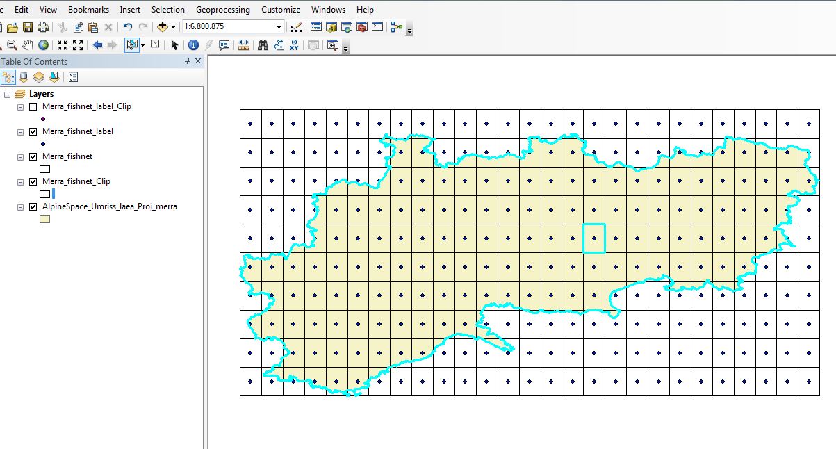
I created a fishnet of a certain extend. See AlpineSpace layer. Now i want to clip all Polygons (Grids) out, that "touch" this layer. Here is the first problem, i don´t know how to to this. i just know how to clip with this .shp. Than i would like to know of each polygon the coordinates. I need it for the right top corner. I know that i could add the xy coordinates for the points, but i would need it for the top right corner of each polygon "touching" the AlpineSpace layer. If i use the "Feature Vertices to points" tool i don´t get the top right corner.
Does annyone know what i mean and how to do it?
Thank you!!
Bests!
- Mark as New
- Bookmark
- Subscribe
- Mute
- Subscribe to RSS Feed
- Permalink
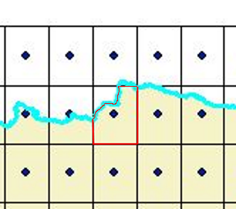
Do you really want to Clip—Help | ArcGIS Desktop the fishnet polygons or maintain them complete (using Select Layer By Location—Help | ArcGIS Desktop and export the selection to a new featureclass). The reason I ask is for the top left coordinate that you are after. How would you define your top right corner for the clipped fishnet polygon marked in red in the example below?
- Mark as New
- Bookmark
- Subscribe
- Mute
- Subscribe to RSS Feed
- Permalink
Dear Xander,
Thanks so much for your answer! It helped a lot! So i managed to clip it with this tool and have now all polygons i need.
I would now need the top right corner coordinates. But just of the grid not of the underliying extend.
So it is the corner of the polygon.
Best regards,
Sophi
- Mark as New
- Bookmark
- Subscribe
- Mute
- Subscribe to RSS Feed
- Permalink
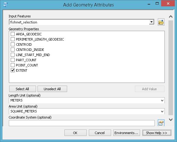
Since the polygons are rectangles with no rotation I guess you could use the Add Geometry Attributes—Help | ArcGIS Desktop tool with the extent option. This will add the following attributes:
- EXT_MIN_X: The minimum x-coordinate of the feature.
- EXT_MIN_Y: The minimum y-coordinate of the feature.
- EXT_MAX_X: The maximum x-coordinate of the feature.
- EXT_MAX_Y: The maximum y-coordinate of the feature.
- Mark as New
- Bookmark
- Subscribe
- Mute
- Subscribe to RSS Feed
- Permalink
Hmm i find the tool and i can run it but than i should have it in the attribute table, right?
There is nothing happening. Like if i run it i don´t get any attributes in the table.
- Mark as New
- Bookmark
- Subscribe
- Mute
- Subscribe to RSS Feed
- Permalink
Strange, if I try this on a fishnet layer:
It returns the fields in the attribute table:
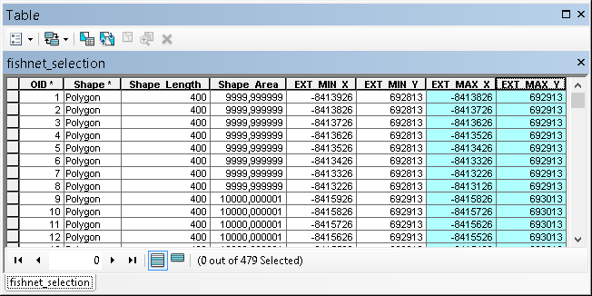
If you want those coordinates as points, you can export the table and use XY events:
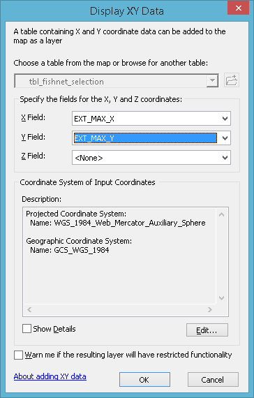
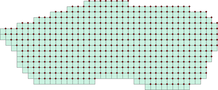
which will generate the points for the upper right corners:
Could you share a sample of your data to have a look?
- Mark as New
- Bookmark
- Subscribe
- Mute
- Subscribe to RSS Feed
- Permalink
So here is my work environments and my session.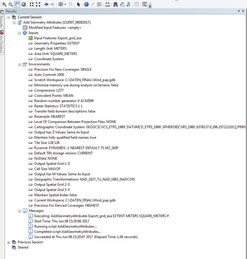
I can sent you the a data set too.
Thanks so much for your support!
- Mark as New
- Bookmark
- Subscribe
- Mute
- Subscribe to RSS Feed
- Permalink
It is strange, no error message, tool runs fine and no attributes added to the featureclass. Where is your data stored? And yes please do attach the data to the thread. To do so, switch on the advanced editor in the reply:

and you will find in the lower right bottom a button to "Attach" files: