- Home
- :
- All Communities
- :
- Products
- :
- Data Management
- :
- Data Management Questions
- :
- Re: How is topology managed in ArcGIS 10x?
- Subscribe to RSS Feed
- Mark Topic as New
- Mark Topic as Read
- Float this Topic for Current User
- Bookmark
- Subscribe
- Mute
- Printer Friendly Page
How is topology managed in ArcGIS 10x?
- Mark as New
- Bookmark
- Subscribe
- Mute
- Subscribe to RSS Feed
- Permalink
In the earlier ArcInfo days, when data was managed as coverages, topology was managed through a series of tables. There was a polygon attribute table (PAT) that stored specific information about the spatial relationships of each polygon, an arc attribute table (AAT) that stored specific information about each arc/line, either for linear features or the features that made up each polygon, and a node attribute table (NAT) that stored specific spatial information about where lines would begin and terminate. There was also a point attribute table (PAT) that contained specific spatial relationship information about point features.
However, now that we're in an ESRI world of geodatabases, how is this topology managed now? Are there perhaps still PAT's, AAT's and NAT's, but they are now in different formats that we can no longer see and access?
Can anyone explain how the ArcGIS geodatabase model (file or personal) keeps track of the spatial relationships in each polygon, arc and node? Is it technically the same as before, and if not, how has this changed?
Thanks
- Mark as New
- Bookmark
- Subscribe
- Mute
- Subscribe to RSS Feed
- Permalink
This pdf from back in the days when geodatabase topology was new (2003) may help in understanding how it differs from ArcInfo topology. It contrasts geodatabase topology with ArcInfo topology to some extent.
The very last paragraph of that pdf states this:
Geodatabase topology stores very little information in the database. Only the parameters of the topology (e,g., participating feature classes, cluster tolerance, relative ranks, and rules), dirty areas, errors, and exceptions are stored. All information is discovered on the fly during the manipulation of the participating feature classes.
Chris Donohue, GISP
- Mark as New
- Bookmark
- Subscribe
- Mute
- Subscribe to RSS Feed
- Permalink
Thanks Chris...this will be an interesting read for sure. Based on what your initial explanation it appears that the geodatabase model is using the same concept as the coverage model, but it is much faster and less taxing because it doesn't permanently store any information.
I'm just double-checking because I'm currently teaching GIS and this topic came up in my lecture material, so I just wanted to make sure that it is still relevant information to convey.
Thanks again
- Mark as New
- Bookmark
- Subscribe
- Mute
- Subscribe to RSS Feed
- Permalink
Back in the day, we captured geology data into coverages. Every line has meaning, every polygon has meaning, and everything hung together really well. Just digitize, clean and build.
Doing the same thing in the geodatabase simple feature classes, even with topology, is really hard.
I know why esri moved away from coverages, scalability, multiple editing, etc, etc. Anyone remember Librarian?
Gee that's going back a bit.
- Mark as New
- Bookmark
- Subscribe
- Mute
- Subscribe to RSS Feed
- Permalink
When we moved from our coverages to geodatabases and the Topology Rules, it was a real learning process. We used the "REGION" feature quite a bit in coverages, and for the Arcs we used the LineID to classifications....that is beside the polygons having to be Built/Clean.
Once Topo-Rules were working, we moved to an SDE GDB (finally massaging and combining about 27 coverages to 3-master polygon databases...which are basically our older REGION features). However, trying to include the Arc layers in to the topology, editing and keeping them all in line was a real disaster. So instead, I recreate the Arc layer from the one non-overlapping polygon FC that is is needed...by running a script I wrote that analyzes the polygon values on the "left" and "right" of the line and assigned the value based on the criteria we had in the coverage. Works well. Not many need this functionality, but for those of use that used all the "bells and whistles" that coverages offered, this was a must for us.
And, as for ArcInfo coverages....The coverage directory really just held pointers to the files that were actually help within the INFO folder....if I remember correctly.
- Mark as New
- Bookmark
- Subscribe
- Mute
- Subscribe to RSS Feed
- Permalink
I remember working with Regions too. Wasn't Arcview 3.x also using Regions? I remember that was our big challenge when moving data from Arcview 3.x into ArcInfo...something of which was resolved with an AML  .
.
That's interesting that you were able to apply the old coverage functionality to the feature class. I may have to visit this myself to see how it can apply. Sounds like a great way to visualize the topology in ArcGIS 10.x.
- Mark as New
- Bookmark
- Subscribe
- Mute
- Subscribe to RSS Feed
- Permalink
Mark,
I think it was because AV 1.0-3x could use coverages...besides the "newly introduced" shapefile format.
Just to show a graphic of what doing this allowed...symbolizing line poly arcs based on the value of the polygon.
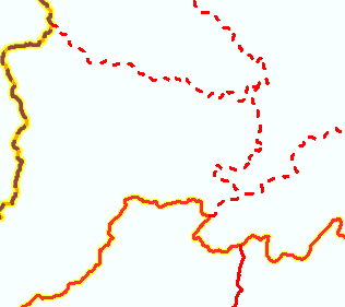

There, of course, has to be some type of logic that you can use. If you ever have a need for something line this, I could probably share the code.. I had to create tables with the attributes I needed from the left and right polys (from my master GDB FC) that I could join (if I remember correctly)....then run thru the logic to decide what code to give them. Helps if you really know your data. Nobody but an old ArcInfo WS would probably even care about this, but pretty cool in my book. I run this about once a month, or whenever I update our services from the master. [all in arcpy/python addin]
- Mark as New
- Bookmark
- Subscribe
- Mute
- Subscribe to RSS Feed
- Permalink
Too funny...I remember using Librarian. It worked fairly well too. If I remember correctly that all went away when ESRI moved into ArcSDE.