Turn on suggestions
Auto-suggest helps you quickly narrow down your search results by suggesting possible matches as you type.
Cancel
- Home
- :
- All Communities
- :
- Products
- :
- Data Management
- :
- Data Management Questions
- :
- Help with showing different LiDAR returns in mosai...
Options
- Subscribe to RSS Feed
- Mark Topic as New
- Mark Topic as Read
- Float this Topic for Current User
- Bookmark
- Subscribe
- Mute
- Printer Friendly Page
Help with showing different LiDAR returns in mosaic dataset?
Subscribe
975
2
12-13-2013 08:52 AM
12-13-2013
08:52 AM
- Mark as New
- Bookmark
- Subscribe
- Mute
- Subscribe to RSS Feed
- Permalink
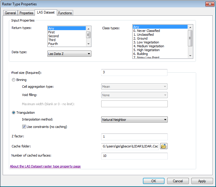
I would like to use a mosaic dataset that contains LiDAR data to show both a first return and bare earth surface. The "LAS Dataset to Raster Function" help file contains the language posted below. I've successfully created a first return surface with a 3-meter cell size using the Raster Type Properties dialog box (attached), but I don't see how I can use caching to show a different return or the ground class only. In other words, how do I get access to the return types and class types to choose what surface I want to show since I've already selected "Any" for both types. I am using the Triangulation radio button to take advantage of the constraints in my .lasd file. Is the parenthetical that says ''no caching" throwing me off? Any help in the process is appreciated as this will eventually be published as a service in ImageServer.
Number of cached surfaces�??The maximum number of caches that can be created using different properties (in this dialog box) for this surface. For example, you might add the LAS dataset to create a surface displaying all the points but you also want to visualize only the points that are classified as ground from the same dataset; therefore, you can create two caches to visualize this data in two ways. Entering a value of 0 will disable caching or clear an existing cache.
............................
The cache will be updated in the following scenarios:
The input has been updated.
The cache has been deleted or is missing.
The function parameters are set to define a different surface than the one that matches the cache (for example, use a different Return type).
2 Replies
12-15-2013
09:21 PM
- Mark as New
- Bookmark
- Subscribe
- Mute
- Subscribe to RSS Feed
- Permalink
... since I've already selected "Any" for both types. I am using the Triangulation radio button to take advantage of the constraints in my .lasd file. Is the parenthetical that says ''no caching" throwing me off? Any help in the process is appreciated as this will eventually be published as a service in ImageServer.
...
Greg,
On our practices with LAS standard 1.1 or higher, those data are usually pre-processed, in particular, noise removal, which is very critical for reliable analysis of LAS data later on.
Secondly, separate /different MDs from individual catalog (class) are created, saying, bare DEM MD, buildings�?? MD, etc; And eventually, cache, when needed�?�
It seems that works fine in ArcGIS 10.2�?�
++++++++++
Just like �??effective�?? noise removal, if LAS data is not compatible with LAS standard 1.1 or higher, the third-party package may be highly required, such as TerraScan or Leica Cyclone, before MD creation.
For LAS standard, pls refer to http://www.asprs.org/Committee-General/LASer-LAS-File-Format-Exchange-Activities.html
12-18-2013
10:02 AM
- Mark as New
- Bookmark
- Subscribe
- Mute
- Subscribe to RSS Feed
- Permalink
Now that I've added rasters to my mosaic dataset, I can access the Raster Type Properties dialog through the function chain to see LiDAR return types and classes again. I've been able to change return types, classes and pixel size to see different views of the data, but I still don't see how this will work with the number of cached surfaces (10 by default) as cached images were not created and zooming/panning remains very slow. Should I be focusing on creating cached images or just rely on overviews to increase performance?
I understand that I can use caching when this gets shared as a service, but for now, I'm just working with the mosaic dataset in ArcMap.
The .las files are 1.3 and I'm working in ArcMap 10.1 SP1.
Thanks!
I understand that I can use caching when this gets shared as a service, but for now, I'm just working with the mosaic dataset in ArcMap.
The .las files are 1.3 and I'm working in ArcMap 10.1 SP1.
Thanks!