- Home
- :
- All Communities
- :
- Products
- :
- Data Management
- :
- Data Management Questions
- :
- Re: Help displaying coordinates from an Excel file...
- Subscribe to RSS Feed
- Mark Topic as New
- Mark Topic as Read
- Float this Topic for Current User
- Bookmark
- Subscribe
- Mute
- Printer Friendly Page
Help displaying coordinates from an Excel file.
- Mark as New
- Bookmark
- Subscribe
- Mute
- Subscribe to RSS Feed
- Permalink
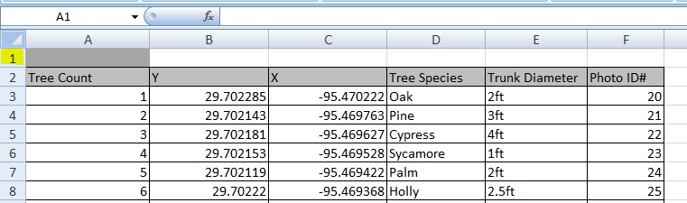
I am working on a map and I am having trouble with it. I was wondering if you all could help me out.. So, I am trying to make a map of trees in a park. I have lat and lon of tree location in decimal degrees, tree count, tree species, trunk diameter, and photo id number in an excel file. I can add the excel file to ArcMap, but I cannot display the X and Y coordinates from the full excel file. However I can display the coordinates if I just add the excel file of the X and Y coordinates. I would like to be able to display the coordinates from the whole excel file so I can use select by attribute and other tools in the table on ArcMap for later purposes. The second problem I am having is when I display the X and Y coordinates from the only X and Y excel file the points are not in the correct area (Bellaire, TX) so I would like to fix that also. The converted graphics points are the correct locations of the trees and I got them from adding the points individually with the go to XY toolbar. Any help would be greatly appreciated. Any problems with the attached files or any other questions let me know. Thank you.
- Mark as New
- Bookmark
- Subscribe
- Mute
- Subscribe to RSS Feed
- Permalink
In an empty data frame add the excel files using the Add XY data tool from arctoolbox, then you need to define the coordinate system of the data using the Define Projection tool (Probably a Geographic Coordinate System WGS84 if from a GPS or maybe one with a NAD83 data for North America).
Longitude is X and Latitude is Y and your data looks correct, BUT ensure that there are absolutely no records that are empty or incomplete and that your longitudes are indeed all negative... one little positive value and you are going to have a mess.
When you have successfully got all the data in the data frame, then introduce other layers as you see fit.
Worry about the other stuff when you have your excel data into a geodatabase with a defined coordinate system (or shapefiles with similar definitions). You other data may be in a projected coordinate system, hence, the mess when you try to add undefined data to a dataframe with a different defined coordinate system.
- Mark as New
- Bookmark
- Subscribe
- Mute
- Subscribe to RSS Feed
- Permalink
or Excel to Table first if you don't want to delete the row
- Mark as New
- Bookmark
- Subscribe
- Mute
- Subscribe to RSS Feed
- Permalink
Open ParkTestFinal.xlsx in MS Excel and delete the first row and save the excel sheet. Now try again (Adding XY data to ArcMap)
Think Location
- Mark as New
- Bookmark
- Subscribe
- Mute
- Subscribe to RSS Feed
- Permalink
Hi John, as Jayanta says above, Delete that extra row in Excel, then re-add your excel file and give it a try.
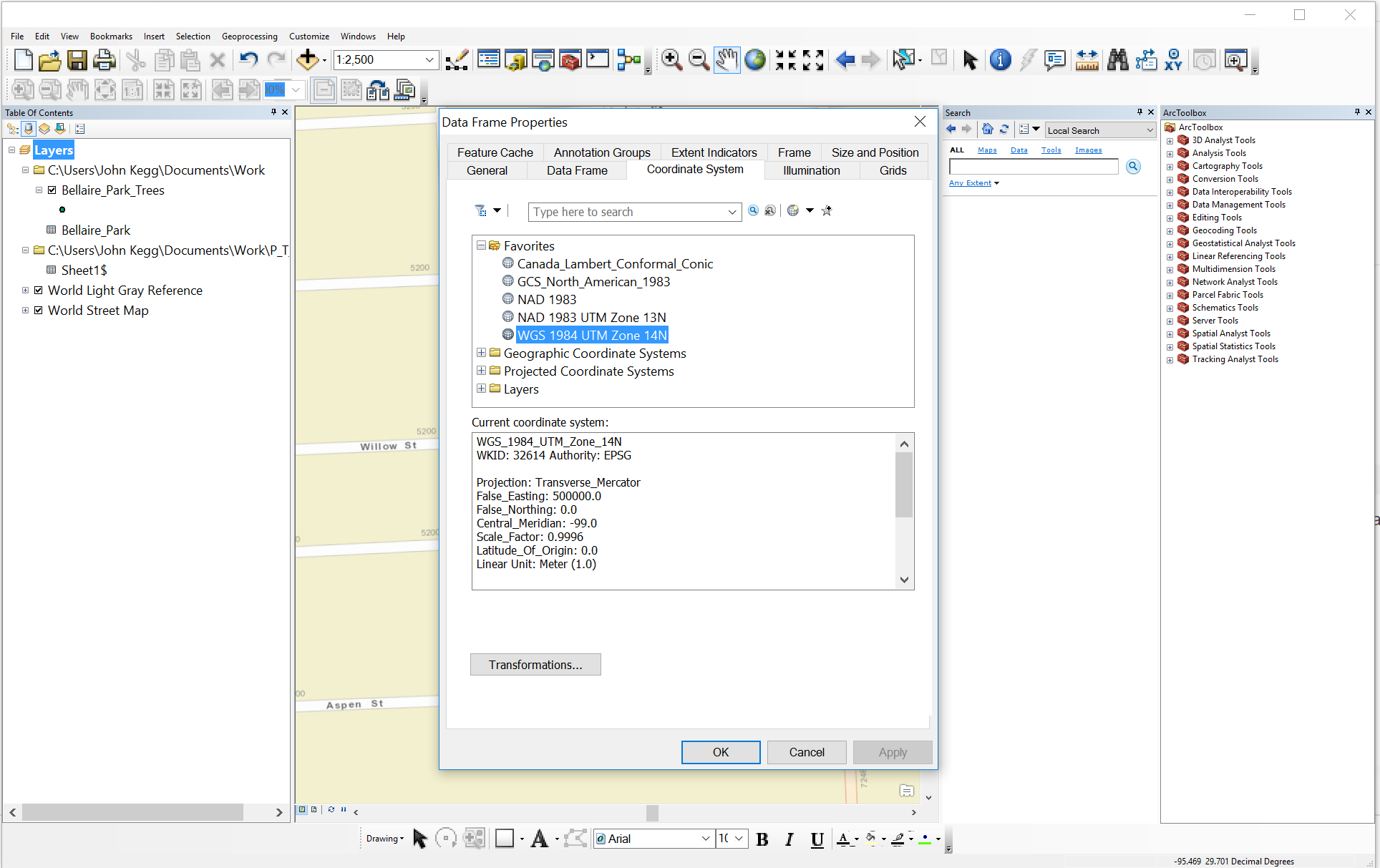
then, also, when you do Display XY data, make sure you change the coordinate system of the XY data to NAD83 since your data is in decimal degrees.
then for more accuracy, go into your data frame properties and in the Coordinate system tab, set up your transformation fro NAD3 to WGS.
I got your points to fall into Bellaire park
- Mark as New
- Bookmark
- Subscribe
- Mute
- Subscribe to RSS Feed
- Permalink
Thank you all very much I greatly appreciate it. I got everything with the Excel file to work thanks to your suggestions. This is the map that ended up with and I wanted to double check with you all to make sure that the data frame and tree layer coordinate systems made sense. Thanks again!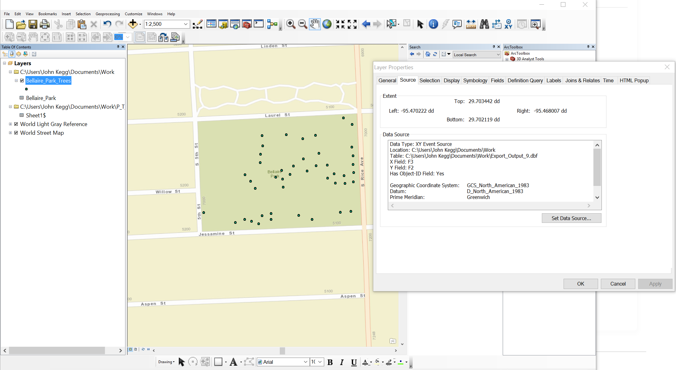
- Mark as New
- Bookmark
- Subscribe
- Mute
- Subscribe to RSS Feed
- Permalink
Looks fine. Although, I wonder what would have happened, had you used GCS_WGS_1984 as the spatial reference while adding XY data (since data frame has WGS_1984 datum).
Just make sure you save the XY Event Source Layer to a shapefile/feature class.
See Step 9 in How To: Import XY data tables to ArcMap and convert the data to a shapefile
Think Location
- Mark as New
- Bookmark
- Subscribe
- Mute
- Subscribe to RSS Feed
- Permalink
I wonder what would have happened, had you used GCS_WGS_1984 as the spatial reference while adding XY data (since data frame has WGS_1984 datum).
If you do not set a transformation in the Data Frame properties / XY Coordinate dialog, no transformation will take place, and your points may be plotted slightly shifted (NAD83 and WGS84 are very close so the shift would likely be sub-meter in size).
A long time ago (< 10.1?) ArcMap would guess a transform in some situations, now it just gives you a warning when you add the data and leaves it up to you to worry about datum transformations.