- Home
- :
- All Communities
- :
- Products
- :
- Data Management
- :
- Data Management Questions
- :
- GP Tools for LAS edit and outlines detection
- Subscribe to RSS Feed
- Mark Topic as New
- Mark Topic as Read
- Float this Topic for Current User
- Bookmark
- Subscribe
- Mute
- Printer Friendly Page
GP Tools for LAS edit and outlines detection
- Mark as New
- Bookmark
- Subscribe
- Mute
- Subscribe to RSS Feed
- Permalink
Hey, guys
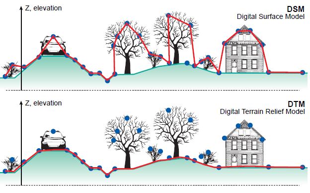
Many of our LAS data (which were not processed/ classified by the data vendors) urgently need edit and clean up, in particular, detection and removal of massive ‘outlines’. After well done in this way, we expect that the results of LAS data can well represent DSM (digital surface model). Of course, those DSM will be used to do further processing and analysis.
The question is:
In ArcGIS, any effective GP tools can be used to assist us to meet this goal?
Ideally, a GP tool that utilizes RANSAC algorithm (random sample consensus) is available. If not, any alternatives?
Please advice
- Mark as New
- Bookmark
- Subscribe
- Mute
- Subscribe to RSS Feed
- Permalink
In general, the UI and GP tools in ArcGIS are meant to be used with classified airborn Lidar data. Especially the simple editing features are basically meant to change the classification or select/delete points.
The ArcGIS documentation has examples for several workflows: Transfer building height, find outliers (QA/QC), ... one of the latest improvements is a method to derive ground points ... I have not used it ...
If you want to do mass classification and analysis of unclassified LAS you still most likely have to use specific LIDAR solutions.
- Mark as New
- Bookmark
- Subscribe
- Mute
- Subscribe to RSS Feed
- Permalink
Thanks Gunter,
Please help provide ArcGIS Documentation link that shows a way to find out outlines in LAS (QA/QC).
To get a well-processed DSM data (rather than DEM/DTM or normalized DSM) from those old & poor LAS point cloud is our major goal.
Regards
- Mark as New
- Bookmark
- Subscribe
- Mute
- Subscribe to RSS Feed
- Permalink
In the online help for 10.5 look here for the analysis descriptions:
- Mark as New
- Bookmark
- Subscribe
- Mute
- Subscribe to RSS Feed
- Permalink
Thanks for the link.
It looks that we need more time to explore all those GP utilities and workflows for efficiently pre-processing LAS datasets in ArcGIS, including Locate Outliers ...
Until now, ArcGIS have offered many effective GP tools and workflows to help enterprise customers to deal with 'well-processed & well-organized' LAS point cloud, including 'manage, use, analyze LAS data, even extract DEM and building roofs from LAS data'.
Hopefully, ArcGIS users will see some efforts from ESRI to help effectively pre-process LAS point cloud soon ...