- Home
- :
- All Communities
- :
- Products
- :
- Data Management
- :
- Data Management Questions
- :
- Geocode streets with address range 0 - 0 (ArcGIS 1...
- Subscribe to RSS Feed
- Mark Topic as New
- Mark Topic as Read
- Float this Topic for Current User
- Bookmark
- Subscribe
- Mute
- Printer Friendly Page
Geocode streets with address range 0 - 0 (ArcGIS 10.2.1)
- Mark as New
- Bookmark
- Subscribe
- Mute
- Subscribe to RSS Feed
- Permalink
Hello,
I am trying to figure out how to rework my Address Locator or my reference data such that it will return candidates for street segments that have address ranges of 0 - 0 without having to type "0 A ST" for example.
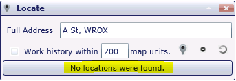
If I type "A St, WROX" (for street name and zone) then I get no results. (This A St does not have any residences or addresses)
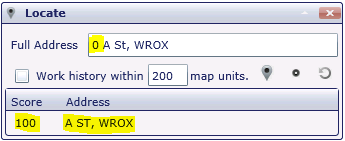
However, if I add a "0" in front of the street for an address number, it gives me a 100 match to "A ST, WROX" and strips off the 0 in the match address. Lowering the minimum candidate score does not help.
Any ideas??
Thanks,
David
- Mark as New
- Bookmark
- Subscribe
- Mute
- Subscribe to RSS Feed
- Permalink
As a conversation starter: which segment of A st does the geocoder match it to when you add the 0(zero) ?
I have plenty of streets that don't have physical addresses assigned to them, but every segment has a range. (Think freeways: they have a range even if it's based on mile post values and not a single physical address.)
How important is your spatial accuracy/precision when you geocode the phantom addresses, and how many do you have? I wonder if you could just create a set of points that would have A ST, WROX as the matching element and that would work for you. Like a place names sort of feature class. No 'real' address, just a point to match it to.
An alternative is to create a streets feature class of named streets all merged on the street name. Then you could use a US Streets Street Name type of locator. I've never used one because the work I do (9-1-1 dispatch) requires a much higher level of precision with respect to the geocoded result.
- Mark as New
- Bookmark
- Subscribe
- Mute
- Subscribe to RSS Feed
- Permalink
Hi Joe,
Thanks for your reply. Continuing with the A St, WROX example, adding the 0 yields three candidates with 100 score matches. This is because there are three street centerline segments that have the 0 - 0 range, so I believe it is just matching it to the first of the three, not sure how it's choosing which of the three 100 scores to be at the top of the list.
I am preparing for a transition to using Cityworks as a work order management system, so the accuracy of the geocoding is pretty important. There are lots of Public Alleys in Boston that do not have addresses, but there are catch basins and other assets that will have maintenance work orders attached to them, so the yard clerks will need an easy way to geocode and locate the nearby assets quickly. The Public Alley is a similar example because the way the street centerline data and geocoder are set up now, it requires a 0 to be added up front for a match to be found.
I will certainly look into the US Streets Street Name locator type, but it might be helpful to populate all the zero ranges moving forward, to improve accuracy. We have ~172,000 street centerline segments in Boston, and about 4,500 have 0 - 0 address ranges, so less than 3%.
- Mark as New
- Bookmark
- Subscribe
- Mute
- Subscribe to RSS Feed
- Permalink
Joe,
What's a zero - zero address range used for?
I see it is included in the NG911 GIS standards for parity left/right as Odd/Even/Both/Zero.
- Mark as New
- Bookmark
- Subscribe
- Mute
- Subscribe to RSS Feed
- Permalink
There seems to be 4+ years between posts so my response tracks within that schedule. Ha! David's (OP) user account appears to be deactivated so this won't help him but I'll respond to his public alley geocoding of assets. I'll also give a possible answer to Bill's question of what a 0 - 0 address range is used for... Just in case someone is searching and wants possible ideas.
Regarding the alleys, even though we don't address structures from them, I still give them the same address range as the streets parallel to them (i.e. they have the same block range). Just because a street segment has a from/to range doesn't mean you must address something to it. It's simply a reference. FWIW, we also named our alleys with a reference to the "bounding streets" for that segment, since alleys exist between multiple streets in parallel. So, for an East-West running alley, the name would be "ALLEY {street name to the North} {street name to the South}" (ex. ALLEY BIRCH ALDER). No need to get fancy with a fully qualified street name. As for which segment of alley you are talking about, that is taken care of with the address range.
Regarding 0 - 0 address ranges, the only time I use them is for Driveway segments. We have homes that can't be seen from the street and/or are on long driveways. Simply seeing where the address point is doesn't necessarily indicate how you get to them. So the driveway segments are mainly referential (I use a dashed line symbol) and do not break the street segment. But all street segments in the dataset need an address range so they all get from/to ranges equal to zero. And parity, thus, is zero.
Just a couple of examples of how one user is handling those sorts of things. There are likely multiple possible solutions depending on how you want to operate.