Turn on suggestions
Auto-suggest helps you quickly narrow down your search results by suggesting possible matches as you type.
Cancel
- Home
- :
- All Communities
- :
- Products
- :
- Data Management
- :
- Data Management Questions
- :
- Error: �??the coordinates or measure are out of bo...
Options
- Subscribe to RSS Feed
- Mark Topic as New
- Mark Topic as Read
- Float this Topic for Current User
- Bookmark
- Subscribe
- Mute
- Printer Friendly Page
Error: �??the coordinates or measure are out of bound�?�,
Subscribe
4859
6
04-23-2014 11:12 AM
04-23-2014
11:12 AM
- Mark as New
- Bookmark
- Subscribe
- Mute
- Subscribe to RSS Feed
- Permalink
Error: â??the coordinates or measure are out of boundâ?�,
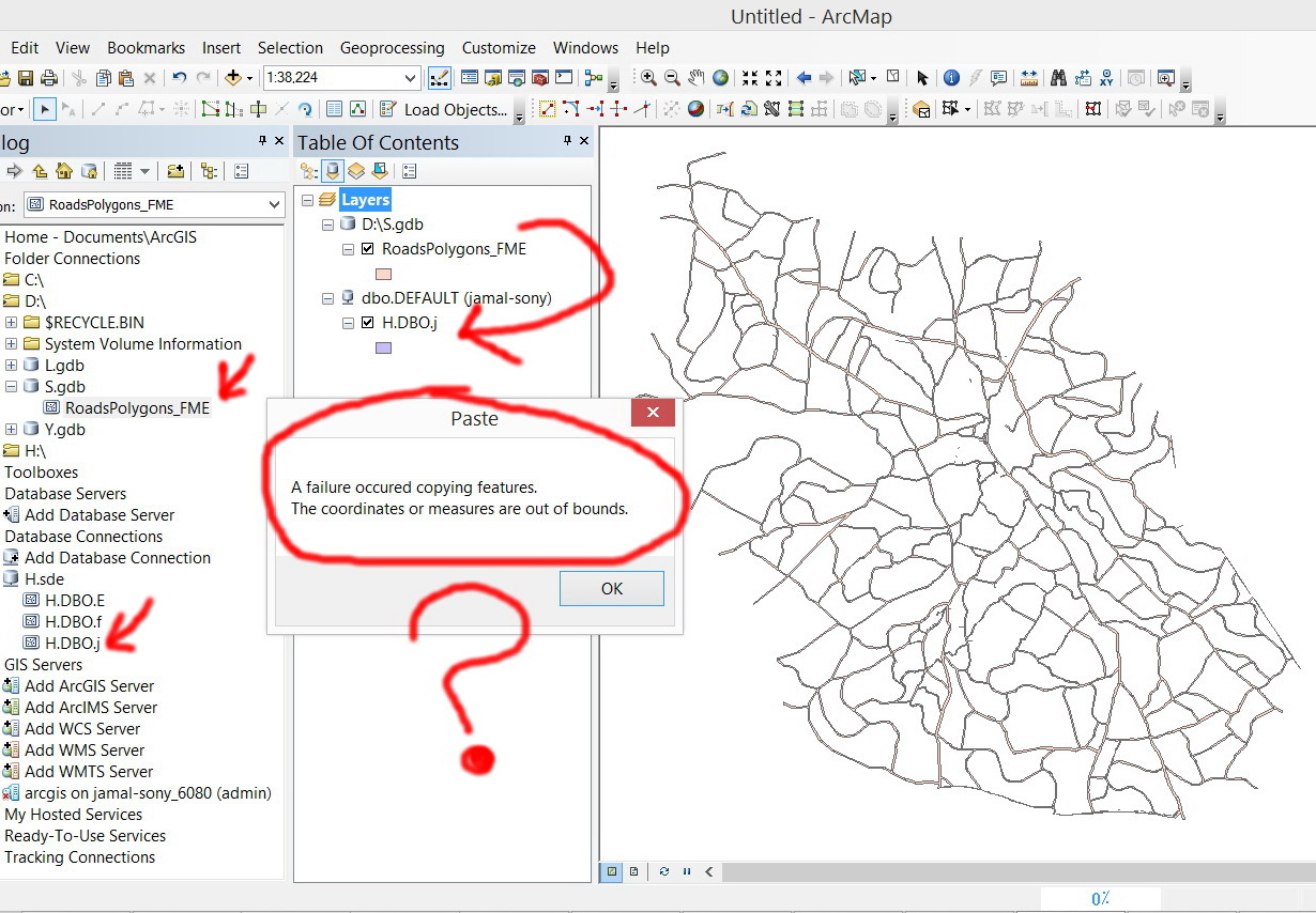
I wanted to copy features from file geodatabase layer (attached) to enterprise geodatabase layer but I got the error below (knowing that the source and destination layers have the same coordinate system).
[ATTACH=CONFIG]33287[/ATTACH], [ATTACH=CONFIG]33288[/ATTACH], [ATTACH=CONFIG]33289[/ATTACH]
What might be the issue here?
Thank you
Best
Jamal
----------------------------------------
Jamal Numan
Geomolg Geoportal for Spatial Information
Ramallah, West Bank, Palestine
Jamal Numan
Geomolg Geoportal for Spatial Information
Ramallah, West Bank, Palestine
6 Replies
04-23-2014
11:34 AM
- Mark as New
- Bookmark
- Subscribe
- Mute
- Subscribe to RSS Feed
- Permalink
Jamal,
I noticed that in the third image (from the SDE geodatabase) that there are not feature extent coordinates (Top, bottom, left and right). The the second image (from the file geodatabase) has feature extent coordinates. That may be a direction to look into. I did see that the projections are the same.
Just an observation......
George
--- George T.
by
Anonymous User
Not applicable
04-23-2014
11:45 AM
- Mark as New
- Bookmark
- Subscribe
- Mute
- Subscribe to RSS Feed
- Permalink
Original User: Jamal432@gmail.com
Thanks George.
This is how the ArcGIS behaves by default as new enterprise geodatabse layer is created. It doesn�??t give an extent.
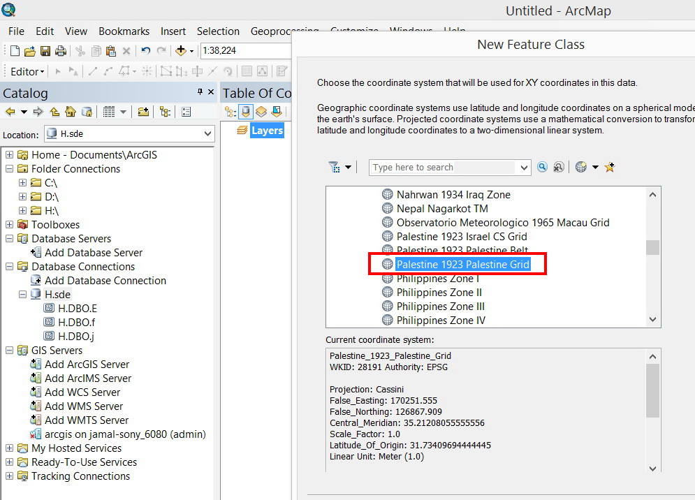
[ATTACH=CONFIG]33291[/ATTACH],[ATTACH=CONFIG]33292[/ATTACH], [ATTACH=CONFIG]33293[/ATTACH], [ATTACH=CONFIG]33294[/ATTACH], [ATTACH=CONFIG]33295[/ATTACH]
Could you please try to create enterprise geodatabse layer at your machine? does it give an extent?
Jamal,
I noticed that in the third image (from the SDE geodatabase) that there are not feature extent coordinates (Top, bottom, left and right). The the second image (from the file geodatabase) has feature extent coordinates. That may be a direction to look into. I did see that the projections are the same.
Just an observation......
George
Thanks George.
This is how the ArcGIS behaves by default as new enterprise geodatabse layer is created. It doesn�??t give an extent.
[ATTACH=CONFIG]33291[/ATTACH],[ATTACH=CONFIG]33292[/ATTACH], [ATTACH=CONFIG]33293[/ATTACH], [ATTACH=CONFIG]33294[/ATTACH], [ATTACH=CONFIG]33295[/ATTACH]
Could you please try to create enterprise geodatabse layer at your machine? does it give an extent?
04-23-2014
12:09 PM
- Mark as New
- Bookmark
- Subscribe
- Mute
- Subscribe to RSS Feed
- Permalink
Jamal,
I tested in SQL Server and Oracle and got a different message when copying/pasting into the feature class in either. See attached screenshot. This error seems related to the other forum post that you have.
My process was: Start an edit session, open the file geodatabase feature class table, select all features, copy, then paste into the SDE feature class.
Hope this helps.....
George
--- George T.
by
Anonymous User
Not applicable
04-23-2014
12:49 PM
- Mark as New
- Bookmark
- Subscribe
- Mute
- Subscribe to RSS Feed
- Permalink
Original User: Jamal432@gmail.com
Thanks George for the help,
I�??m wondering why you have different error message. I�??m using SQL database as well
What might be the issue then?
Jamal,
I tested in SQL Server and Oracle and got a different message when copying/pasting into the feature class in either. See attached screenshot. This error seems related to the other forum post that you have.
My process was: Start an edit session, open the file geodatabase feature class table, select all features, copy, then paste into the SDE feature class.
Hope this helps.....
George
Thanks George for the help,
I�??m wondering why you have different error message. I�??m using SQL database as well
What might be the issue then?
04-24-2014
03:52 AM
- Mark as New
- Bookmark
- Subscribe
- Mute
- Subscribe to RSS Feed
- Permalink
I am wondering if it has to do with the fact that most of the roads are a single polygon and it is creating the errors. There are also a bunch of very small polygons that barely have geometry to them. I think that they may get collapsed when loaded into the SQL geodatabase as part of the check when loading data.
I have read you other post (http://forums.arcgis.com/threads/107598-Error-�??line-string-or-poly-boundary-is-self-intersecting�?...) and think that these issues are all related.
What is you try to split the massive road polygon into smaller pieces for loading?
I have read you other post (http://forums.arcgis.com/threads/107598-Error-�??line-string-or-poly-boundary-is-self-intersecting�?...) and think that these issues are all related.
What is you try to split the massive road polygon into smaller pieces for loading?
--- George T.
by
Anonymous User
Not applicable
04-24-2014
09:39 AM
- Mark as New
- Bookmark
- Subscribe
- Mute
- Subscribe to RSS Feed
- Permalink
Original User: Jamal432@gmail.com
Thanks George,
I never know that an internal checks are applied when copy and paste features from a layer to other. I thought that such checks are applied in purpose when building �??topology�?� with rules, for example. As these features are living currently in enterprise geodatabase layer is expected to be sufficient to be copied to other layer successfully.
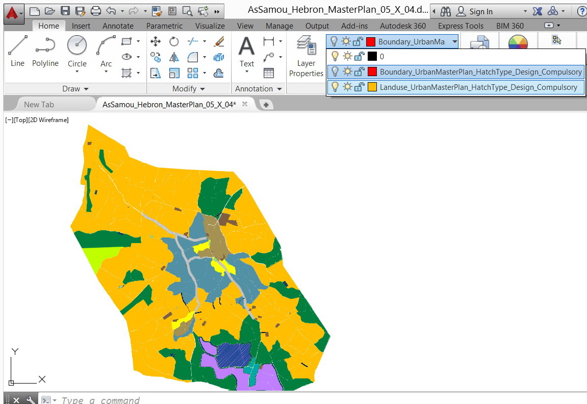
These roads are derived from CAD files (one file is attached). We use the FME to convert the CAD hatches to polygons (ArcGIS fails to read hatches).
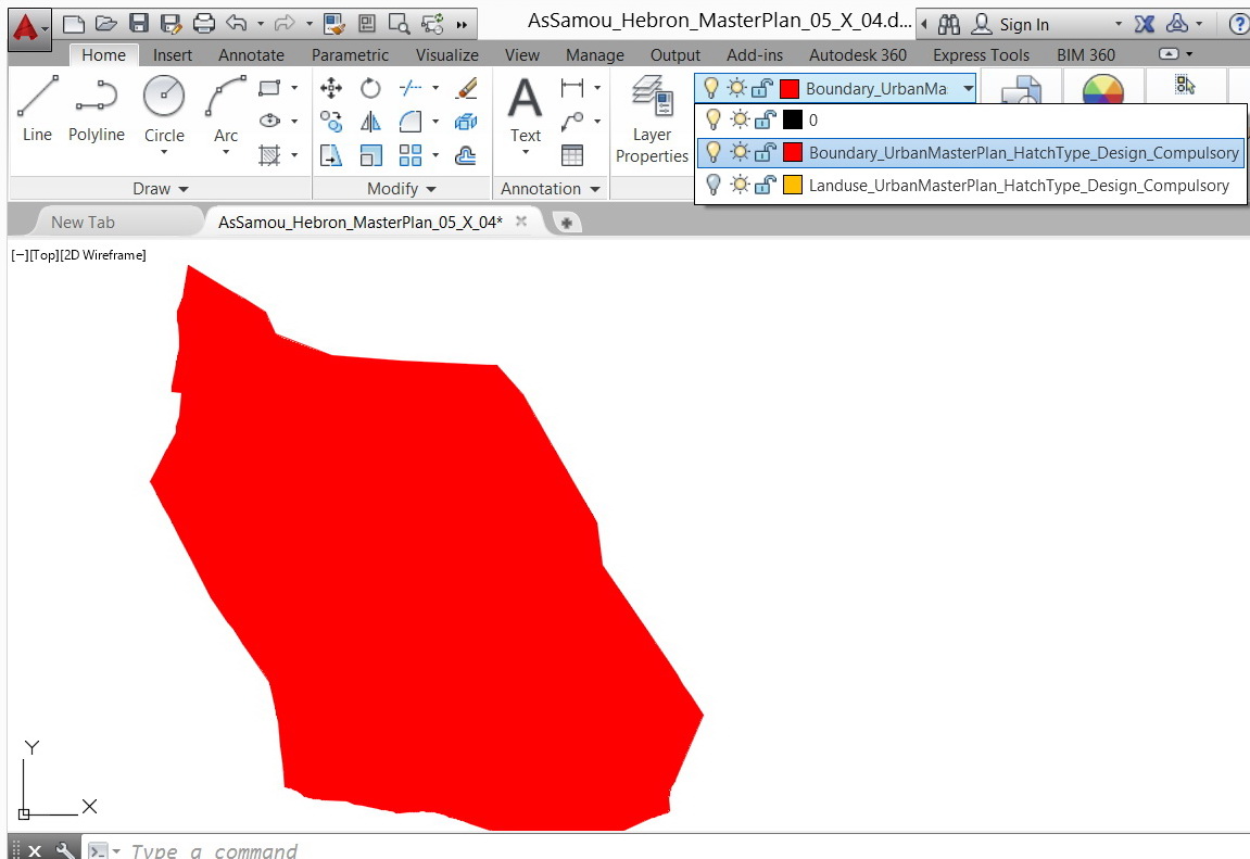
1. Boundary layer (one polygon)
[ATTACH=CONFIG]33344[/ATTACH]
2. Landuse layer (multiple polygons)
[ATTACH=CONFIG]33345[/ATTACH]
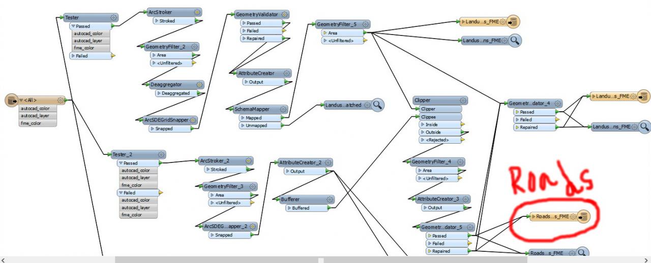
3. The roads are derived by subtracting the Landuse layer from Boundary layer by FME workbench
[ATTACH=CONFIG]33346[/ATTACH]
[ATTACH=CONFIG]33347[/ATTACH]
These features of road layer are fine at the level of FILE GEODATABASE. Issues appear as they are copied and pasted to ENTERPRISE GEODATABASE LAYER
I am wondering if it has to do with the fact that most of the roads are a single polygon and it is creating the errors. There are also a bunch of very small polygons that barely have geometry to them. I think that they may get collapsed when loaded into the SQL geodatabase as part of the check when loading data.
I have read you other post (http://forums.arcgis.com/threads/107598-Error-�??line-string-or-poly-boundary-is-self-intersecting�?...) and think that these issues are all related.
What is you try to split the massive road polygon into smaller pieces for loading?
Thanks George,
I never know that an internal checks are applied when copy and paste features from a layer to other. I thought that such checks are applied in purpose when building �??topology�?� with rules, for example. As these features are living currently in enterprise geodatabase layer is expected to be sufficient to be copied to other layer successfully.
These roads are derived from CAD files (one file is attached). We use the FME to convert the CAD hatches to polygons (ArcGIS fails to read hatches).
1. Boundary layer (one polygon)
[ATTACH=CONFIG]33344[/ATTACH]
2. Landuse layer (multiple polygons)
[ATTACH=CONFIG]33345[/ATTACH]
3. The roads are derived by subtracting the Landuse layer from Boundary layer by FME workbench
[ATTACH=CONFIG]33346[/ATTACH]
[ATTACH=CONFIG]33347[/ATTACH]
These features of road layer are fine at the level of FILE GEODATABASE. Issues appear as they are copied and pasted to ENTERPRISE GEODATABASE LAYER