Turn on suggestions
Auto-suggest helps you quickly narrow down your search results by suggesting possible matches as you type.
Cancel
- Home
- :
- All Communities
- :
- Products
- :
- Data Management
- :
- Data Management Questions
- :
- Re: Error in interpreation of curves
Options
- Subscribe to RSS Feed
- Mark Topic as New
- Mark Topic as Read
- Float this Topic for Current User
- Bookmark
- Subscribe
- Mute
- Printer Friendly Page
Error in interpreation of curves
Subscribe
2635
8
05-01-2013 12:12 PM
05-01-2013
12:12 PM
- Mark as New
- Bookmark
- Subscribe
- Mute
- Subscribe to RSS Feed
- Permalink
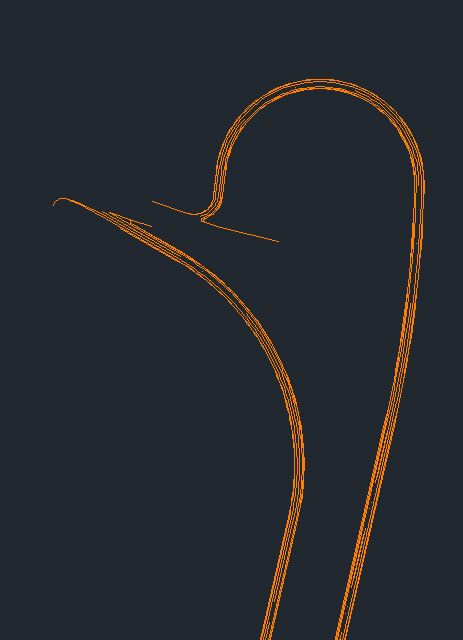
I have several planimetric Autocad dwgs that contain polylines with curves that are not correctly interpreted when viewed in ArcGIS 10.1. The symptom can be seen in the attached image. The problem persists if I save the dwg as any dwg version from R14 thru 2010.
A collegue sees the same problem when using ArcGIS 10.0 SP1.
[ATTACH=CONFIG]23910[/ATTACH]
Has anyone had this issue with CAD dwgs? Is there a fix on the way?
So far, the only work around is to export to a shapefile from Autocad. Exporting Data from ArcGIS preserves the spurious data.
Many thanks in advance,
Bill
8 Replies
05-02-2013
05:41 AM
- Mark as New
- Bookmark
- Subscribe
- Mute
- Subscribe to RSS Feed
- Permalink
In AutoCAD they are called Splines. They are a serious pain in the buttock.
Try this on a copy of the CAD dwg
Go to the CAD drawing and perform build and clean.
Do a query to select all splines and explode them. IT should turn them into simple polylines
The do build and clean again.
I have converted a lot of AutoCAD drawings to ArcGIS and it is a recurring issue.
Try this on a copy of the CAD dwg
Go to the CAD drawing and perform build and clean.
Do a query to select all splines and explode them. IT should turn them into simple polylines
The do build and clean again.
I have converted a lot of AutoCAD drawings to ArcGIS and it is a recurring issue.
I have several planimetric Autocad dwgs that contain polylines with curves that are not correctly interpreted when viewed in ArcGIS 10.1. The symptom can be seen in the attached image. The problem persists if I save the dwg as any dwg version from R14 thru 2010.
A collegue sees the same problem when using ArcGIS 10.0 SP1.
[ATTACH=CONFIG]23910[/ATTACH]
Has anyone had this issue with CAD dwgs? Is there a fix on the way?
So far, the only work around is to export to a shapefile from Autocad. Exporting Data from ArcGIS preserves the spurious data.
Many thanks in advance,
Bill
05-03-2013
08:20 AM
- Mark as New
- Bookmark
- Subscribe
- Mute
- Subscribe to RSS Feed
- Permalink
Can you attach a sample drawing? I'll take a look at them and see if I can see/fix what's happening. It is always a good idea to contact technical support with things like this...they'll log the issue and make sure development sees it and fixes it.
I have several planimetric Autocad dwgs that contain polylines with curves that are not correctly interpreted when viewed in ArcGIS 10.1. The symptom can be seen in the attached image. The problem persists if I save the dwg as any dwg version from R14 thru 2010.
A collegue sees the same problem when using ArcGIS 10.0 SP1.
[ATTACH=CONFIG]23910[/ATTACH]
Has anyone had this issue with CAD dwgs? Is there a fix on the way?
So far, the only work around is to export to a shapefile from Autocad. Exporting Data from ArcGIS preserves the spurious data.
Many thanks in advance,
Bill
05-08-2013
01:33 PM
- Mark as New
- Bookmark
- Subscribe
- Mute
- Subscribe to RSS Feed
- Permalink
Hi, I am having a similar issue...where you able to find a solution / work around?
I am converting Microstation road designs into GIS (via autocad, to scale and verify they are projected correctly, which they are). The linework is correct in autocad (see correct.jpg) but when I export it to GIS (I tried multiple ways, as well as trying to import it via Arcmap which was less successful) a significant portion of the line work has shifted.
Did you ever hear back from ESRI?
Thanks!
[ATTACH=CONFIG]24142[/ATTACH]
[ATTACH=CONFIG]24143[/ATTACH]
05-08-2013
11:31 PM
- Mark as New
- Bookmark
- Subscribe
- Mute
- Subscribe to RSS Feed
- Permalink
Are you able to attach a sample DGN? I'd be glad to see how it looks in the upcoming release.
Hi, I am having a similar issue...where you able to find a solution / work around?
I am converting Microstation road designs into GIS (via autocad, to scale and verify they are projected correctly, which they are). The linework is correct in autocad (see correct.jpg) but when I export it to GIS (I tried multiple ways, as well as trying to import it via Arcmap which was less successful) a significant portion of the line work has shifted.
Did you ever hear back from ESRI?
Thanks!
[ATTACH=CONFIG]24142[/ATTACH]
[ATTACH=CONFIG]24143[/ATTACH]
05-09-2013
07:22 AM
- Mark as New
- Bookmark
- Subscribe
- Mute
- Subscribe to RSS Feed
- Permalink
Unfortonetly, when I try to attached the dgn/dwg I keep getting an error. Do you have any tips on attaching those files?
Are you able to attach a sample DGN? I'd be glad to see how it looks in the upcoming release.
05-09-2013
10:14 AM
- Mark as New
- Bookmark
- Subscribe
- Mute
- Subscribe to RSS Feed
- Permalink
You'll need to put the DGN/DWG into a ZIP file to attach to a forum message.
Valid file extensions: 7z doc docx eaz ecp esriaddin esu9 gif gz jpeg jpg lpk mpk msd mxd nmf pdf png py rar tar txt xls xlsx zip
Valid file extensions: 7z doc docx eaz ecp esriaddin esu9 gif gz jpeg jpg lpk mpk msd mxd nmf pdf png py rar tar txt xls xlsx zip
Unfortonetly, when I try to attached the dgn/dwg I keep getting an error. Do you have any tips on attaching those files?
05-14-2013
02:00 PM
- Mark as New
- Bookmark
- Subscribe
- Mute
- Subscribe to RSS Feed
- Permalink
Good news! (Well, maybe just "so-so" news.)
I tested your dgn in the upcoming release and it looks lovely. Just like you want it to.
Unfortunately, that doesn't help you much today. The problem entities are elliptical arcs, not splines. (I'm really not sure why, but ellipses cause me no end of grief.) You could probably go back into the dgn and smooth the ellipses into splines and it would probably work.
Not much help, I know, but at least you know it is fixed in the future.
Thank you!