- Home
- :
- All Communities
- :
- Products
- :
- Data Management
- :
- Data Management Questions
- :
- Re: erase tool while heads up digitizing
- Subscribe to RSS Feed
- Mark Topic as New
- Mark Topic as Read
- Float this Topic for Current User
- Bookmark
- Subscribe
- Mute
- Printer Friendly Page
- Mark as New
- Bookmark
- Subscribe
- Mute
- Subscribe to RSS Feed
- Permalink
Hello,
I'm wondering if anyone knows of a third party tool or something built into ArcGIS 10x that will erase or clip an area of a polygon quickly and efficiently. I'm thinking something like the 'magic eraser tool' in Photoshop. I'm trying to manually digitize sand within reef communities and as it stands I'm digitizing a polygon over-top of the the wider 'reef' polygon and then clipping the underlying data... all the while thinking that there has to be a better way of doing it as there are many areas. These are areas where image classification isn't working out well.
Any thoughts are appreciated thank you.
Solved! Go to Solution.
Accepted Solutions
- Mark as New
- Bookmark
- Subscribe
- Mute
- Subscribe to RSS Feed
- Permalink
Make a donut and dump the hole as has been suggested earlier
- Mark as New
- Bookmark
- Subscribe
- Mute
- Subscribe to RSS Feed
- Permalink
Have you tried the Erase (Anaylsis) tool ArcGIS Help 10.1- Erase
It's in the 'Analysis Tools' -->'Overlay' toolbox
- Mark as New
- Bookmark
- Subscribe
- Mute
- Subscribe to RSS Feed
- Permalink
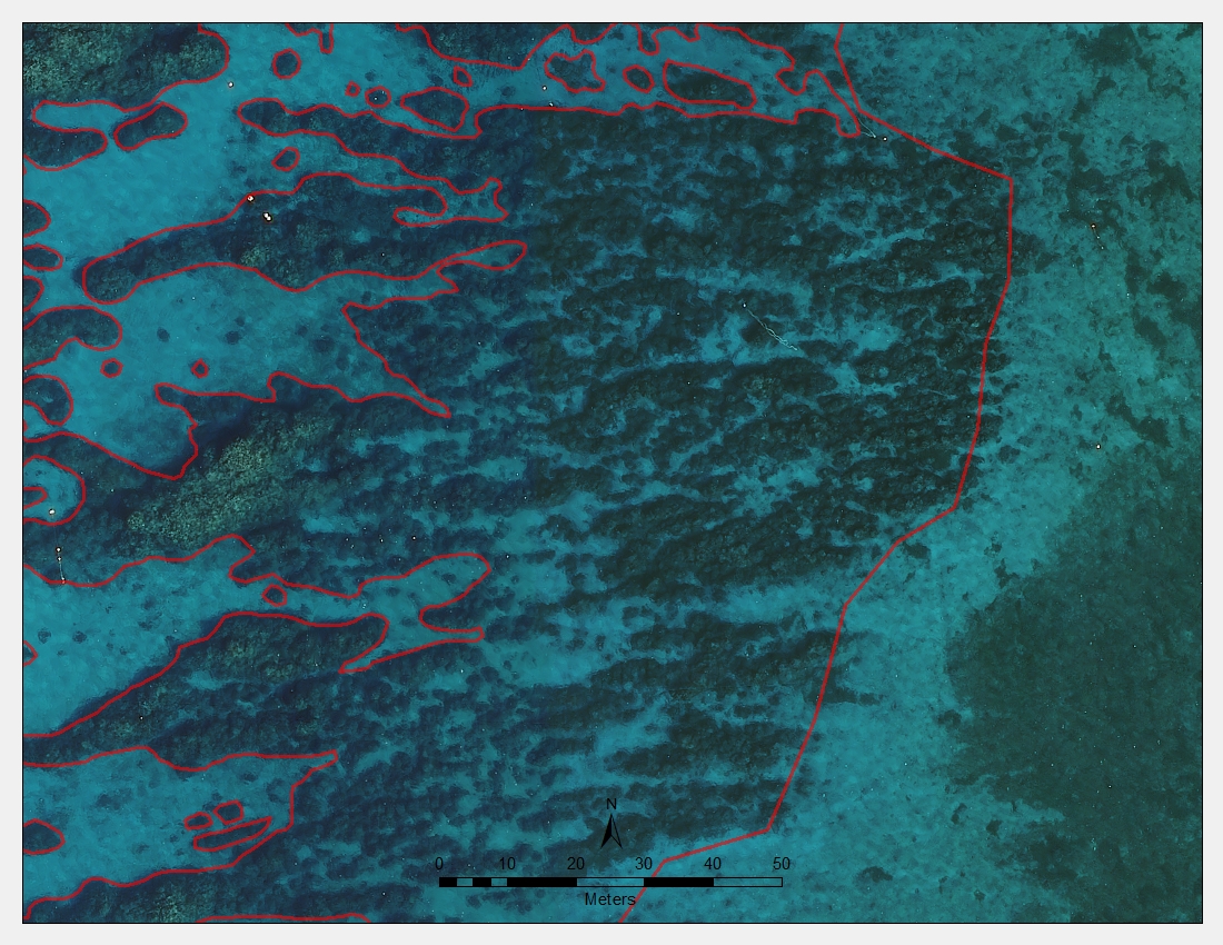
Thanks for the reply Mitch. I don't have the two layers separated as yet but if I did then I would use the erase tool for that for sure. Here is an example of what I'm trying to separate.
- Mark as New
- Bookmark
- Subscribe
- Mute
- Subscribe to RSS Feed
- Permalink
Not sure if this helps you at all, but check out the polygon editing tools of ET Geo Tools:
The concept of Polygon editing
There are some tools that will make your polygon editing work flow a bit easier...
- Mark as New
- Bookmark
- Subscribe
- Mute
- Subscribe to RSS Feed
- Permalink
Thanks Chris. It looks like the polygon editing tool isn't available in the free version of ET GeoTools. Also, I tried using it and it looks like there is no 'streaming vertices' available when editing so it would be difficult to digitize multiple polygons. I do use ET GeoWizards often and can recommend that as well for geoprocessing.
- Mark as New
- Bookmark
- Subscribe
- Mute
- Subscribe to RSS Feed
- Permalink
Jeremy,
Not sure exactly if it fits your need but ArcMap does have the ability to do an interactive clip while editing.
- Start your editing session
- Select the features you want to clip out of your polygon
- Slick the Editor button on the Edit tool bar
- Select Clip from the list
- Choose Discard the area that intersects on the Clip dialog
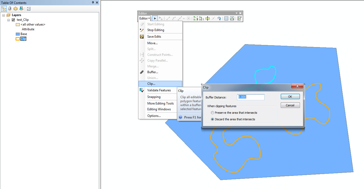
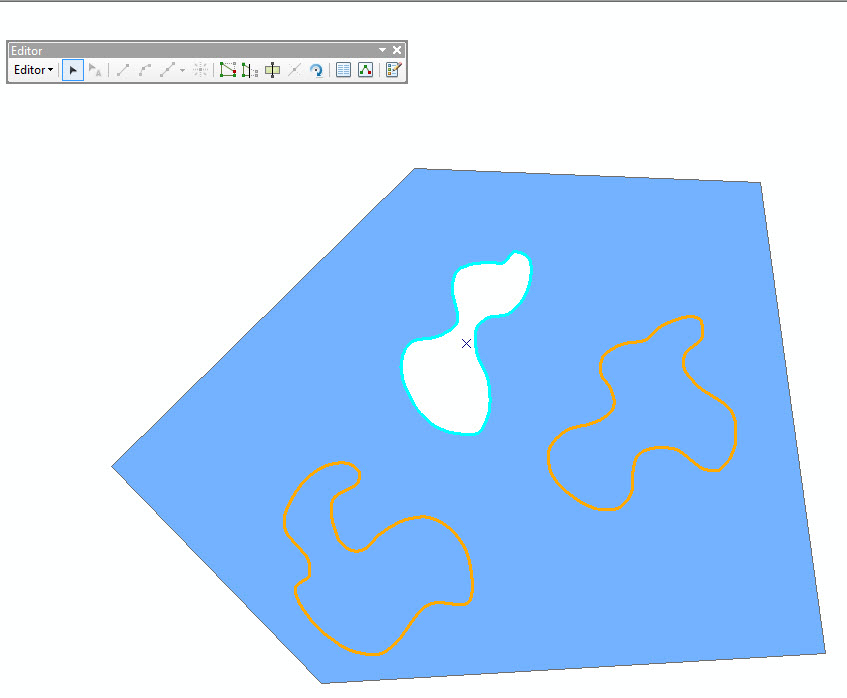
And then the result
- Mark as New
- Bookmark
- Subscribe
- Mute
- Subscribe to RSS Feed
- Permalink
Thanks Kyle - yeah, that's what I've been doing thus far. I'm creating a new polygon using streaming vertices and then using the clip function on the editor toolbar. It does work although I was hoping to avoid the need to 'clip' the background polygon somehow to speed up the process. If there was some kind of 'eraser' of the background polygon using a brush of a certain width, I think that would be ideal. It is possible that it just doesn't exist!
- Mark as New
- Bookmark
- Subscribe
- Mute
- Subscribe to RSS Feed
- Permalink
It doesn't exist (as far as I know) if you are working with vector data...just goes against the structure of the data model. There is a Raster Painting option in ArcMap that you might take a look at and see if you can use it in conjunction with the output of an image classification.
I feel your pain...I have digitized large forested areas for several custom maps I have created in the past.
- Mark as New
- Bookmark
- Subscribe
- Mute
- Subscribe to RSS Feed
- Permalink
Yeah, that makes sense. I think even if there was a script tied to a new polygon where it took priority over everything behind it and automatically clipped the underlying polygon. This way I wouldn't have to select clip every time.
- Mark as New
- Bookmark
- Subscribe
- Mute
- Subscribe to RSS Feed
- Permalink
Jeremy,
Try using the 'Extract by Mask' (Spatial Analyst) tool. ArcGIS Help 10.1- Extract by Mask
If that red line is a feature class. This tool will work perfectly