Turn on suggestions
Auto-suggest helps you quickly narrow down your search results by suggesting possible matches as you type.
Cancel
- Home
- :
- All Communities
- :
- Products
- :
- Data Management
- :
- Data Management Questions
- :
- Doubt about my geo referencing procedure
Options
- Subscribe to RSS Feed
- Mark Topic as New
- Mark Topic as Read
- Float this Topic for Current User
- Bookmark
- Subscribe
- Mute
- Printer Friendly Page
05-07-2014
10:45 AM
- Mark as New
- Bookmark
- Subscribe
- Mute
- Subscribe to RSS Feed
- Permalink
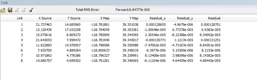
I just completed creating 8 links to rectify a 1948 aerial photo TIFF to 2013 NAIP imagery, using Arc 10.2 I'm skeptical of the Residual (RMS) error, which I use to judge how effective the links are. Please see the attached screen capture. I believe that the RMS error is in the units of the arc map session, in this case, Meters. Specifically, I'm skeptical of the 0000884777 Total RMS error. Does this look reasonable? I'm linking points on the 1948 TIFF to the same points that I've ID'd on the 2013 NAIP. Should I be linking: TIFF to Imagery? Alternatively, should I create some vector point features, overlaid on the 2013 NAIP, and then link: TIFF to point features?
Ken
Ken
Solved! Go to Solution.
16 Replies
05-12-2014
11:25 AM
- Mark as New
- Bookmark
- Subscribe
- Mute
- Subscribe to RSS Feed
- Permalink
Neil,
Your 2 comments were really helpful, as we realized Melita's calcs were for a point on the equator, but didn't know how to convert to our latitude of 39 degrees. That makes a big diff, since our error drops from 32' to 9', which is what I expect from setting 8 decent link points. Plus, we just did another geo reference, using the native projection, as you suggested, UTM, zone 11, rather the WGS84, I used in my example and got an RMS of 15' with just 5 links. In that case, our individual link points are listed in the link table in utm coordinates, meters, and we have a Total RMS error = 8 Is a conversion required, or should we interpret this error as 8 meters?
We'd like to get the group's opinion about what the lowest RMS error / minimum link points should be for old tiffs?
I'm really grateful to you and Melita for assisting our team of 4 gis people. We have scores of old tiffs to geo reference for a water rights mapping project.
Ken
05-12-2014
10:59 PM
- Mark as New
- Bookmark
- Subscribe
- Mute
- Subscribe to RSS Feed
- Permalink
Ken,
the to link coords and the reported rms error will always be in the referencing coordinate system. So the 8 will be metres.
As regards the question about accuracy, well I suppose that depends on the pixel size or original intended scale of the data.
If the referenced tiff has a pixel size of 0.5m, then 8m might seem a little off. If its 4 or 5m then you probably won't get any better.
This also depends on the accuracy / scale of the reference data as well of course.
Cheers,
Neil
05-14-2014
06:34 AM
- Mark as New
- Bookmark
- Subscribe
- Mute
- Subscribe to RSS Feed
- Permalink
Neil,
Following up on your last thread, I want to evaluate the pixel size of the imagery, we are using, and I'm not I'm interpreting the imagery's properties.
Cell Size = 1,1 Is this 1 meter by 1 meter? So, if my RMS is off 3 m that would not be considered serious error?
Pixel type= unsigned integer
pixel depth= 8 bit
By scale of the reference data, do you mean how far we are zoomed into the imagery when we do a link?
Ken
05-14-2014
10:49 PM
- Mark as New
- Bookmark
- Subscribe
- Mute
- Subscribe to RSS Feed
- Permalink
Ken,
my comment about scale was just about the data source like 1:50k aerial imagery or whatnot.
Of course, when creating links it is probably good practice to always use the same zoom level scale consistently (say 1:5000, or 2000 etc). Again this will depend on the input data source.
This cell size you have :
Is this before starting to georeference, when looking at the image properties in Catalog? If so this is just a pixel.
If it is after georeferencing, then I am a bit mystified. It seems hard to imagine how you would get the georeferencing so exact as to give you 1m instead of 1.02341999....m
my comment about scale was just about the data source like 1:50k aerial imagery or whatnot.
Of course, when creating links it is probably good practice to always use the same zoom level scale consistently (say 1:5000, or 2000 etc). Again this will depend on the input data source.
This cell size you have :
Cell Size = 1,1 Is this 1 meter by 1 meter?
Is this before starting to georeference, when looking at the image properties in Catalog? If so this is just a pixel.
If it is after georeferencing, then I am a bit mystified. It seems hard to imagine how you would get the georeferencing so exact as to give you 1m instead of 1.02341999....m
05-15-2014
06:15 AM
- Mark as New
- Bookmark
- Subscribe
- Mute
- Subscribe to RSS Feed
- Permalink
Neil,
1,1 is the pixel size according the the properties report via ArcCatalog. Based on your earlier comment, about pixel size, that must be 1 x 1 meter. Thanks for explaining the scale. I looked, unscuccessfully, for scale in the properties. We know to be zoomed way in when setting link points.
We'd really like to get your opinion on the Update Geo referencing vs Rectify options. If you prefer to use the Rectify option what adjustments to you make the Rectify menu options dialog. We've researched this and don't know how to optimize the settings. If you don't use rectify then let us know, so we can be assured we are doing the right thing by just doing update geo referencing for our scores of tiffs.
Attached is a capture of the Rectify dialog box. I couldn't figure out how to insert it directly into this window.
Our gratitude for your continued help to us,
Ken and the 3 other DWR mapping section analysts
05-15-2014
11:32 PM
- Mark as New
- Bookmark
- Subscribe
- Mute
- Subscribe to RSS Feed
- Permalink
If these tiffs are going to be used in a mosaic or by other software, it is probably wise to rectify them into the new coordinate system.
Be aware, of course, that this creates a new image file and you will need sufficient disk storage for this.
As these are aerial photos, use cubic convolution as the resampling technique.
You could also select LZW compression which will make the tiffs a bit smaller.
But that window you posted has the cell size as 0.000006, which tells me that you are still georeffing into GCS degrees units.
Why is that? A proper projected coordinate system in metres or feet or whatever is your standard will be better.
N
05-19-2014
02:48 PM
- Mark as New
- Bookmark
- Subscribe
- Mute
- Subscribe to RSS Feed
- Permalink
Neil,
Since the start of the discussion we have since changed our procedure to georeffing into utm, meters and so, now, our pixel size = 0.65 Hopefully, those are meters. I don't think we should create a new file; which is what, I'm assuming, you're refering to as creating a new file via changing the existing rectified image's projection. We simply just changed the projection of the arcmap we are using to geo reff to utm, meters.
Thank you for suggesting how we could optimize the rectify the settings, we attempted to use the esri help, with no success.
Thank you.
Ken
- « Previous
-
- 1
- 2
- Next »
- « Previous
-
- 1
- 2
- Next »