- Home
- :
- All Communities
- :
- Products
- :
- Data Management
- :
- Data Management Questions
- :
- Re: Densify... Euclidean vs Geodesic
- Subscribe to RSS Feed
- Mark Topic as New
- Mark Topic as Read
- Float this Topic for Current User
- Bookmark
- Subscribe
- Mute
- Printer Friendly Page
Densify... Euclidean vs Geodesic
- Mark as New
- Bookmark
- Subscribe
- Mute
- Subscribe to RSS Feed
- Permalink
Hi Dan Patterson - Do you know about projected versus geographic coordinate systems with the Densify tool? It says to pick an 'appropriate' spatial reference but I don't see more details. I want to make sure I densify a planar line and keep it planar. The densified lines come out ~30 meters apart depending on whether I use a PCS or GCS. I'm unclear on why, and if it's because one is planar or geodesic, or if something else is going on.
Thanks for any ideas.
- Mark as New
- Bookmark
- Subscribe
- Mute
- Subscribe to RSS Feed
- Permalink
They can't be shifted at all points hopefully, that would imply a datum shift (ie NAD27 to NAD83). I won't address that but assume that the issues are due to the densification process.
My thoughts...
A big widths, long lengths, large spacing for example (ie E-W) :
Geodetic Densify—Help | ArcGIS for Desktop
B small (less than UTM zone width maybe) :
Densify—Help | ArcGIS for Desktop
I don't have my test results here, but I tested using the following procedure:
- Locate yourself (me -75 lon, 45 lat)
- make a couple of lines that span your area of interest
- -76,44 to -74,46 a diagonal
- -75,44 to -75,46 N-S
- -76,45 to -74,45 E-W
- densify at some appropriate increment using the methods in A and B
- compare step 3
- Mark as New
- Bookmark
- Subscribe
- Mute
- Subscribe to RSS Feed
- Permalink
If you use a PCS, it should be densifying relative to the plane. A GCS should densify the line based on the geodesic line between the two points.
- Mark as New
- Bookmark
- Subscribe
- Mute
- Subscribe to RSS Feed
- Permalink
I thought so too...what got me confused was some very strange behavior where the densified GCS line (assumed to be geodesic) did not match the the same GCS line densified using Geodetic Densify. And the densified PCS line matched the Geodetic Densified lines that were both GCS and PCS. Could it be that the planar and geodesic lines over this distance (~40km) are just too similar to tell the difference?
In which case the one outlier was the GCS line that was Densified...that line would just be wrong.
- Mark as New
- Bookmark
- Subscribe
- Mute
- Subscribe to RSS Feed
- Permalink
Melita Kennedy do you agree that using 'Densify' on a GCS produces an error? Or perhaps I made an error myself?
- Mark as New
- Bookmark
- Subscribe
- Mute
- Subscribe to RSS Feed
- Permalink
Visualize
76,45 to -74,45 E-W defines two points on a parallel... aka a line of latitude.
The distance along a line of latitude (parallel) is going to be greater than the great circle distance between those two points. Calculate distance and bearing between two Latitude/Longitude points using haversine formula in Java... for an interactive example (157.3 vs 157.2 km for my examples)
So you will see deflection between the two. See Melita's answer to me.
- Mark as New
- Bookmark
- Subscribe
- Mute
- Subscribe to RSS Feed
- Permalink
Certainly - that makes sense.
I am actually wondering about the two different tools, "Densify" and "Geodetic Densify".
Melita stated that if I use the Densify tool with a layer in a GCS it will produce a geodesic line. It seems like, then, if I also used the same line in the Geodetic Densify tool, it should match result of the Densify tool (at least one output, since the Geodetic Densify has options).
However, when I have a layer in a GCS these two tools produce different results -- none of the Geodetic Densify outputs match Densify. What underlying assumption is in the Densify tool for a feature in GCS?
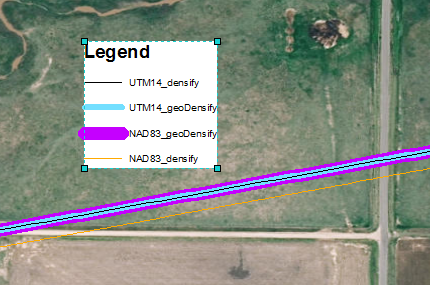
Hopefully I am making sense. Here is another graphic to try to explain my question.
- Mark as New
- Bookmark
- Subscribe
- Mute
- Subscribe to RSS Feed
- Permalink
Sarah did you ever get to the bottom of this?
- Mark as New
- Bookmark
- Subscribe
- Mute
- Subscribe to RSS Feed
- Permalink
I did not.
- Mark as New
- Bookmark
- Subscribe
- Mute
- Subscribe to RSS Feed
- Permalink
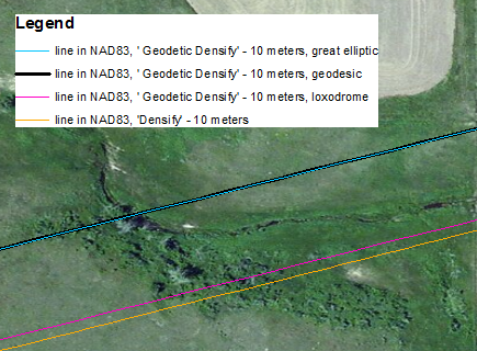
I think I had it wrong, and confused Densify with Buffer. Because the Densify with NAD83 is closer to the loxodrome line, I think it's doing a 2D Cartesian densification. If you don't know, a loxodrome is a straight line in Mercator, and may or may not be straight in a different coordinate system.
I'm sorry for the confusion.