Turn on suggestions
Auto-suggest helps you quickly narrow down your search results by suggesting possible matches as you type.
Cancel
- Home
- :
- All Communities
- :
- Products
- :
- Data Management
- :
- Data Management Questions
- :
- Define Projection - Raster
Options
- Subscribe to RSS Feed
- Mark Topic as New
- Mark Topic as Read
- Float this Topic for Current User
- Bookmark
- Subscribe
- Mute
- Printer Friendly Page
Define Projection - Raster
Subscribe
2479
2
11-03-2009 08:01 AM
11-03-2009
08:01 AM
- Mark as New
- Bookmark
- Subscribe
- Mute
- Subscribe to RSS Feed
- Permalink
I used ArcToolbox (from customize docked on side) to define the projection of an ascii file imported to a grid. Normally this takes a minute or two. It has taken 57 minutes. The raster is in the default file geodatabase and is about 400 meg in size. It should not take this long to define a projection. I am not projecting the grid.
2 Replies
11-04-2009
09:52 AM
- Mark as New
- Bookmark
- Subscribe
- Mute
- Subscribe to RSS Feed
- Permalink
Can you please fill out the Technical Support request form to log a bug and explain the details of the problem.
In the meantime, can you define the projection of the raster using ArcCatalog and right-clicking into the properties? This should be a workaround so you can move forward and continue testing 9.4 beta.
Thanks for your feedback.
In the meantime, can you define the projection of the raster using ArcCatalog and right-clicking into the properties? This should be a workaround so you can move forward and continue testing 9.4 beta.
Thanks for your feedback.
11-04-2009
11:13 AM
- Mark as New
- Bookmark
- Subscribe
- Mute
- Subscribe to RSS Feed
- Permalink
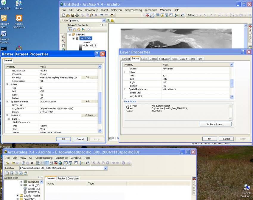
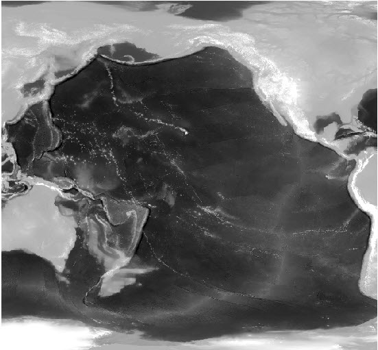
OK, I figured out one of the problems. It turns out I had been given a grid that went from +120 (west coast US) to +292 (western Australia). I was told it was wgs 84. Anyway, I managed to use the shift command under projections & transformations/raster to get the data shifted -360°. I then tried to define the projection again. It work failry fast this time, however the properties did not show the projection. I did this twice with no projection showing up in the properties window. If I look at it in arcmap/arccatalog there is no projection defined. However, if I open up traditional arccatalog, the projection is defined. I attached screen grabs for your information. If I look at the grid directory I see the prj.adf which is defined correctly.
Next I tried changing the projection of the data frame, and indeed the grid cannot project on the fly. Then I tried adding the grid from traditional ArcCatalog to the data frame. It gave me a warning about the data lacking a projection. When I removed the layer and added it again, no error appeared, however it still could not project on the fly. Do you think this is happening because my data goes 0 to -360 instead of +-180? My data also crossed the 180° line. It is about 500 MB in zip format.
Next I went to 9.3.1 arcmap. It sees the projection in the properties window, but cannot project on the fly. If I set the data frame to wgs84, my vector data lies over the grid correctly, except for that which crosses 180° which is on the other side of the screen.
So, my problem is figuring out how to get the data in a projection arcmap will recognize. Your problem may be the properties display difference between arccatalog stand-alone and arcmap as the projection information is present in the grid.