- Home
- :
- All Communities
- :
- Products
- :
- Data Management
- :
- Data Management Questions
- :
- Re: Custom polygon shapes for drawing ?
- Subscribe to RSS Feed
- Mark Topic as New
- Mark Topic as Read
- Float this Topic for Current User
- Bookmark
- Subscribe
- Mute
- Printer Friendly Page
Custom polygon shapes for drawing ?
- Mark as New
- Bookmark
- Subscribe
- Mute
- Subscribe to RSS Feed
- Permalink
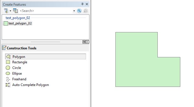
So I would like to create additional options for custom shapes when editing a polygon feature. Something to the same functionality of the 'Construction Tools' as pictured below, but with a greater variety of shapes (like a triangle, pentagon, irregular shape as below, etc).
Wondering what the best method would be to go about this? I'm assuming it's not possible to add custom shapes directly into the already existing Construction Tools panel (tho I'm not technically versed enough to know).. but in that case would writing an Add-In be the best way? Is it possible?
..I probably won't be doing this by myself unless it requires minimal coding experience, but I'd really appreciate if someone can point me to the correct basic approach!
- Mark as New
- Bookmark
- Subscribe
- Mute
- Subscribe to RSS Feed
- Permalink
Hello Kira,
It is possible to create custom shapes. It does, however, require python code to perform it. I can pass some code along to you. It basically works, in a manner, where the user drops a point and then draws a polygon. I used it to create many polygons based on zoning. The polygons were basic shapes based on length and height. If you had several custom shapes, then code would have to account for the dimensions.Also, you would have to start an edit session to orient the shapefiles.
Let me know if you want the code
James
- Mark as New
- Bookmark
- Subscribe
- Mute
- Subscribe to RSS Feed
- Permalink
Yes, I'd love to see that code! 
That'd be brilliant. Thanks for the response~
- Mark as New
- Bookmark
- Subscribe
- Mute
- Subscribe to RSS Feed
- Permalink
I would love to see the code as well if that would be possible. This could same me quite a bit of time. Thanks!
- Mark as New
- Bookmark
- Subscribe
- Mute
- Subscribe to RSS Feed
- Permalink
import arcpy, os
arcpy.env.workspace = "U:\Tax\Special Projects\JEFitzgerald\CUVA\2014\CUVA_PYTHON_06252014_Final\CUVA.mdb"
pointList=[]
#Finds the field named File and deletes it
try:
    with arcpy.da.UpdateCursor("GC_R20_Polygon",("File"),'[File] =\'Done\'') as cursor:
        cntr = 1
        for row in cursor:
            cursor.deleteRow()
            print "Record number "+ str(cntr) + " deleted"
            cntr = cntr + 1
except Exception as e:
    print e.message

            #****  CODE for R20    ****#
try:
    with arcpy.da.SearchCursor ("GC_R20", ["SHAPE@XY"]) as cursor:
        for row in cursor:
            xy = row[0]
            pointList.append(xy)


    with arcpy.da.InsertCursor ("GC_R20_Polygon", ["SHAPE@"]) as U:
        for pnt in pointList:
            lowX = pnt[0]
            lowY = pnt[1]
        #   find the upper right
            highX = lowX + 162.2539
            highY = lowY + 123.2639
            array = arcpy.Array([arcpy.Point(lowX, lowY),
                             arcpy.Point(lowX, highY),
                             arcpy.Point(highX, highY),
                             arcpy.Point(highX, lowY),
                             arcpy.Point(lowX, lowY)])
            polygon = arcpy.Polygon(array)
            U.insertRow([polygon])

    #Populates a field with DONE so the delete cursor will find and delete.
    #This will enable a clean attribute table so dublicates will be eliminated.
    arcpy.CalculateField_management("GC_R20_Polygon","File", "\"Done\"", "PYTHON", "")
    print "Process for new polygons is complete"
    print "James E. Fitzgerald, GISP, GIS Specialist"
except:
    print
- Mark as New
- Bookmark
- Subscribe
- Mute
- Subscribe to RSS Feed
- Permalink
Hello,
With this code you have to create your shapefiles. I am new to Python Scripting so there may be excess to delete. Thanks,
James
- Mark as New
- Bookmark
- Subscribe
- Mute
- Subscribe to RSS Feed
- Permalink
James Fitzgerald, Thanks so much for posting this. I'm super new to Python, but I think I understand what the code is doing, but could you explain a little more how to implement it in ArcGIS? You mentioned to have an Edit session open.. Perhaps which parameters need to be changed or the defined 'workspace'? Not quite sure how that works. If I run this in Arc atm, in an open Edit session, I get "cannot open 'GC_R20_Polygon'".
- Mark as New
- Bookmark
- Subscribe
- Mute
- Subscribe to RSS Feed
- Permalink
You have to create a point.shp (GC_R20). GC_R20.shp is what I used give me the starting point in terms of XY. Also, you have to have a polygon created too. I named it GC_R20_Polygon. I edited the original code to exclude unnecessary code.
import arcpy, os
arcpy.env.workspace = "U:\Tax\Special Projects\JEFitzgerald\CUVA\2014\CUVA_PYTHON_06252014_Final\CUVA.mdb"
pointList=[]

    try:
            with arcpy. ["SHAPE@XY"]) as cursor:
        for row in cursor:
            xy = row[0]
            pointList.append(XY)

    with arcpy.0_Polygon", ["SHAPE@"]) as U:
        for pnt in pointList:
            lowX = pnt[0]
            lowY = pnt[1]
        #   find the upper right
            highX = lowX + 162.2539
            highY = lowY + 123.2639
            array = arcpy.Array([arcpy.Point
                             arcpy.Point(lowX, highY),
                             arcpy.Point(highX, highY),
                             arcpy.Point(highX, lowY),
                             arcpy.Point(lowX, lowY)])
            polygon = arcpy.Polygon(array)
            U.insertRow([polygon])

    #Populates a field with DONE so the delete cursor will find and delete.
    #This will enable a clean attribute table so dublicates will be eliminated.
    arcpy.CalculateField_management("GC_R20_Polygon","File", "\"Done\"", "PYTHON", "")
    print "Process for new polygons is complete"
except:
    print
- Mark as New
- Bookmark
- Subscribe
- Mute
- Subscribe to RSS Feed
- Permalink
I think you accidentally removed parts that are necessary for the code to work? i.e Line 6 and Line 11.
On a side note, this code will work for 10.1 and up. the Data Access module was introduced at 10.1. I am only on 10  and can't test it. But thanks anyways, I'll keep it in my back pocket.with
- Mark as New
- Bookmark
- Subscribe
- Mute
- Subscribe to RSS Feed
- Permalink
That gave me some syntax errors, but I edited the code a little (below) and created my own shape named GC_R20, with a polygon also named GC_R20.. I run it through the Python window in Arc and receive no errors, but nothing seems to happen either. Should this add a polygon to a template somewhere, or should it work if I start drawing in the Edit session?
(for some reason it's not letting me apply the code style atm..)
import arcpy, os
arcpy.env.workspace = "D:/TESTING"
pointList=[]
try:
with arcpy.da.SearchCursor ("GC_R20", ["SHAPE@XY"]) as cursor:
for row in cursor:
xy = row[0]
pointList.append(XY)
with arcpy.da.InsertCursor ("GC_R20", ["SHAPE@"]) as U:
for pnt in pointList:
lowX = pnt[0]
lowY = pnt[1]
# find the upper right
highX = lowX + 162.2539
highY = lowY + 123.2639
array = arcpy.Array([arcpy.Point(lowX, lowY),
arcpy.Point(lowX, highY),
arcpy.Point(highX, highY),
arcpy.Point(highX, lowY),
arcpy.Point(lowX, lowY)])
polygon = arcpy.Polygon(array)
U.insertRow([polygon])
#Populates a field with DONE so the delete cursor will find and delete.
#This will enable a clean attribute table so dublicates will be eliminated.
arcpy.CalculateField_management("GC_R20","File", "\"Done\"", "PYTHON", "")
print "Process for new polygons is complete"
except: