Turn on suggestions
Auto-suggest helps you quickly narrow down your search results by suggesting possible matches as you type.
Cancel
- Home
- :
- All Communities
- :
- Products
- :
- Data Management
- :
- Data Management Questions
- :
- Re: Creating mosaic dataset for basemap
Options
- Subscribe to RSS Feed
- Mark Topic as New
- Mark Topic as Read
- Float this Topic for Current User
- Bookmark
- Subscribe
- Mute
- Printer Friendly Page
Creating mosaic dataset for basemap
Subscribe
3581
7
05-24-2012 08:37 AM
05-24-2012
08:37 AM
- Mark as New
- Bookmark
- Subscribe
- Mute
- Subscribe to RSS Feed
- Permalink
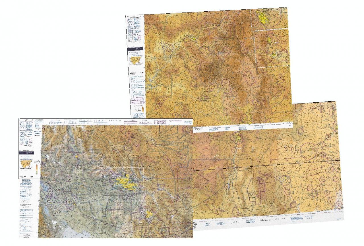
Hello, I have about 55 geotifs covering the US, and would like to use them to create a basemap to publish in ArcGIS server (see this link for a previous post. I'm curious if anyone has any suggestions or resources to lead me through the best way to start this process on the ArcMap side. For instance, should I create a mosaic dataset or a raster dataset? Also, the rasters have some extraneous information off to the side that I would like to exclude from the basemap (see attached image)[ATTACH=CONFIG]14608[/ATTACH]. Is this even possible to do using ArcMap? I am experienced with working with vector data and ArcGIS Server, but don't know how to get started on this process or if this is even the wrong way to go about it.
Thanks, Jay
Thanks, Jay
7 Replies
05-24-2012
09:11 AM
- Mark as New
- Bookmark
- Subscribe
- Mute
- Subscribe to RSS Feed
- Permalink
Jay,
The first question is do you have licensing for the ArcGIS Server Image Extension? Without it, you can only serve raster datasets, not mosaic datasets. Removing the collars off the images shouldn't be that hard if you adjust the footprints of the mosaic dataset.
Eric
The first question is do you have licensing for the ArcGIS Server Image Extension? Without it, you can only serve raster datasets, not mosaic datasets. Removing the collars off the images shouldn't be that hard if you adjust the footprints of the mosaic dataset.
Eric
05-24-2012
09:50 AM
- Mark as New
- Bookmark
- Subscribe
- Mute
- Subscribe to RSS Feed
- Permalink
So I don't believe I have the ArcGIS Server Image extension, which means I am relegated to only working with raster datasets....
Are my goals still possible with raster datasets - mosaicing some 55 geotifs into a raster dataset (removing the collars first)? Would looking into the Server Image Extension have a strong benefit for this task, or is working with raster datasets enough?
Regardless, what would be the easiest / best way to adjust the footprints? Manually drawing, or somehow clipping to any primarily white-colored border (although not all white)? Will the build footprints tool work, and would I have to perform it on each individual raster? Sorry for all the questions - I looked around online but couldn't find any tutorials related to these types of tasks.
Thanks, Jay
05-24-2012
10:55 AM
- Mark as New
- Bookmark
- Subscribe
- Mute
- Subscribe to RSS Feed
- Permalink
Jay,
To fix the collars create a mosaic dataset and use the "Build Footprints Tool".
http://help.arcgis.com/en/arcgisdesktop/10.0/help/index.html#//00170000008n000000
This tool will remove 99% of the collar around your images.
If it does not, you could always manually edit the mosaic dataset footprints to remove the collar.
To cache your mosaic dataset, you DO NEED THE IMAGE EXTENSION.
http://help.arcgis.com/en/arcgisdesktop/10.0/help/index.html#//009t000000p0000000
All you need to do is take your mosaic dataset and drop it into a map document and then publish that document as a map service.
Once published you can then generate the tiled cache.
Hope this helps,
Nelson
05-24-2012
12:10 PM
- Mark as New
- Bookmark
- Subscribe
- Mute
- Subscribe to RSS Feed
- Permalink
If I am not mistaken, you do need to have the Image Extension for ArcGIS Server to add a mosaic dataset to an MXD and publish it successfully to ArcGIS Server.
http://forums.arcgis.com/threads/51007-caching-tiles-in-mosaic-dataset
Please see the post from Melanie.
http://forums.arcgis.com/threads/51007-caching-tiles-in-mosaic-dataset
Please see the post from Melanie.
However, when using a mosaic dataset, even in a map document the ArcGIS Server Image Extension is required.
05-25-2012
06:07 AM
- Mark as New
- Bookmark
- Subscribe
- Mute
- Subscribe to RSS Feed
- Permalink
If it does not, you could always manually edit the mosaic dataset footprints to remove the collar.
I was wondering how to manually edit the footprints (the radiometric method worked pretty well, but there are sometimes a couple edges I'd like to smooth over).
I tried starting an edit session, but couldn't select the footprints polygon to edit vertices....
Thanks, Jay
05-25-2012
06:12 AM
- Mark as New
- Bookmark
- Subscribe
- Mute
- Subscribe to RSS Feed
- Permalink
Jay,
You should be able to use the editor to manually edit the footprints.
I couple of things you should check are: 1) make sure there are no locks on your MD (mosaic dataset) ie. don't have it open in catalog and arcmap at the same time or 2) if you're currently serving the MD, stop that service.
I usually just bring the mosaic dataset into a fresh arcmap session, expand it and right click the footprint layer.
I make this layer the only selectable layer and then start an edit session.
Let me know if this works,
Cheers,
05-25-2012
07:21 AM
- Mark as New
- Bookmark
- Subscribe
- Mute
- Subscribe to RSS Feed
- Permalink
Jay,
You have quite a bit of overlap in the images. Have you tried increasing the Shrink parameter when building footprints? You should be able to shrink somewhat excessivley because of the amount of overlap. It will be better than manually editing, which you can do using the tips above.
The mosaic dataset is the approach to take for resolving the image collars, but to serve it you must have the Image Extension regardless of whether you make an image service from the MD or if you make a map service with the MD in it. Without the extension you are going to have to create a flat file on disk of the whole thing (a raster dataset), then publish that. Basically, you run Copy Raster or Export Data from the UI, and input the mosaic dataset.
Regards,
Eric