- Home
- :
- All Communities
- :
- Products
- :
- Data Management
- :
- Data Management Questions
- :
- Creating a Route on a Stream System
- Subscribe to RSS Feed
- Mark Topic as New
- Mark Topic as Read
- Float this Topic for Current User
- Bookmark
- Subscribe
- Mute
- Printer Friendly Page
Creating a Route on a Stream System
- Mark as New
- Bookmark
- Subscribe
- Mute
- Subscribe to RSS Feed
- Permalink
I have a stream polyline feature class that I would like to turn into a route for linear referencing. I added a field called Miles for which to base the M value is to be based. Using the Create Routes tool (in ArcGIS 10.5.1 or ArcGIS Pro 2.1.2) I'm running into a snag.
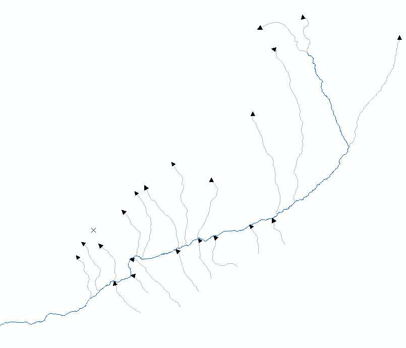
When I set the Coordinate Priority option to Upper_Right, my river miles are not correct for half the streams. Please refer to the image below. The main stream is highlighted in blue, and I have symbolized each of the tributaries with the arrow heads at the end of the line. The main stream and the tributaries that flow in from the south have their river miles correct: they increase from the source downhill to the confluence. However, the tributaries that flow in from the north are all bass-ackwards. Flipping a route segment in an edit session does not seem to correct the problem.
Bottom line: how do you create a Route of existing features and have the measurement value follow the direction of the polyline from-to?
- Mark as New
- Bookmark
- Subscribe
- Mute
- Subscribe to RSS Feed
- Permalink
Here is what I did to correct the issue, although I'm all ears if there is a better way:
On each of my stream segments, I had calculated a 'Miles' field. I then added two more fields: 'Start' which I calculated to 0 (zero) and End which I calculated to the 'Miles' field value. Instead of using Coordinate Priority, I used the From-Measure-Field and To-Measure-Field options with Start and End respectively...
- Mark as New
- Bookmark
- Subscribe
- Mute
- Subscribe to RSS Feed
- Permalink
Joe I do not believe there are any better ways, only different flavors.
In my shop, not dealing with streams but road I have similar situations and some difficult (political) when dealing with LRS... My ramps and connecting roads are like your tributaries and the mainline analogous to the main river...
I have to use two options.... For the Main line since it is political and funding is derived from mileage, I use calibration points to create dynamic segmentation... for the ramps like your tributaries I simply use the length along option starting at 0 and make sure all the road segments are drawn in the proper direction (orientation)... The only times I had issues with coordinate priority is if I had the line segments that I building the LRS from accidentally drawn in the wrong directions or had small gaps in between.