- Home
- :
- All Communities
- :
- Products
- :
- Data Management
- :
- Data Management Questions
- :
- Re: Converting Zipcodes to Polygons
- Subscribe to RSS Feed
- Mark Topic as New
- Mark Topic as Read
- Float this Topic for Current User
- Bookmark
- Subscribe
- Mute
- Printer Friendly Page
Converting Zipcodes to Polygons
- Mark as New
- Bookmark
- Subscribe
- Mute
- Subscribe to RSS Feed
- Permalink
Greetings,
I have two files I am trying to join so that I can look at some program data by zipcode. I have found a csv file of zipcode with lat/long and I have a data file with zipcodes only.
I uploaded my zipcode w/ lat/long file to Arc Online with the intention of joining my data file to it so that I could create visualizations. Unfortunately, the zipcode lat/long file renders as point data only and does not create polygons.
I would really appreciate some assistance in figuring out what I am doing wrong. I also have Arc Desktop on my computer. I had intended to upload my zipcode w/ lat/long files to Arc online so that I could convert to a .shp file for use on my desktop.
Any assistance would be supper helpful. I have attached the zipcode w/ lat/long files.
Please help!
- Mark as New
- Bookmark
- Subscribe
- Mute
- Subscribe to RSS Feed
- Permalink
search using .... zip code shapefile u.s.
https://www.arcgis.com/home/item.html?id=8d2012a2016e484dafaac0451f9aea24
plus more
Then you should be able to join attributes to it if it is in the correct form
- Mark as New
- Bookmark
- Subscribe
- Mute
- Subscribe to RSS Feed
- Permalink
Thanks for your reply Dan. I downloaded and opened the file in Arc Desktop then added my data file and joined the tables. My initial goal is to create a chloropleth map. Looking at the new table all looks good, but when I go to edit the layer it gives me an error. I feel like I am missing something so simple. It has been some time since I worked with the Dekstop version.

- Mark as New
- Bookmark
- Subscribe
- Mute
- Subscribe to RSS Feed
- Permalink
convert your csv file to a shapefile or a featureclass... simply right-click on the layer, then data, export data and specify your type and filename at the bottom
- Mark as New
- Bookmark
- Subscribe
- Mute
- Subscribe to RSS Feed
- Permalink
It looks like you are attempting to edit the csv table. Export it to a geodatabase table from the attribute table menu:
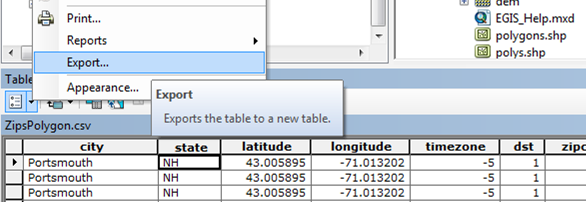
Then it will have assigned OIDs and you should be able to edit it.
- Mark as New
- Bookmark
- Subscribe
- Mute
- Subscribe to RSS Feed
- Permalink
I'm a little confused as to how you would attempt to create polygon's from that CSV you uploaded. Some of the entries only have a single LAT\LONG entry so you would only have a single point for that entry. Each zip code entry needs to have 3 or more LAT\LONG entries to make a polygon.
- Mark as New
- Bookmark
- Subscribe
- Mute
- Subscribe to RSS Feed
- Permalink
it appears from the records that the csv file contains multiple points with the same coordinates...all you need is one point in a point file to join it to a polygon file using a common key field...which I presume is the postal code.. and hoping that they are in the exact same format and level of detail
- Mark as New
- Bookmark
- Subscribe
- Mute
- Subscribe to RSS Feed
- Permalink
Oh okay I misunderstood what Hilary was looking to do with the CSV file she uploaded. I thought she was attempting to create polygons from the lat\long points in the csv. Maybe she is attempting to generate a point feature class from the CSV and use a spatial join with one-to-many join operation on an existing polygon feature?
- Mark as New
- Bookmark
- Subscribe
- Mute
- Subscribe to RSS Feed
- Permalink
Is suspect it may have been a polygon file in csv format... sort of useless... hence the link amongst many, that allows you to download polygon geometry. That is why I wondered about the duplicate records, I suspect that each polygon point has the same attributes for each point.