Turn on suggestions
Auto-suggest helps you quickly narrow down your search results by suggesting possible matches as you type.
Cancel
- Home
- :
- All Communities
- :
- Products
- :
- Data Management
- :
- Data Management Questions
- :
- Continuous identity for connected line segments
Options
- Subscribe to RSS Feed
- Mark Topic as New
- Mark Topic as Read
- Float this Topic for Current User
- Bookmark
- Subscribe
- Mute
- Printer Friendly Page
Continuous identity for connected line segments
Subscribe
10-23-2012
07:32 AM
- Mark as New
- Bookmark
- Subscribe
- Mute
- Subscribe to RSS Feed
- Permalink
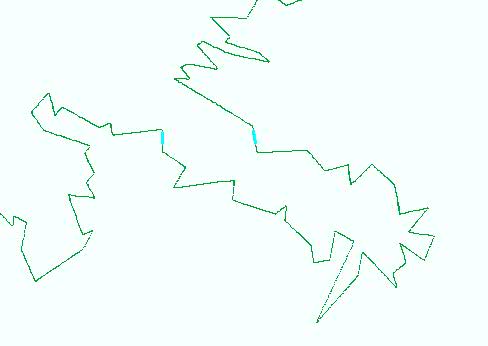
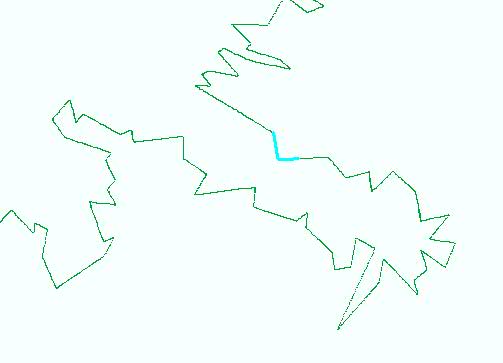
I have converted a raster to polyline feature. I want identity of the line segments should be continuous as their connection but in my case it is different. As we can see in the figure 1. The selected segments are ids 156 and 157. Is there any way to rearrange the id or assign new field, so id 157 should be connected with 156 as figure 2?
Thanks in advance.
[ATTACH=CONFIG]18646[/ATTACH](figure 1) [ATTACH=CONFIG]18647[/ATTACH](figure 2)
Thanks in advance.
[ATTACH=CONFIG]18646[/ATTACH](figure 1) [ATTACH=CONFIG]18647[/ATTACH](figure 2)
Solved! Go to Solution.
1 Solution
Accepted Solutions
by
Anonymous User
Not applicable
10-25-2012
07:16 AM
- Mark as New
- Bookmark
- Subscribe
- Mute
- Subscribe to RSS Feed
- Permalink
Original User: ddahal
Dan Thanks.
Your solution seems workable but I already used different approach. I created another raster 'B' with id values and combined with my raster 'A' and converted to the line. Later I joined the tables in the line from Raster 'B' so I was able to have the result as I needed.
Dan Thanks.
Your solution seems workable but I already used different approach. I created another raster 'B' with id values and combined with my raster 'A' and converted to the line. Later I joined the tables in the line from Raster 'B' so I was able to have the result as I needed.
2 Replies
10-24-2012
08:03 AM
- Mark as New
- Bookmark
- Subscribe
- Mute
- Subscribe to RSS Feed
- Permalink
Try this (if you have an arcinfo license):
1. Run Feature Vertices To Points tool (Data Management toolbox - Features toolset) uisng the BOTH_ENDS option to get endpoints of all lines.
2. Run Unsplit Lines tool (in the same toolset) to merge lines at pseudo nodes (where only two lines connect).
3. Run Split Line At Points (in the same toolset) to break the merged lines at the endpoints; the resulting lines should be the same as the original lines, hopefully in continuous order.
4. Run Spatial Join (Analysis toolbox - Overlay toolset) with SHARE_A_LINE_SEGMENT_WITH option to join the split lines with the original lines to get the attributes through Field Map.
Does that work?
by
Anonymous User
Not applicable
10-25-2012
07:16 AM
- Mark as New
- Bookmark
- Subscribe
- Mute
- Subscribe to RSS Feed
- Permalink
Original User: ddahal
Dan Thanks.
Your solution seems workable but I already used different approach. I created another raster 'B' with id values and combined with my raster 'A' and converted to the line. Later I joined the tables in the line from Raster 'B' so I was able to have the result as I needed.
Dan Thanks.
Your solution seems workable but I already used different approach. I created another raster 'B' with id values and combined with my raster 'A' and converted to the line. Later I joined the tables in the line from Raster 'B' so I was able to have the result as I needed.