- Home
- :
- All Communities
- :
- Products
- :
- Data Management
- :
- Data Management Questions
- :
- Co-ordinate trouble in ArcMap
- Subscribe to RSS Feed
- Mark Topic as New
- Mark Topic as Read
- Float this Topic for Current User
- Bookmark
- Subscribe
- Mute
- Printer Friendly Page
- Mark as New
- Bookmark
- Subscribe
- Mute
- Subscribe to RSS Feed
- Permalink
I have added a series of Co-ordinates into ArcMap from an excel workbook and the import fine without any trouble, however when added a basemap check the were in the correct place, they are appearing in the middle of the sea off the coast of Newquay when they should be the other end of the country in Orkney off the coast of Scotland. The co-ordinates were added as british national grid so I projected them to WGS to see if the would be the problem but they just move about an inch to the left so no luck.. however when you input the co-ordinates into google earth they are appearing in the right place?
Any help would be much appreciated!
Solved! Go to Solution.
Accepted Solutions
- Mark as New
- Bookmark
- Subscribe
- Mute
- Subscribe to RSS Feed
- Permalink
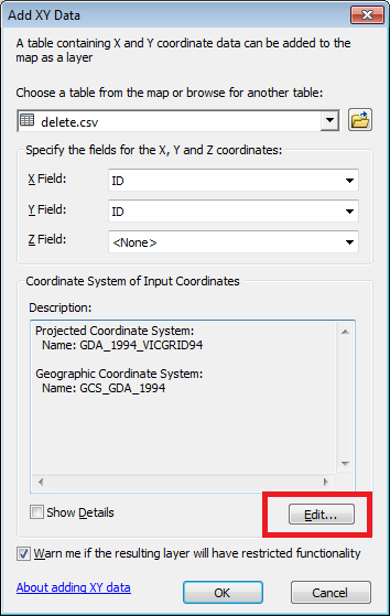
Make sure you are specifying the correct coordiate system when adding your coordinates to your map, if XY data is the first layer on the map then the layer will be added with undefined coordinate system.
If your base map and your coordinates are in different coordinate system, if you don't explicitly specify the coordinate system when adding map, arcmap will not be able to correctly project on fly.

- Mark as New
- Bookmark
- Subscribe
- Mute
- Subscribe to RSS Feed
- Permalink
If Riyas Deen 's answer doesn't help, please post an example coordinate pair from your Excel worksheet. My guess is that the coordinates aren't in BNG, but are latitude-longitude.
Melita
- Mark as New
- Bookmark
- Subscribe
- Mute
- Subscribe to RSS Feed
- Permalink
This might be useful for future iterations of this problem: https://community.esri.com/groups/coordinate-reference-systems/blog/2018/12/12/checklist-adding-coor...