- Home
- :
- All Communities
- :
- Products
- :
- Data Management
- :
- Data Management Questions
- :
- Re: Clipping Mosaic Dataset
- Subscribe to RSS Feed
- Mark Topic as New
- Mark Topic as Read
- Float this Topic for Current User
- Bookmark
- Subscribe
- Mute
- Printer Friendly Page
- Mark as New
- Bookmark
- Subscribe
- Mute
- Subscribe to RSS Feed
- Permalink
Hello,
I've created a mosaic data set that contains population information at five time points for the African continent (2000, 2005, 2010, 2015, 2020). There is one raster for each time point (ie, 2000 population, 2005 population, etc.). So there are a total of five rasters in the mosaic data set. Because these rasters are large, my goal is to clip the mosaic data set by an area of interest (AOI) defined by a polygon and produce a mosaic data set that includes the rasters for the five time points but clipped by the AOI. I would then do my analysis using this AOI mosaic data set. However, when I use the Clip (Data Management) tool, I'm returned only a single raster data set with two values: 0 and a large number that depends on the area that I've clipped. Below is how I filled out the Clip tool:
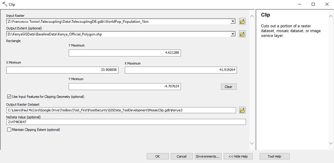
The Input Raster field is filled out with the path to the mosaic data set and the the Output Extent is a path leading to a shapefile for the area of interest (in this case, Kenya). But, as I mentioned above, the output is a single raster data set of Kenya with only two values, 0 and 134582.
I'm curious if part of the problem I'm having is due to the fact that all of my rasters within the mosaic data set overlap completely? In other words, the raster for African population in the year 2000 overlaps perfectly with the raster for African population in the year 2005, and so on. Is there a way to run the Clip tool - or any other tool for that matter - on a time series mosaic data set, like the one I have here, and have it return a time series mosaic data set that has been clipped by the AOI?
Thank you for your help.
Paul
Solved! Go to Solution.
Accepted Solutions
- Mark as New
- Bookmark
- Subscribe
- Mute
- Subscribe to RSS Feed
- Permalink
Hi Paul
You can create a ref mosaic and edit the boundary to your AOI.
You can also copy & paste to a new mosaic (The mosaic is only the index, it does not contain the rasters) and, again, edit your boundaries.
It will create a mosaic without any data (from the client point of view) outside the boundary.
Have fun
Mody
- Mark as New
- Bookmark
- Subscribe
- Mute
- Subscribe to RSS Feed
- Permalink
Thanks Mody! I think I'm now on the right track, but I'm getting a strange output when I edit the boundaries. I took your advice and copy and pasted my mosaic data set to a new mosaic and then edited the boundary of the new mosaic by right clicking on the mosaic data set in the Catalog panel, then choosing Modify, then choosing Import Footprints or Boundary.
I filled out the tool as shown below, making sure that the Target Feature Class was set to Boundary:

However, my output was the following:

It might be hard to see, but there's a Boundary around Kenya as I was hoping to get (in purple just right of center), but as you can see there's nothing to view now. When I select the value of pixels both within and outside of the Boundary, I get a pixel value of -1. I imagine there's a simple explanation or a simple step that I'm missing here.
Thanks again,
Paul
- Mark as New
- Bookmark
- Subscribe
- Mute
- Subscribe to RSS Feed
- Permalink
Apologies, as you suggested, I've now run the Create Referenced Mosaic Dataset tool using the Kenya polygon to set the Extent from Dataset, and it works perfectly.
Thanks for your help!
Paul