- Home
- :
- All Communities
- :
- Products
- :
- Data Management
- :
- Data Management Questions
- :
- Can you geocode data by US Counties?
- Subscribe to RSS Feed
- Mark Topic as New
- Mark Topic as Read
- Float this Topic for Current User
- Bookmark
- Subscribe
- Mute
- Printer Friendly Page
Can you geocode data by US Counties?
- Mark as New
- Bookmark
- Subscribe
- Mute
- Subscribe to RSS Feed
- Permalink
Is there a way to get US Counties as an option for geocoding data in ArcGIS Online? State level is too course resolution and city is too fine.... so county would be perfect....
- Mark as New
- Bookmark
- Subscribe
- Mute
- Subscribe to RSS Feed
- Permalink
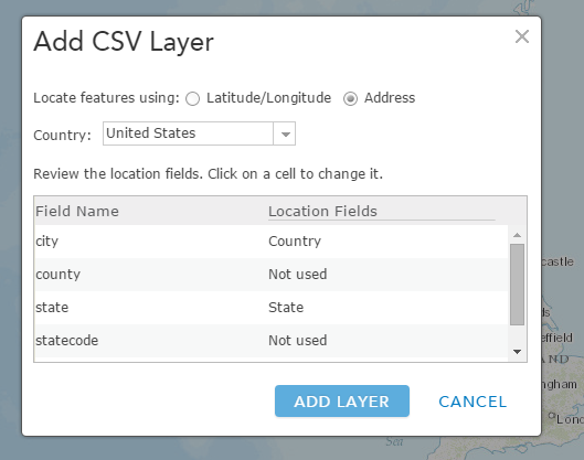
Yes you should be able to. Just don't put any address information finer than county level.
Example: Douglas County, KS.
Do note that it will most likely put every point that has the same county in the center of the county and on top of each other.
-Steven
- Mark as New
- Bookmark
- Subscribe
- Mute
- Subscribe to RSS Feed
- Permalink
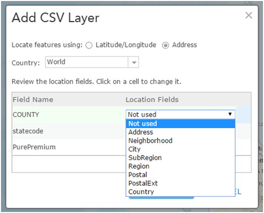
Than you for your reply Steven but I am still not getting the option for "County". I have stripped out the City info and now the data I am trying to upload has 3 columns (County, State, Value). When I select United States as the country it automatically selects "World" instead and I get the following options:
Many thanks in advance
- Mark as New
- Bookmark
- Subscribe
- Mute
- Subscribe to RSS Feed
- Permalink
Because this is a world geocoding service, county is probably referred to as Region or SubRegion in the geocoder. I can't find the help document for the service. If I find it, I will post it.
-Steven
- Mark as New
- Bookmark
- Subscribe
- Mute
- Subscribe to RSS Feed
- Permalink
Here the document that discusses the fields. It looks like SubRegion is what you want for County.
Service output—ArcGIS REST API: World Geocoding Service | ArcGIS for Developers
-Steven