Turn on suggestions
Auto-suggest helps you quickly narrow down your search results by suggesting possible matches as you type.
Cancel
- Home
- :
- All Communities
- :
- Products
- :
- Data Management
- :
- Data Management Questions
- :
- Can't see pixels when zooming in Mosaic Dataset - ...
Options
- Subscribe to RSS Feed
- Mark Topic as New
- Mark Topic as Read
- Float this Topic for Current User
- Bookmark
- Subscribe
- Mute
- Printer Friendly Page
Can't see pixels when zooming in Mosaic Dataset - blurry effect
Subscribe
1441
4
12-12-2011 05:41 AM
12-12-2011
05:41 AM
- Mark as New
- Bookmark
- Subscribe
- Mute
- Subscribe to RSS Feed
- Permalink
- Report Inappropriate Content
Why can't I see clear and distinct pixels from my mosaic dataset when I zoom in?
See attached image.
See attached image.
4 Replies
12-12-2011
06:44 AM
- Mark as New
- Bookmark
- Subscribe
- Mute
- Subscribe to RSS Feed
- Permalink
- Report Inappropriate Content
Are the visible pixels from the source rasters or the mosaic dataset overviews? Right click on the Image > Zoom to Raster resolution to see if the pixels display the same. If they display differently, then there is probably an issue with the overviews. Also, could you please provide a screen shot showing the original imagery for this same view?
12-12-2011
07:25 AM
- Mark as New
- Bookmark
- Subscribe
- Mute
- Subscribe to RSS Feed
- Permalink
- Report Inappropriate Content
Thanks Timothy for your reply.
I've attached two new screen shots comparing the source raster (Landsat) with the mosaic dataset
Are the visible pixels from the source rasters or the mosaic dataset overviews?
Right click on the Image > Zoom to Raster resolution to see if the pixels display the same. If they display differently, then there is probably an issue with the overviews.
The first attachement is a screen shot of the Zoom to Raster. Left side is the source raster. Right side is the mosaic dataset
Also, could you please provide a screen shot showing the original imagery for this same view?
I've attached screen shot, but not same area as original post (second attachment). When zooming in, on the original raster we see the distinct pixels of the Landsat imagery (left), but blurry effect on the mosaic dataset view (right)
12-13-2011
05:11 AM
- Mark as New
- Bookmark
- Subscribe
- Mute
- Subscribe to RSS Feed
- Permalink
- Report Inappropriate Content
12-13-2011
06:23 AM
- Mark as New
- Bookmark
- Subscribe
- Mute
- Subscribe to RSS Feed
- Permalink
- Report Inappropriate Content
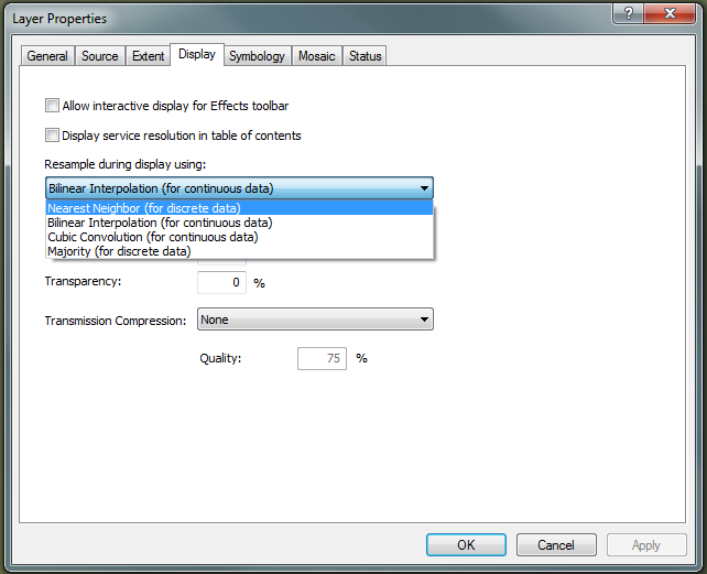
Perfect! That helped. Thank you Timothy!