- Home
- :
- All Communities
- :
- Products
- :
- Data Management
- :
- Data Management Questions
- :
- ArcGIS Pro: Create Space Time Tool/Time field
- Subscribe to RSS Feed
- Mark Topic as New
- Mark Topic as Read
- Float this Topic for Current User
- Bookmark
- Subscribe
- Mute
- Printer Friendly Page
ArcGIS Pro: Create Space Time Tool/Time field
- Mark as New
- Bookmark
- Subscribe
- Mute
- Subscribe to RSS Feed
- Permalink
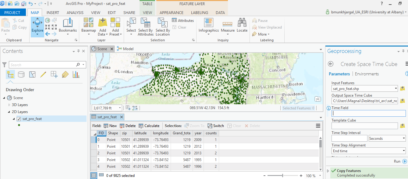
Anyone successfully used Visualize Space Time Cube in 3D tool? In order to do this visualization I needed to use Create Space Time Cube Tool first but stuck at the point to input Time Field. I don't understand how to input my time stamps for all point features in my data. Please help. My data is disease incidence aggregated by ZIP data.
- Mark as New
- Bookmark
- Subscribe
- Mute
- Subscribe to RSS Feed
- Permalink
that covers the spatial component... do you have that data for different time periods?
- Mark as New
- Bookmark
- Subscribe
- Mute
- Subscribe to RSS Feed
- Permalink

Thanks. My data content is ZIP, ZIP centroid (lat&long), ZIP population (grand_tota), 18 years (year), disease incidence per year by each ZIP (counts). I don't know what this Time Field is asking from me. It doesn't have browse option. I am confused.
- Mark as New
- Bookmark
- Subscribe
- Mute
- Subscribe to RSS Feed
- Permalink
ok, you have points, but they need to be in projected coordinates, so project the file, you have some attributes and you have a time field which looks llike 2009, 2012, 2013 for each centroid zip code. The help isn't clear as whether it needs to be a time field or a string representation of the time.
An overview of the Space Time Pattern Mining toolbox—Help | ArcGIS for Desktop
provides more details, but I am suspecting that your time data and its spacing is pretty slim to be of much use for the outputs that it is used for
Create Space Time Cube—Help | ArcGIS for Desktop
Anyway, I will leave that for you to decide so you don't waste time working on something that isn't appropriate for the data that the tool is designed for
- Mark as New
- Bookmark
- Subscribe
- Mute
- Subscribe to RSS Feed
- Permalink
This is not a complete view of my dataset. I have 19 years 1995-2013 and 9950 individual points for all New York State Zip each has disease incident counts for 19 years in total. And I hope my data is then space time and this tool could be suitable. I read all this overviews, none actually tells me what exactly that time field requires for input.
- Mark as New
- Bookmark
- Subscribe
- Mute
- Subscribe to RSS Feed
- Permalink
time is of your choosing... you obviously only have yearly data
- Mark as New
- Bookmark
- Subscribe
- Mute
- Subscribe to RSS Feed
- Permalink
Do you think that yearly data is the problem here?
- Mark as New
- Bookmark
- Subscribe
- Mute
- Subscribe to RSS Feed
- Permalink
It could be the type of field... from the first link they are quite specific about the format... just because a field has a date in it, doesn't mean it is a date field, it could be a numeric or string field masquarading as a date field. The downfall of relying on ones eyes. From the help... you may have to give it good read, I don't have time now, sorry.
- Select a field of type Date for the Time Field parameter. This field should contain the timestamp associated with each point feature.
- Mark as New
- Bookmark
- Subscribe
- Mute
- Subscribe to RSS Feed
- Permalink
No problem. I got your insights. Thanks much.
- Mark as New
- Bookmark
- Subscribe
- Mute
- Subscribe to RSS Feed
- Permalink
Sharing solution would be helpful, I guess. That "Time Field" was to verify whether date variable in my data is in compatible date format. After I tried Convert Date Field in ArcGis Pro to convert my year in text format to YYYY format unsuccessfully, I quit and made the changes in excel sheet using =Date(dd, mm,year) formula. Date field was then finally recognized as a date to Arcgis when I import it and "Time Field" in Create Space Time Cube Tool accepted my input "date1" after all. I then projected and run. My output file was produced in .nc format which I will now use for Cluster Outlier Analysis aka Anselin's Local Moran's I.