- Home
- :
- All Communities
- :
- Products
- :
- Data Management
- :
- Data Management Questions
- :
- ARC GIS won't let me join data
- Subscribe to RSS Feed
- Mark Topic as New
- Mark Topic as Read
- Float this Topic for Current User
- Bookmark
- Subscribe
- Mute
- Printer Friendly Page
ARC GIS won't let me join data
- Mark as New
- Bookmark
- Subscribe
- Mute
- Subscribe to RSS Feed
- Permalink
I have a shape file of all the counties in the United States and data from the 208-2016 United States Presidential Elections. I am trying to join the data so that when I click on the county name, the results for the election will show. I have tried joining by the FIPS code but that doesn't help.
Here is the data if you think you can help me:
- Mark as New
- Bookmark
- Subscribe
- Mute
- Subscribe to RSS Feed
- Permalink
rather than post the large files, perhaps you can just do a screen grab of the two tables that show the fields you are trying to use in the join.
- fields must be of the same type (number or text)
- if one field is text and the other is numeric, then you need to create a new field to use in the join and convert it to text using the field calculator
- values in the fields must have exact matching pairs
- matching pairs for text would include their case ( 'owner' doesn't equal 'Owner')
- partial matches aren't any good
Covers most problems when people are trying to formulate joins
- Mark as New
- Bookmark
- Subscribe
- Mute
- Subscribe to RSS Feed
- Permalink
I got a screenshot. I am trying to link the United States Counties layer and the election results (either csv 1 or 2). Both layers have the fips codes and county names.
- Mark as New
- Bookmark
- Subscribe
- Mute
- Subscribe to RSS Feed
- Permalink
The Excel sheet name in your screenshot and the one attached to your original post, don't seem to be the same.
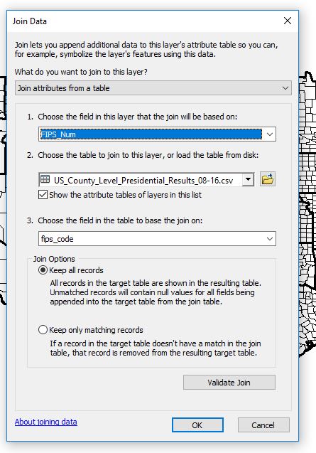
Anyway, as Dan mentioned, you need to make sure the fields you are joining, should have the same Data Type. The Esri Counties data, has FIPS as String(Text), however the one in the excel you show in the screenshot has Long Int. So that join won't work.
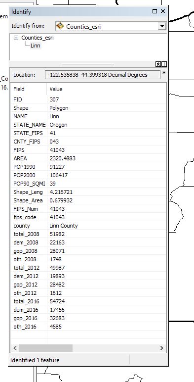
I added a new Column in the Counties Shapefile, FIPS_Num, populated the FIPS code in it from the existing FIPS Code field and that allows the join.
- Mark as New
- Bookmark
- Subscribe
- Mute
- Subscribe to RSS Feed
- Permalink
Thank you for your help. I have tried numerous ways but I can't get the join to work. Do you still have the file?
Thanks for your help.
- Mark as New
- Bookmark
- Subscribe
- Mute
- Subscribe to RSS Feed
- Permalink
I am trying to join Presidential Election data from 2008-2016 from the county level to a shapefile depending on what region they are in. What would I join them to?
- Mark as New
- Bookmark
- Subscribe
- Mute
- Subscribe to RSS Feed
- Permalink
FYI -- Tip --
For those of you who do not know -- The first 8 Rows of an excel spreadsheet determines the datatype... so if you have rows of number but have one blank or text character within the first eight rows that column will be treated as text....in esri ...
- Mark as New
- Bookmark
- Subscribe
- Mute
- Subscribe to RSS Feed
- Permalink
Ditch the csv and use real tables in a file geodatabase.
- Mark as New
- Bookmark
- Subscribe
- Mute
- Subscribe to RSS Feed
- Permalink
I am using the 2010 population as a benchmark for whether a county is rural (2,499 or less), suburban (2500-49,999) and urban (50,000 or more). Is there a way in ARCGIS to make a formula that will automatically divide the counties up?