- Home
- :
- All Communities
- :
- Products
- :
- Data Management
- :
- Data Management Questions
- :
- Alternatives to using SDE command line tools - Blo...
- Subscribe to RSS Feed
- Mark Topic as New
- Mark Topic as Read
- Float this Topic for Current User
- Bookmark
- Subscribe
- Mute
- Printer Friendly Page
Alternatives to using SDE command line tools - Blog Discussion
- Mark as New
- Bookmark
- Subscribe
- Mute
- Subscribe to RSS Feed
- Permalink
http://blogs.esri.com/esri/supportcenter/2013/10/04/do-this-not-that-alternatives-to-using-sde-comma...
We are very interested in hearing feedback from everyone who uses the ArcSDE commands, including questions, concerns, and ideas for making this successful. You can also contact Esri Support Services for specific ArcSDE commands that do not have comparable replacements.
This document outlines the planned changes in platform and functionality in the ArcGIS 10.2 release and
includes a reference to ArcGIS 10.1 deprecation notes.
http://downloads2.esri.com/support/TechArticles/W26496_W25918_DEPRECATION_PLAN_FOR_ARCGIS_101_and_10...
- Mark as New
- Bookmark
- Subscribe
- Mute
- Subscribe to RSS Feed
- Permalink
Andrew - I believe you need to login to the Ideas portal first and then use the URL - this will work.
Here is the title of the Idea on the site that you can also search for.
Add update license tool for enterprise geodatabase before it expires
- Mark as New
- Bookmark
- Subscribe
- Mute
- Subscribe to RSS Feed
- Permalink
This is a great thread, but also very troubling. The most recent info we have from ESRI is:
- We're deprecating command line at 10.2
- Vince Angelo says to register a sql view you need 2 steps - create the view then register it with soon-to-be-deprecated command line
- Drop the spatial index first in order to equate command line load_only. Oh, by the way, this won't work when map services have locks on the data.
- We might have the ability to import/export dbtune past 10.2
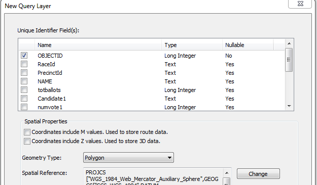
I have to say that ESRI has been most unhelpful in providing info on what's coming up at 10.3 - just look at the number of threads there are on this topic!! Your users rely on the type of spatial views that command line provided, and there is no combination of GP tools that allow you to create an "sde-registered" view. Anyone who says using query layers in place of spatial views is an option seriously needs to go through this dialog when adding 30+ views to an mxd - you'll understand our pain:
It's a joke that ESRI marked this idea as "implemented": ArcGIS Idea - Create SDE spatial view from ArcGIS Desktop
Please ESRI let us know what you have upcoming for 10.3 so we can plan accordingly.
- Mark as New
- Bookmark
- Subscribe
- Mute
- Subscribe to RSS Feed
- Permalink
Nate - Thanks for bringing these concerns to our attention based on your comments.
1 - The commandline tools are deprecated starting at 10.3 release
2 - If you have specific workflows that can only be done through the commandline then please submit a support ticket for these to be investigated.
3 - Have you tried the schemalockingenabled within the map service to see if this helps? I would try this and if not submit this to support so that they are aware the new workflow for setting a layer in load only mode is not comparable to the older commandline tools with the flexibility of data that is being served in a service.
4 - There is a tool for this at 10.3 'Export/Import geodatabase configuration keywords'
For your comment about the database views prompting for the unique identifier field - there is an existing bug for this and we are aware of this issue. I would suggest that you contact support and ask to be added to this bug since there is only the workaround of using the commandline tools to create the view or saving out as a layer file.
NIM085661 - ArcGIS does not set the first not-null field it finds as the unique identifier for a database view.
- Mark as New
- Bookmark
- Subscribe
- Mute
- Subscribe to RSS Feed
- Permalink
Hi Melissa:
Thank you for your response. I hadn't used the schemalockingenabled configuration for services and will definitely look into it. However, the comment made by Tom Weisenberger was that command line sde doesn't care about map service locks in order to drop a spatial index. Does RemoveSpatialIndex_management need an exclusive lock or can it proceed with clients using the target layer?
- Mark as New
- Bookmark
- Subscribe
- Mute
- Subscribe to RSS Feed
- Permalink
Nate -
Did you give the schemalockingenabled a try yet? I did a quick test and this worked for my services accessing data that I wanted to update the spatial index on. The documentation does not state that there is a requirement for an exclusive lock for the 'Remove Spatial Index' tool, but this is in lines with a schema change. This changing from the older commandline tools to be more restrictive would make sense that you would want to direct this to an administrative windows to avoid possible performance issues for users accessing those datasets.
I am wondering if the error message was :
001166 : Spatial index could not be disabled.
ArcGIS Help (10.2, 10.2.1, and 10.2.2) - Rules for working with Schema locks
ArcGIS Help (10.2, 10.2.1, and 10.2.2) - Error 001166
ArcGIS Help (10.2, 10.2.1, and 10.2.2) - Schemalockingenabled
- Mark as New
- Bookmark
- Subscribe
- Mute
- Subscribe to RSS Feed
- Permalink
Here is another scenario we ran into today that required command line tools. ArcSDE 10.0 sp4 on Oracle 11.2.0.3.0
AIX 6.1.Client is ArcGIS desktop 10.2.
1) Existing feature class xx, versioned, used to be part of a replica but isn't any more (deregistered on both ends)
2) New feature class loaded to replace it, different table structure, copied into geodatabase as xx_n.
3) Operator tries to rename xx to xx_o without de-versioning (oops). Multiple problems ensue, and xx_n cannot be renamed to xx. No combination of delete, reload, rename using ArcCatalog is solving. Looks like corruption of repository.
4) After "deleting" feature class via ArcCatalog, sde command line sdetable -o create used to create table xx, and sdelayer -o add used to add shape field.
5) Back in ArcCatalog, register xx as versioned, deregister, rename as xx_o. Rename xx_n to xx, delete xx_o. All is well.
This sort of problem with renaming objects happens with some frequency (at least once or twice a year). How are we going to recover when command line goes away? Using a new name for the object in many cases would be extremely painful due to multiple map and application dependencies across several organizations.
- Mark as New
- Bookmark
- Subscribe
- Mute
- Subscribe to RSS Feed
- Permalink
We've encountered similar circumstances with complex objects like topologies and geometric networks. Once a delete or rename fails, the only way to clear the layer out of the table registry is sdetable -o delete. If the table is not found, you're prompted to continue to remove metadata about the table (which removes the entry from the sde table registry if possible):
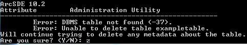
If not for command line, how are we to remove orphaned table registry items? Does Delete_management have a similar table registry removal function?
- Mark as New
- Bookmark
- Subscribe
- Mute
- Subscribe to RSS Feed
- Permalink
For me its create_view
When we try to create_views directly in sql with st_geometry we get "abstract_data_types not supported". Our only work around the commandline tools. Until then, we will not upgrade.
- Mark as New
- Bookmark
- Subscribe
- Mute
- Subscribe to RSS Feed
- Permalink
What RDBMS are you using? I always define my views with SQL, then register with 'sdelayer -o register', and I've never seen that error. 'sdetable -o create_view' is only really for use with the rarely-used SDEBINARY geometry storage.
- V
- Mark as New
- Bookmark
- Subscribe
- Mute
- Subscribe to RSS Feed
- Permalink
Oracle, with ST_GEOMETRY