Turn on suggestions
Auto-suggest helps you quickly narrow down your search results by suggesting possible matches as you type.
Cancel
- Home
- :
- All Communities
- :
- Products
- :
- Data Management
- :
- Data Management Questions
- :
- �??Address locator style�?� to locate the distance...
Options
- Subscribe to RSS Feed
- Mark Topic as New
- Mark Topic as Read
- Float this Topic for Current User
- Bookmark
- Subscribe
- Mute
- Printer Friendly Page
�??Address locator style�?� to locate the distance from the start of the street,
Subscribe
7450
16
11-09-2013 11:15 PM
11-09-2013
11:15 PM
- Mark as New
- Bookmark
- Subscribe
- Mute
- Subscribe to RSS Feed
- Permalink
�??Address locator style�?� to locate the distance from the start of the street,
This is the second time I�??m highlighting this issue.
My issue here is that I need �??address locator�?� that can find a point on astreet according to its distance from the start of it (street). The start\end of the street is based on the direction of the digitizing
For example, if I need to find the address �??55 Al Irsal St�?� then the system should measure the distance from the start of the road and �??walk�?� 55 meters and stops there (screenshot below).
[ATTACH=CONFIG]28985[/ATTACH]
This fashion of �??address locators�?� sound not to be available at the moment in the ArcGIS package.
You contribution is highly appreciated
Thank you
Best
Jamal
----------------------------------------
Jamal Numan
Geomolg Geoportal for Spatial Information
Ramallah, West Bank, Palestine
Jamal Numan
Geomolg Geoportal for Spatial Information
Ramallah, West Bank, Palestine
16 Replies
11-10-2013
10:57 AM
- Mark as New
- Bookmark
- Subscribe
- Mute
- Subscribe to RSS Feed
- Permalink
Jamal,
I'm not sure whether such address locator is available. If your task is not specific to Geocoding, then you can try Route Analysis.
I'm not sure whether such address locator is available. If your task is not specific to Geocoding, then you can try Route Analysis.
11-10-2013
12:07 PM
- Mark as New
- Bookmark
- Subscribe
- Mute
- Subscribe to RSS Feed
- Permalink
Jamal,
I'm not sure whether such address locator is available. If your task is not specific to Geocoding, then you can try Route Analysis.
Thanks Nidhin,
In any route analysis you need first to specify the first address and then the second address and next to tell the system to find the best route for you!
Geocoding does help specifying addresses locations based on, for example, building number and street name.
If you provide building number and street name that are originally stored in two fields in the (street layer or building layer) then the system will be able to locate this address. After locating two addresses, the route can be used to find the best path in terms of time or distance
What I�??m looking for is a locator that reads the length and the name of the street such that if the value �??55 Al Irsal St�?�, then the system will locate it in its correct position in the street (55 meters from the start of the Al Irsal St)
----------------------------------------
Jamal Numan
Geomolg Geoportal for Spatial Information
Ramallah, West Bank, Palestine
Jamal Numan
Geomolg Geoportal for Spatial Information
Ramallah, West Bank, Palestine
11-11-2013
06:31 AM
- Mark as New
- Bookmark
- Subscribe
- Mute
- Subscribe to RSS Feed
- Permalink
Hi Jamal
You can achieve what you are looking for if you synthesize single-address ranges for your data. First unsplit the roads based on street name and connectivity (Unsplit Line tool) then calculate start (0) and end (integer value of length in metres) 'address' fields onto the lines and use them as from and to address ranges. Geocodes will land on the lines, not to each side.
Regards
11-11-2013
09:01 AM
- Mark as New
- Bookmark
- Subscribe
- Mute
- Subscribe to RSS Feed
- Permalink
Hi Jamal
You can achieve what you are looking for if you synthesize single-address ranges for your data. First unsplit the roads based on street name and connectivity (Unsplit Line tool) then calculate start (0) and end (integer value of length in metres) 'address' fields onto the lines and use them as from and to address ranges. Geocodes will land on the lines, not to each side.
Regards
Thank you Bruce for the help,
Do you mean �??US Address �?? one range�?� address locator style?
However, sounds not to achieve what I�??m looking for.
Example,
In the attached screenshot I have a street named Al Irsal with total length of 278 meters (obtained from the automatcis shape_lenght field). Simply, what I need is to search any value in that street based on:
1. The name of the street
2. The distance from the start of the road to the target (the start of the street is defined based on the direction of digitizing)
In this case,
If I search for the address 119 Al Irsal street, then the location should be as shown in the screenshot below
[ATTACH=CONFIG]29019[/ATTACH]
Similarly, searching for the address 208 Al Irsal street will produce the location below
[ATTACH=CONFIG]29020[/ATTACH]
Which address locator style can handle this scenario?
----------------------------------------
Jamal Numan
Geomolg Geoportal for Spatial Information
Ramallah, West Bank, Palestine
Jamal Numan
Geomolg Geoportal for Spatial Information
Ramallah, West Bank, Palestine
11-11-2013
09:44 AM
- Mark as New
- Bookmark
- Subscribe
- Mute
- Subscribe to RSS Feed
- Permalink
Which address locator style can handle this scenario?
Jamal,
What Bruce suggests, is that you create "fake" From_Addr and To_Addr fields based on the length of the lines, instead of inserting real address numbers.
- That is, the From_Addr field will in your case always be 0, use the Calculate Field tool to set it 0 if it already isn't.
- The To_Addr will be the length of the road line, calculated by using the Calculate Field tool, and inserting a calculation statement like To_Addr = !Shape_Length! (when using Python)
In order for this to work properly, and assuming you really do have distance measurement for each address, and that all road segments belonging to the same road (e.g. Al Irsal street) are measured continuously (distance measurements for addresses continue after a junction if still on the same road (e.g. Al Irsal street), than you need to make sure that "roads" are not split by junctions, but are physically continuing lines in order to calculate a proper To_Addr value (shape length).
This is why Bruce reffered to the Unsplit Line Tool, a tool that merges individual line segment into one longer line based on a "dissolve field", in your case the road names.
If instead, all of your measurements and roads stop at junctions (and roads that may continue beyond a junction have for example an individual index number (Al Irsal_1, Al Irsal_2, etc.), than you can probably skip using the Unsplit Line tool, and simply calculate the To_Addr field based on the existing lines' shape lengths.
But this second option is probably less likely.
11-11-2013
10:29 AM
- Mark as New
- Bookmark
- Subscribe
- Mute
- Subscribe to RSS Feed
- Permalink
Jamal,
What Bruce suggests, is that you create "fake" From_Addr and To_Addr fields based on the length of the lines, instead of inserting real address numbers.
- That is, the From_Addr field will in your case always be 0, use the Calculate Field tool to set it 0 if it already isn't.
- The To_Addr will be the length of the road line, calculated by using the Calculate Field tool, and inserting a calculation statement like To_Addr = !Shape_Length! (when using Python)
In order for this to work properly, and assuming you really do have distance measurement for each address, and that all road segments belonging to the same road (e.g. Al Irsal street) are measured continuously (distance measurements for addresses continue after a junction if still on the same road (e.g. Al Irsal street), than you need to make sure that "roads" are not split by junctions, but are physically continuing lines in order to calculate a proper To_Addr value (shape length).
This is why Bruce reffered to the Unsplit Line Tool, a tool that merges individual line segment into one longer line based on a "dissolve field", in your case the road names.
If instead, all of your measurements and roads stop at junctions (and roads that may continue beyond a junction have for example an individual index number (Al Irsal_1, Al Irsal_2, etc.), than you can probably skip using the Unsplit Line tool, and simply calculate the To_Addr field based on the existing lines' shape lengths.
But this second option is probably less likely.
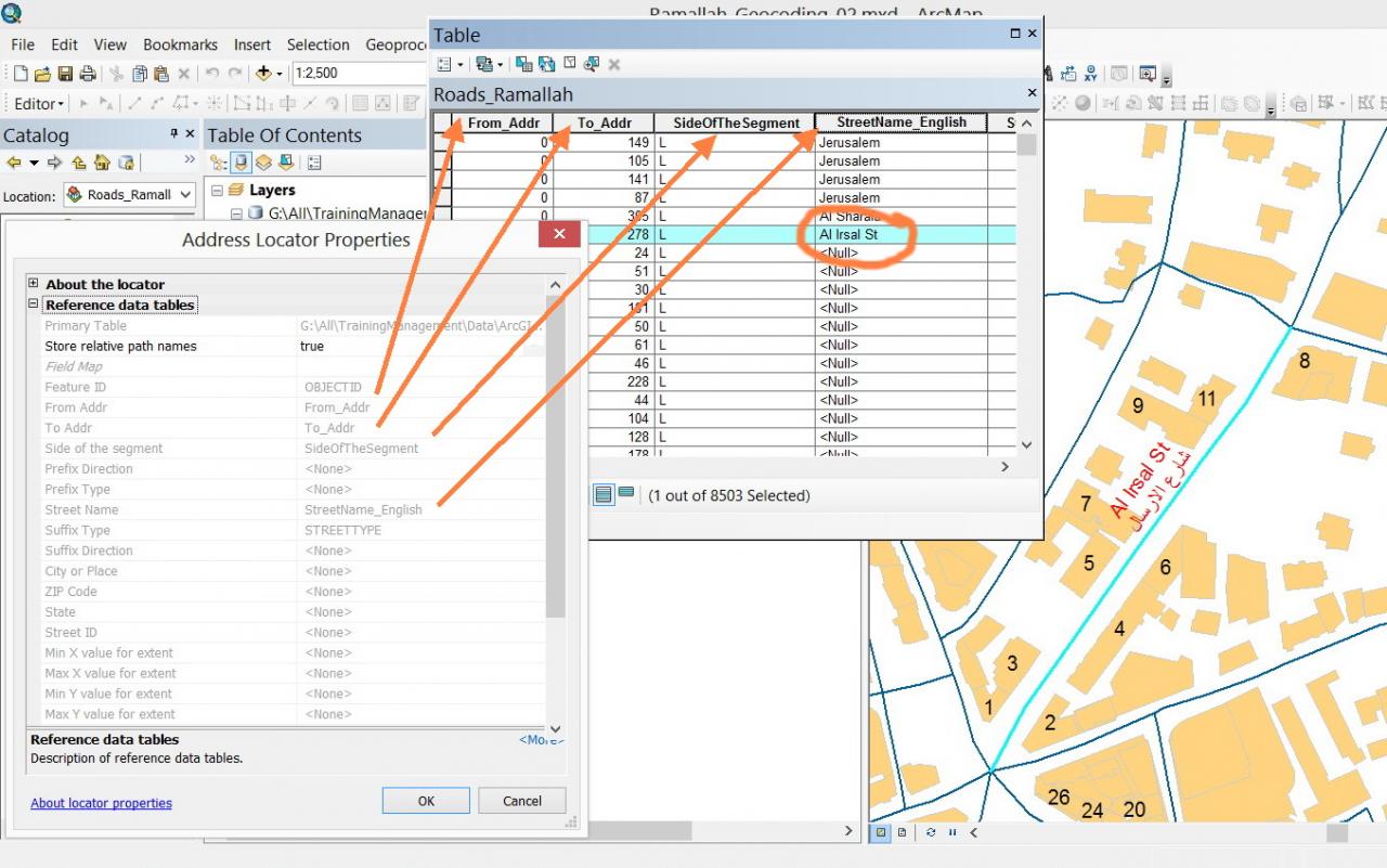
Many thanks Marco for the valuable input,
I have created original data that fits the �??US Address �??One Range�?� address locator style that includes compulsorily fields for
From Addr
To Addr
Side of the segment
Street name
1. I couldn�??t figure out which data must be stored in the �??Side of the segment�?� field?
2. I�??m aware of the issue of �??unsplit�?�. Each street name must have single feature or otherwise I may go for the scenario that you have already introduced (Al Irsal_1, Al Irsal_2, etc.)
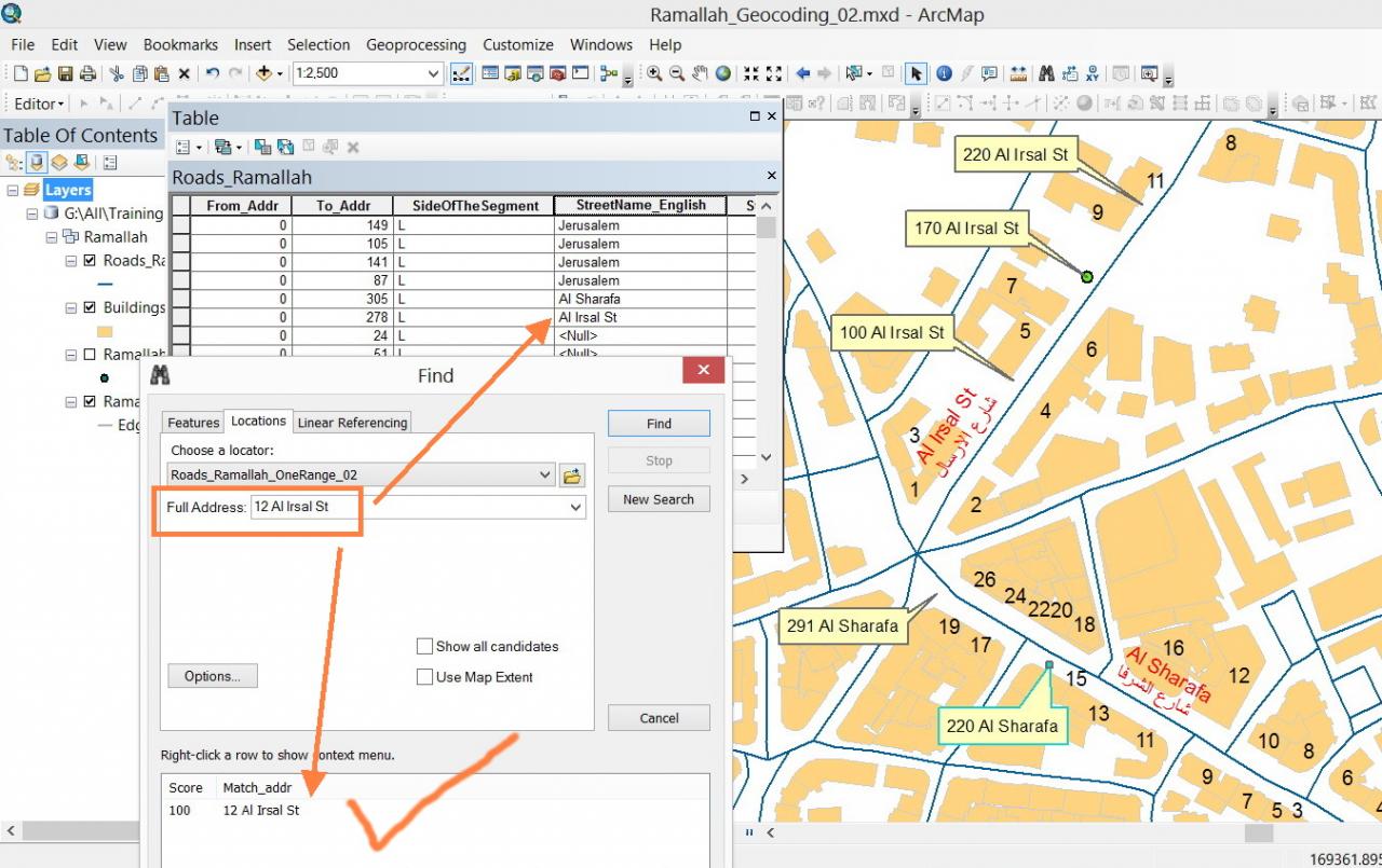
3. I used the �??find�?� tool to search for addresses based on �??US Address �??One Range�?� address locator style i have already created.
[ATTACH=CONFIG]29021[/ATTACH]
�?� I search some addresses in the �??Al Irsal Street�?� and it works fine for the �??even�?� numbers and fails to find addresses with �??odd�?� numbers!
[ATTACH=CONFIG]29022[/ATTACH], [ATTACH=CONFIG]29023[/ATTACH]
What might be the issue here?
�?� In return, in case of �??Al Sharafa Street�?� the system could search for both even and odd numbers.
[ATTACH=CONFIG]29024[/ATTACH], [ATTACH=CONFIG]29025[/ATTACH]
What might be the explanation?
----------------------------------------
Jamal Numan
Geomolg Geoportal for Spatial Information
Ramallah, West Bank, Palestine
Jamal Numan
Geomolg Geoportal for Spatial Information
Ramallah, West Bank, Palestine
11-11-2013
11:46 PM
- Mark as New
- Bookmark
- Subscribe
- Mute
- Subscribe to RSS Feed
- Permalink
What I�??m looking for is a locator that reads the length and the name of the street such that if the value �??55 Al Irsal St�?�, then the system will locate it in its correct position in the street (55 meters from the start of the Al Irsal St)
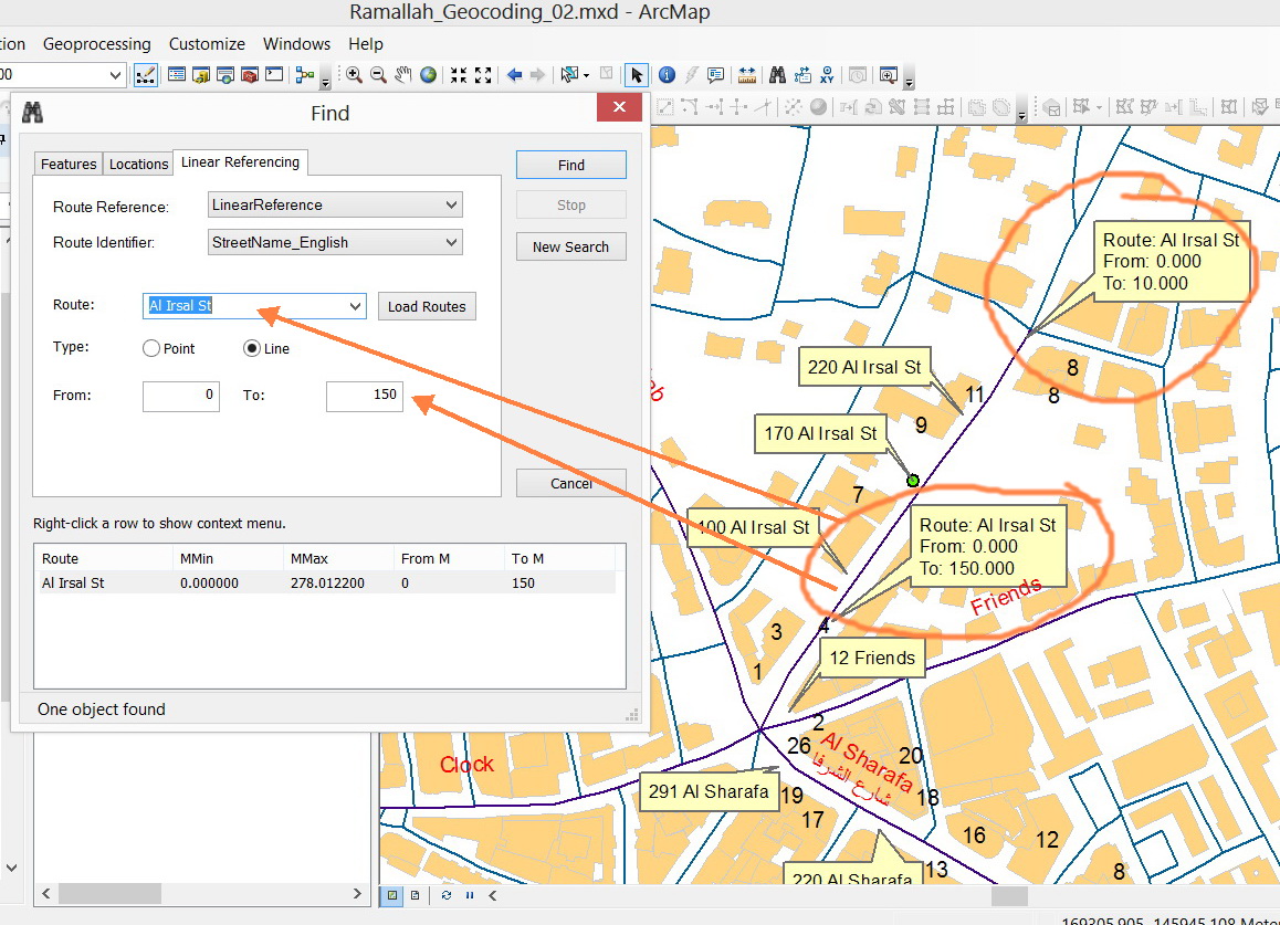
Jamal, this requirement of "distances" fitted on lines, although probably full fillable by Geocoding by manipulating the parameters, is actually not so much a "Geocoding" question (where you attempt to put addresses on lines), but a form of Linear Referencing or Dynamic Segmentation with Point events.
See:
What is linear referencing?
Dynamic Segmentation
For this to work in your case, the road names would need to determine what are the individual routes, and you set the begin and end "M values" like in my previous post.
11-12-2013
11:29 AM
- Mark as New
- Bookmark
- Subscribe
- Mute
- Subscribe to RSS Feed
- Permalink
Jamal, this requirement of "distances" fitted on lines, although probably full fillable by Geocoding by manipulating the parameters, is actually not so much a "Geocoding" question (where you attempt to put addresses on lines), but a form of Linear Referencing or Dynamic Segmentation with Point events.
See:
What is linear referencing?
Dynamic Segmentation
For this to work in your case, the road names would need to determine what are the individual routes, and you set the begin and end "M values" like in my previous post.
Thank you macro for the input,
[ATTACH=CONFIG]29061[/ATTACH]
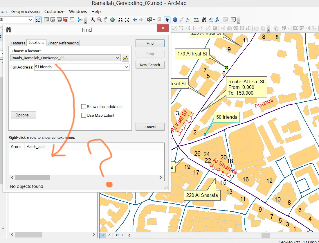
Please, consider that I�??m planning to publish the geocoding service by the ArcGIS server and then to plug it in my web application. The end user is assumed to provide the distance and street name and then the system is expected to zoom to that location.
So for example, if the end user provides �??130 Al Irsal St�?� then the web application is supposed to zoom to that particular location as I have already illustrated.
We were close to what I was looking for when using the US Address �??One Range�?� address locator style except one thing:
sometimes, the odd values are not found
For example:
The system can find �??50 Friends�?� street
[ATTACH=CONFIG]29059[/ATTACH]
But not �??91 Friends�?� street
[ATTACH=CONFIG]29060[/ATTACH]
What might be the issue? Why the odd numbers are not found?
----------------------------------------
Jamal Numan
Geomolg Geoportal for Spatial Information
Ramallah, West Bank, Palestine
Jamal Numan
Geomolg Geoportal for Spatial Information
Ramallah, West Bank, Palestine
11-13-2013
01:15 AM
- Mark as New
- Bookmark
- Subscribe
- Mute
- Subscribe to RSS Feed
- Permalink
We were close to what I was looking for when using the US Address �??One Range�?� address locator style except one thing:
sometimes, the odd values are not found
...
What might be the issue? Why the odd numbers are not found?
I have no explanation (yet), but have you tried the "Show all candidates" option on the Find dialog, and does it also fail to show any "candidate" address locations?