- Home
- :
- All Communities
- :
- User Groups
- :
- Coordinate Reference Systems
- :
- Questions
- :
- Shapefile displaying data in the incorrect locatio...
- Subscribe to RSS Feed
- Mark Topic as New
- Mark Topic as Read
- Float this Topic for Current User
- Bookmark
- Subscribe
- Mute
- Printer Friendly Page
Shapefile displaying data in the incorrect location on map (off by approx 10m)
- Mark as New
- Bookmark
- Subscribe
- Mute
- Subscribe to RSS Feed
- Permalink
- Report Inappropriate Content
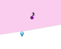
I have a shapefile in ITM and I brought it into ARCGIS. In ARCGIS Pro some of the layers are in ITM and ome are Irish Grid. I ahve changed the basemap to ITM. I thought the shapefile was slightly off as one of the points were within a buffer when I knew it shouldn't be (purple icon). As the shapefile only had four points. I created an excel sheet with the four points and added them to the map (Blue icon). These locations have mapped correctly.
- Mark as New
- Bookmark
- Subscribe
- Mute
- Subscribe to RSS Feed
- Permalink
- Report Inappropriate Content
check to see if there is a difference in the reference datum
... sort of retired...
- Mark as New
- Bookmark
- Subscribe
- Mute
- Subscribe to RSS Feed
- Permalink
- Report Inappropriate Content
Thanks for the response.
I created the excel file points (blue icon) from the coordinates in the
attribute table of the shapefile (pink icon).
Is this what you mean regarding reference datum? If not how do I check this?
I’m very new to ARCGIS!!!
From: Dan Patterson <geonet@esri.com>
Sent: Thursday 27 August 2020 11:36
To: Sarah Moore <smoore@jodireland.com>
Subject: Re: - Re: Shapefile displaying
data in the incorrect location on map (off by approx 10m)
GeoNet, The Esri Community | GIS and Geospatial Professional Community
<https://community.esri.com/?et=watches.email.thread>
Re: Shapefile displaying data in the incorrect location on map (off by
approx 10m)
reply from Dan Patterson
<https://community.esri.com/people/danretired?et=watches.email.thread>
in *Coordinate
Reference Systems* - View the full discussion
<https://community.esri.com/message/950403-re-shapefile-displaying-data-in-the-incorrect-location-on-map-off-by-approx-10m?commentID=950403&et=watches.email.thread#comment-950403>
- Mark as New
- Bookmark
- Subscribe
- Mute
- Subscribe to RSS Feed
- Permalink
- Report Inappropriate Content
Sarah... ITM? (Irish transverse mercator???) vs Irish Grid. Both are coordinate systems, but there is an underlying "datum", that would define the basis for the coordinate system. WGS84 datum is an example. Datum differences can cause small shifts in the coordinates. You need to provide more information on the coordinate systems that are being used. Excel coordinates would need to have been "defined". What exactly did you do to get the coordinates on the map? If you used "defaults" because you weren't sure, those defaults (basically assumptions) might not properly describe the coordinates and you may need to use the "Define Projection" in Arctoolbox to fix the situation once the problem is narrowed down
... sort of retired...
- Mark as New
- Bookmark
- Subscribe
- Mute
- Subscribe to RSS Feed
- Permalink
- Report Inappropriate Content
I used ITM Coordinates with the excel file and when I displayed the points
I selected ITM as the coordinate system.
The shapefile automatically displayed and It was ITM.
I had exported the shapefile in ITM and I have just bought it in again and
it is now displaying in the correct location.
Not sure what happened there!!
From: Dan Patterson <geonet@esri.com>
Sent: Thursday 27 August 2020 11:52
To: Sarah Moore <smoore@jodireland.com>
Subject: Re: - Re: Shapefile displaying
data in the incorrect location on map (off by approx 10m)
GeoNet, The Esri Community | GIS and Geospatial Professional Community
<https://community.esri.com/?et=watches.email.thread>
Re: Shapefile displaying data in the incorrect location on map (off by
approx 10m)
reply from Dan Patterson
<https://community.esri.com/people/danretired?et=watches.email.thread>
in *Coordinate
Reference Systems* - View the full discussion
<https://community.esri.com/message/950447-re-shapefile-displaying-data-in-the-incorrect-location-on-map-off-by-approx-10m?commentID=950447&et=watches.email.thread#comment-950447>
- Mark as New
- Bookmark
- Subscribe
- Mute
- Subscribe to RSS Feed
- Permalink
- Report Inappropriate Content
at least it works now... stranger things have happened 
... sort of retired...