- Home
- :
- All Communities
- :
- User Groups
- :
- Coordinate Reference Systems
- :
- Questions
- :
- Use of polynomial function equation for grid trans...
- Subscribe to RSS Feed
- Mark Topic as New
- Mark Topic as Read
- Float this Topic for Current User
- Bookmark
- Subscribe
- Mute
- Printer Friendly Page
Use of polynomial function equation for grid transformation
- Mark as New
- Bookmark
- Subscribe
- Mute
- Subscribe to RSS Feed
- Permalink
I have a cartographic project in Greece. The raster data go back in' 50s and '60s. That time the geographic system that was used was HATT (hellenic azimuthial). As a result the most of my raster file use that strange grid. The greek military geography service has published a method for the transformation of the hatt grid data to Greek Grid (2100). This method uses 2nd degree polyonomial function as you can see bellow
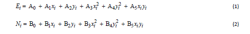
Where:
Αx and Bx are factors given by GMS
Χi, Yi the coordinates in HATT system and
Ei,Ni the result coordinates in Greek Grid (epsg 2100).
It a problem that i can solve easily in excel but i need to create a custom transformation to use with raster data.
unfortunately CreateCustomGeoTransformation doesn't seem to support a custom equation only the following
Geocentric_Translation, Molodensky, Molodensky_Abridged, Position_Vector, Coordinate_Frame, Molodensky_Badekas, NADCON, HARN, NTV2, Longitude_Rotation, Unit_Change, and Geographic_2D_Offset
Any ideas?
- Mark as New
- Bookmark
- Subscribe
- Mute
- Subscribe to RSS Feed
- Permalink
I'm sorry that I didn't reply earlier.
Yes, that's correct. We currently don't support any polynomial transformations in the Esri projection engine. It's possible that's there's a way do a custom transformation using raster functions/tools but I don't know offhand how it would be done.
Another possibility would be to build a grid of offsets using the polynomial equations and then use the grid (raster) to convert the maps or convert the offsets to use a lat/lon grid file. For the latter make a NTv2 grid or NADCON-style files--then you could use the Create Custom Geographic Transformation tool.
Melita