- Home
- :
- All Communities
- :
- User Groups
- :
- Coordinate Reference Systems
- :
- Questions
- :
- How to find the unknown coordinates reference syst...
- Subscribe to RSS Feed
- Mark Topic as New
- Mark Topic as Read
- Float this Topic for Current User
- Bookmark
- Subscribe
- Mute
- Printer Friendly Page
How to find the unknown coordinates reference system for my map data
- Mark as New
- Bookmark
- Subscribe
- Mute
- Subscribe to RSS Feed
- Permalink
I have several shapesfiles which perfectly overlay but the coordinates reference system is unknown. I need to overly these with other data in a differetn coordinate system. The coordinate extent is quite unique. I tried initially to overlay with several projected and geographic coordinates systems associated with the area out of which two showed very close displacement (about 60m). Next i tried different datum with one of the 'promising' coordinates reference systems (a geographic coordinates system) and also change the units but same results. Attached is a clip of two of the coordinate extents. I am yet to try the second 'promising' CRS but decided to put it out just in case i am missing something
- Mark as New
- Bookmark
- Subscribe
- Mute
- Subscribe to RSS Feed
- Permalink
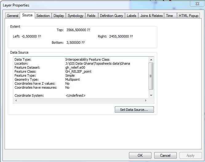
Curtis, is it the same transformation found in Layer properties? The latest is the data had a coordinate reference system but because it is in the .e00 format i had to use the conversion tool before it could display in arcmap. So i customized the coordinate reference system in arcmap but have not been able able to project it into a common projection system with the rest of my data. I have tried different approaches with the transformation but its not working.
- « Previous
- Next »
- « Previous
- Next »