- Home
- :
- All Communities
- :
- User Groups
- :
- Coordinate Reference Systems
- :
- Questions
- :
- Re: How to find the unknown coordinates reference ...
- Subscribe to RSS Feed
- Mark Topic as New
- Mark Topic as Read
- Float this Topic for Current User
- Bookmark
- Subscribe
- Mute
- Printer Friendly Page
How to find the unknown coordinates reference system for my map data
- Mark as New
- Bookmark
- Subscribe
- Mute
- Subscribe to RSS Feed
- Permalink
I have several shapesfiles which perfectly overlay but the coordinates reference system is unknown. I need to overly these with other data in a differetn coordinate system. The coordinate extent is quite unique. I tried initially to overlay with several projected and geographic coordinates systems associated with the area out of which two showed very close displacement (about 60m). Next i tried different datum with one of the 'promising' coordinates reference systems (a geographic coordinates system) and also change the units but same results. Attached is a clip of two of the coordinate extents. I am yet to try the second 'promising' CRS but decided to put it out just in case i am missing something
- Mark as New
- Bookmark
- Subscribe
- Mute
- Subscribe to RSS Feed
- Permalink
Neil, I must say although i have 'self-thought' to do a lot with my data, i am a bit of a novice. But you are right, the data is old as it was in the .E00 format which i converted to shape file formate using the conversion tool in toolbox in arc catalog before opening in arcmap. I will also follow your suggestion and see what i get. Anyway this information is quite interesting. I will have to figure out how to make it useful.
- Mark as New
- Bookmark
- Subscribe
- Mute
- Subscribe to RSS Feed
- Permalink
Love the story about the early surveyors tying ropes to pigs tails....
- Mark as New
- Bookmark
- Subscribe
- Mute
- Subscribe to RSS Feed
- Permalink
Neil, i followed up on it using two transformation systems GCS_north_America_1927 and the 1973 version. Using the +- X as indicated by Capt Wood, but the same results. The only change was when i changed the units from m to Km, but again this is not enough to overlay. My final try is to contact the source of the data and hope i get somebody to respond. Thanks for support
- Mark as New
- Bookmark
- Subscribe
- Mute
- Subscribe to RSS Feed
- Permalink
If the data are for Ghana, you would be advised to use transformations appropriate for that area rather than those associated with North America
- Mark as New
- Bookmark
- Subscribe
- Mute
- Subscribe to RSS Feed
- Permalink
Dan, you may be right. ArcGIS gave three alternatives in the convert from (Geographic coordinates system transformation) under Data frame properties, the first was Leigon which is the geographic RS for Ghana Meter Grid, accordingly these will be the set from which a transformation could be carried out. So thats how come i chose to work with the later two which are north A coordinates. I did not however try it at all with the Leigon, i will and see what happens.
- Mark as New
- Bookmark
- Subscribe
- Mute
- Subscribe to RSS Feed
- Permalink
Kofi,
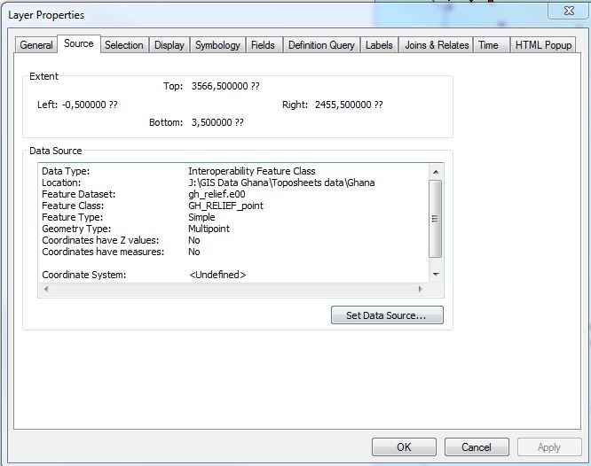
I think you had better start again. NAD certainly isn't appropriate for your data (Ghana).
What is the coordinate system of your modern reference data?
Navigate to a feature class using ArcCatalog, right click on it to get the properties page, look at the coord tab.
What does it say there. Please post a snap shot.
The old e00 data, import it into a file geo db please. Do the same, what are the extents, what do the numbers look like (ie small numbers, maybe degrees, or larger numbers, probably some sort of projected metres.
And please don't mess with units (km), until we have the basics sorted out.
- Mark as New
- Bookmark
- Subscribe
- Mute
- Subscribe to RSS Feed
- Permalink
Neil, thanks for that eye opener, you are very correct, i should have tried transformations between Leigon and others associated with Ghana rather than the North American.
- Mark as New
- Bookmark
- Subscribe
- Mute
- Subscribe to RSS Feed
- Permalink
Kofi,
It may be time to try to look at Fundamentals of georeferencing a raster dataset—Help | ArcGIS for Desktop
and find some well known locations on an image or data set that does have the projection you want, and the data that is unknown. You can create links between the sets and have the new data rubbersheet to the known layer.
It may be that the coordinate system that was used with the .e00 datasets was a totally "local" system. You asked Melita above,why they all would line up line up if there wasn't a coordinate/reference system.....one possibility (and very likely since the data was in an .e00 format which is the ArcInfo Coverager exchange format) is one of the layers, maybe the imagery, was scanned or digitized in local coordinates, and everything was set to match. That would explain why they match up.
One other thing to check, since it is an old coverage, once you import the coverage....check the folder on the disc for a .prj or similar file. The projection info may reside in the file but since it is the older format, ArcMap/Catalog will not recognize it. However, it may give you a clue as to the parameters used....which may help in tracking down the coordinate system or project, IF on was used (and not local as listed above).
- Mark as New
- Bookmark
- Subscribe
- Mute
- Subscribe to RSS Feed
- Permalink
Rebecca, l followed your advice and that from others and have made progress. Yes i used the conversion tool in the Toolbox in Arc catalog and from the output i obtained the coordinate reference system information: I built a custom projection system and all the layers overlaid. Know i am using the project tool in Arcmap to change the coordinates to unify it with the rest of my data, and that is taking two days, and still counting. I think i will post details of the processes i used when i am done.
- Mark as New
- Bookmark
- Subscribe
- Mute
- Subscribe to RSS Feed
- Permalink
All the comments have been useful , i think i have made progress. When i am done i will post the stages involved. I have been able to identify the unknown coordinates system, I built a custom projection system and assigned a coordinates projection system to the data. I am now using the project tool to change the coordinates to unify with the rest of my data. That is taking a bit too long though (two days and still counting).