- Home
- :
- All Communities
- :
- User Groups
- :
- Coordinate Reference Systems
- :
- Blog
- :
- Geodesic distances: How long is that line again?
Geodesic distances: How long is that line again?
- Subscribe to RSS Feed
- Mark as New
- Mark as Read
- Bookmark
- Subscribe
- Printer Friendly Page
What are Geodesic distances?
A geodesic line is the shortest path between two points on a curved surface, like the Earth. They are the analogue of a straight line on a plane surface or whose sectioning plane at all points along the line remains normal to the surface. It is a way of showing distance on an ellipsoid whilst that distance is being projected onto a flat surface.
However there are several types of lines that have different definitions which are listed at the bottom of this blog.
Here's a video example of a geodesic line, the longest geodesic line possible without touching land.
The below image shows a planar distance in orange and the geodesic distance of that planar distance in blue. The maximum deviation of the geodesic from the planar line is near 2,000 Km and the difference in length is 644 Km.
What this image represents is the actual path taken (geodesic line) if I travel in a straight line, relative to me with no turns, from London to Singapore along the International 1924 ellipsoid (this is what I displayed the map in ArcGIS in EPSG:4022).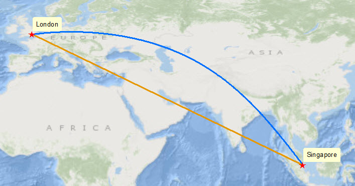
This type of measurement forms part of a series of geodetic features whose measurements account for the distortion of projected space. The distortion of a sphere into 2D space is nicely visualized in the video below:
Jarke J. van Wijk | Mathematical Art Galleries
Why is this important?
Apart from what can be very large differences between geodetic and planar measurements, see the above example, in the real world these differences can have a legal consequence such as those seen in constructing license areas for oil and gas exploration and production, international boundaries and exclusive economic zones.
An example of geodesic line constructions having a political role is seen in the Beaufort Sea International Border dispute between Canada (Canadian Yukon) and The United States (Alaska). The maritime boundary between the two countries has been defined differently. Canada claims the boundary to be along the 141st meridian west out to a distance of 200 nautical miles, following the Alaska-Yukon land border (this is derived from the 1825 boundary treaty between Great Britain and Russia). The United States on the other hand define the boundary line as stretching out to 200 nautical miles perpendicular to the coast whilst being equidistant from the coast.
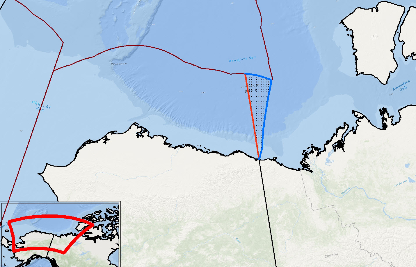
Red line is the Canadian boundary, Blue line the USA boundary and the stippled area is claimed by both parties.
Building Geodetic distances in ArcGIS
The features you draw in a normal ArcMap edit session are not geodetic (they are planar) unless you create them using either the Advanced Editor Construct Geodetic tool or one of the following geoprocessing tools: Bearing Distance To Line, Table To Ellipse, or XY To Line. Geodetic features do not account for changes in terrain, this is a topic for another blog.
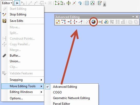
The Construct Geodetic tool is found in the "Advanced Editing" toolbar.
 Here I shall make the Canadian border line which is defined as 200 nautical miles offshore along the Canadian-US border following the 141st Meridian Line.
- First I specify the line type (note the other types defined below)
- Use the snapping tool to add my start vertex to the end of the border
- Change the segment type to Distance - Direction and specify the distance covered (changing it to Nautical Miles)
- Specify the direction of the line
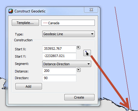 Now the line is constructed according to the chosen ellipsoid and is saved as a new feature upon saving edits.
Some terms used in ArcGIS:
Taken from About geodetic features
- Geodesic line—The shortest line between any two points on the Earth's surface on a spheroid (ellipsoid). One sample use for a geodesic line is when you want to determine the shortest distance between two cities for an airplane's flight path. Another example is the creation of the path between the point of impact and the point of origin of a missile. This is also known as a great circle line if based on a sphere, rather than an ellipsoid. The geodesic line type allows you to create lines only. In addition, you can create a multi-segment line which is a series of geodesic lines that make up a single line feature. You can use a multi-segment line when you want to create an airplane's flight path with waypoints, such as an air route with multiple stops that make up a full route.
- Geodesic circle—A shape whose edge is defined as a particular geodetic distance from a fixed point. Depending on the coordinate system in which it is displayed, it may not appear to be a circle. You might use this if you are creating a range ring of a weapon system, such as to show a weapon's effective range. Geodesic circles can be used to create either lines or polygons.
- Geodesic ellipse—A shape whose sum of geodetic distances from a fixed pair of points is a constant. You could use this to create a signal error ellipse. This is also known as a geodesic circle when the major and minor axes are the same length. The geodesic ellipse type allows you to create lines or polygons.
- Great elliptic—The line on a spheroid (ellipsoid) defined by the intersection at the surface by a plane that passes through the center of the spheroid and the start and end points of a segment. This is also known as a great circle when a sphere is used. The great elliptic type allows you to create lines only.
- Loxodrome—A loxodrome is not the shortest distance between two points, but instead defines the line of constant bearing, or azimuth. Great circle routes are often broken into a series of loxodromes, which simplifies navigation. This is also known as a rhumb line. The loxodrome type allows you to create lines only.
Something extra to try:
A cool app to see the effect of the project on a straightline:
Courtesy of The Magiscian | DIY maps, geoapps, discoveries … and magic in geography
You must be a registered user to add a comment. If you've already registered, sign in. Otherwise, register and sign in.