- Home
- :
- All Communities
- :
- User Groups
- :
- Coordinate Reference Systems
- :
- Blog
- :
- Adding a Newer Coordinate System Definition to an ...
Adding a Newer Coordinate System Definition to an Older Version of ArcMap
- Subscribe to RSS Feed
- Mark as New
- Mark as Read
- Bookmark
- Subscribe
- Printer Friendly Page
Let’s say the latest version of ArcMap includes the definition of your country’s latest coordinate system and you would like to use it in your version of ArcMap. For that you need to export the new definition and import the coordinate system to your software. In this post, I demonstrate how you can perform this operation using the example of GDA2020 VicGrid (EPSG::7899) coordinate system used in Australia.
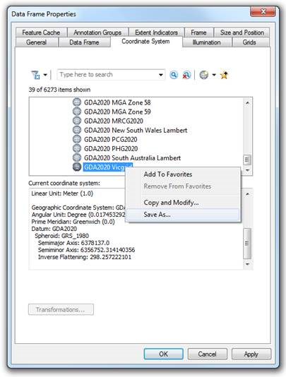
To export the GDA2020 VicGrid definition from the latest ArcMap, go to “Data Frame Properties” and select the “Coordinate System” tab. Browse or search for the definition you would like to export. Right click on the definition and select the “Save As…” option. Save the .prj file to a desired location. The .prj file stores a well-known text (WKT) string definition of the coordinate system. You can view it in any text editor.
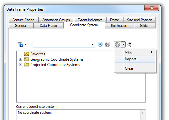
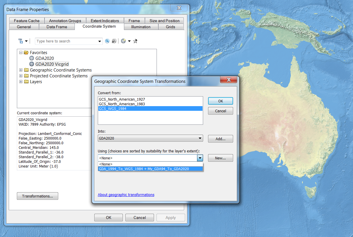
In your older version of ArcMap, return to “Data Frame Properties” window and “Coordinate System” tab. There select the “Add Coordinate System” button, and select the “Import…” option. Browse to the location where you stored the exported .prj file and add it to the system.
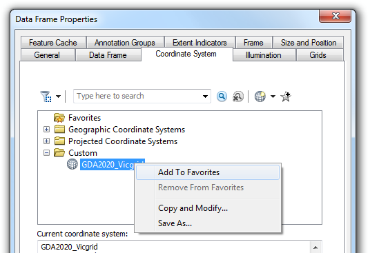
Once you do this, the system will add the definition into your “Favorites” folder and will stay there until you remove it. If this does not happen, you can add the coordinate system to Favorites yourself by right-clicking on the coordinate system and selecting the “Add To Favorites” option.
In our particular example, GDA2020 VicGrid definition also includes the definition of a new geographic coordinate system, GDA2020 (EPSG::7844). Because this geographic coordinate system is not defined in the older version of ArcMap, there is no available transformation that would allow you to transform your data from any coordinate system to GDA2020. Without an available transformation, you will not be able to line up your data properly. Therefore you need to create a custom geographic transformation.
The WKT of GDA2020_Vicgrid is shown below. The GDA2020 definition is embedded and shown in bold text.
PROJCS["GDA2020_Vicgrid",
GEOGCS["GDA2020",
DATUM["GDA2020",
SPHEROID["GRS_1980",6378137.0,298.257222101]],
PRIMEM["Greenwich",0.0],
UNIT["Degree",0.0174532925199433]],
PROJECTION["Lambert_Conformal_Conic"],
PARAMETER["False_Easting",2500000.0],
PARAMETER["False_Northing",2500000.0],
PARAMETER["Central_Meridian",145.0],
PARAMETER["Standard_Parallel_1",-36.0],
PARAMETER["Standard_Parallel_2",-38.0],
PARAMETER["Latitude_Of_Origin",-37.0],
UNIT["Meter",1.0],
AUTHORITY["EPSG",7899]]
EPSG Geodetic Parameter Dataset (epsg-registry.org) is a structured dataset of coordinate reference systems and coordinate transformations. There we can look for transformations that we can use to connect the GDA2020 coordinate reference system with other existing coordinate system in the software. For lists of the available transformations, methods, and areas of use in the latest ArcMap, see this geographic_transformations.pdf file. Let’s use an example of GDA94 to GDA2020 (1) transformation identified with the EPSG:: 8048 code.
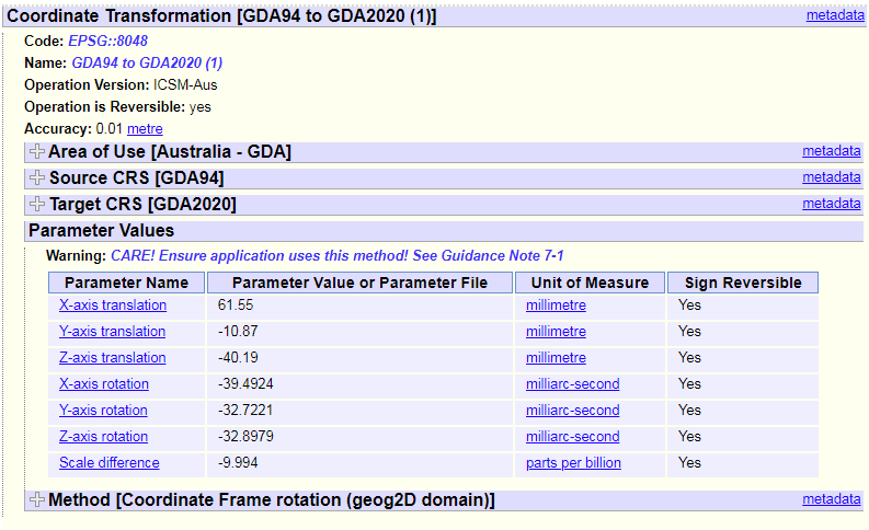 (Source: EPSG)
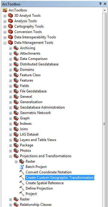
First, we add the geographic coordinate system GDA2020 to the older version of ArcMap using the same workflow introduced above. Next, we browse to a tool for creating a custom geographic transformation. It is available in ArcToolbox, under “Data Management Tools” and “Projections and Transformations.”
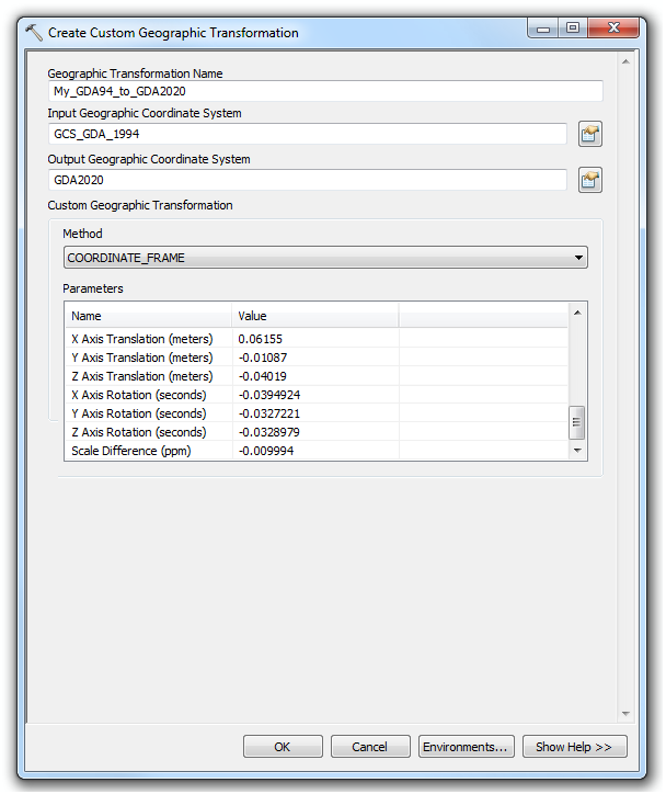
In the tool’s interface, you type the name of your custom geographic transformation. For “Input Geographic Coordinate System” you browse to Geocentric Datum of Australia 1994 (EPSG::4283) already available in your software and you select GDA2020 from your “Favorites” folder for the “Output Geographic Coordinate System.” Next, you specify the method and all required transformation parameters. Note that parameter values differ from the ones provided by EPSG. The reason for this are different units required for the parameters. EPSG-provided parameters are in millimeters, milliarc-seconds and parts per billion, while the “Create Custom Geographic Transformation” tool takes meters, arc-seconds and parts per million (ppm).
Once you add the new coordinate system definitions and create a custom transformation, you will be able to perform the same coordinate operations as you would normally do. Your new custom transformation will be used together with other existing transformations.
This workflow has been tested using ArcGIS 10.1 and 10.6.1. Similar workflow can be performed in ArcGIS Pro. To learn more about coordinate systems and transformations, see the latest DevSummit session Introducing Coordinate Systems and Transformations - YouTube.
Happy projecting! 
You must be a registered user to add a comment. If you've already registered, sign in. Otherwise, register and sign in.