- Home
- :
- All Communities
- :
- Industries
- :
- Conservation
- :
- Conservation Questions
- :
- Find Closest Facilities - Won't Recognize Network ...
- Subscribe to RSS Feed
- Mark Topic as New
- Mark Topic as Read
- Float this Topic for Current User
- Bookmark
- Subscribe
- Mute
- Printer Friendly Page
Find Closest Facilities - Won't Recognize Network File?
- Mark as New
- Bookmark
- Subscribe
- Mute
- Subscribe to RSS Feed
- Permalink
I'm trying to use the Find Closest Facilities tool to determine what the closest barrier to fish passage is compared to some sampling locations. I have a waterflow layer that is a proper geometric network but the tool won't recognize the layer as a network dataset; it shows my geodatabase as empty. Any suggestions?
Solved! Go to Solution.
Accepted Solutions
- Mark as New
- Bookmark
- Subscribe
- Mute
- Subscribe to RSS Feed
- Permalink
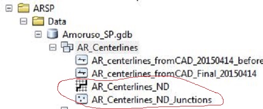
One thing to check is to confirm that it is a Network Analyst Dataset, not a geometric network of other types. Go into ArcCatalog and look to see if you have two files like the ones below. If not, I'm pretty sure you will have to create one (but have not used other Geometric Networks much, so am not 100% sure on this).
Also, here's a past post from GeoNet that draws some distinctions between Geometric Networks and how Network Analyst interacts with them.
network analyst extension vs. geometric networks?
Chris Donohue, GISP
- Mark as New
- Bookmark
- Subscribe
- Mute
- Subscribe to RSS Feed
- Permalink
Just to confirm, you specifically created a new Network Dataset for this? Or are you using a pre-existing Network Dataset?
Chris Donohue, GISP
- Mark as New
- Bookmark
- Subscribe
- Mute
- Subscribe to RSS Feed
- Permalink
It was a pre-existing waterflow network (albeit very new)
- Mark as New
- Bookmark
- Subscribe
- Mute
- Subscribe to RSS Feed
- Permalink
One thing to check is to confirm that it is a Network Analyst Dataset, not a geometric network of other types. Go into ArcCatalog and look to see if you have two files like the ones below. If not, I'm pretty sure you will have to create one (but have not used other Geometric Networks much, so am not 100% sure on this).
Also, here's a past post from GeoNet that draws some distinctions between Geometric Networks and how Network Analyst interacts with them.
network analyst extension vs. geometric networks?
Chris Donohue, GISP
- Mark as New
- Bookmark
- Subscribe
- Mute
- Subscribe to RSS Feed
- Permalink
Also, if you are new to Network Analyst, this tutorial may help in understanding the workflows.
Chris Donohue, GISP
- Mark as New
- Bookmark
- Subscribe
- Mute
- Subscribe to RSS Feed
- Permalink
A geometric network isn't the same thing as a network dataset. Geometric networks are usually used for utilities (power, water, etc.), whereas the network dataset is specifically for roads and used in the Network Analyst extension. Could that be the problem?
- Mark as New
- Bookmark
- Subscribe
- Mute
- Subscribe to RSS Feed
- Permalink
Thanks everyone, I think that's the issue.