- Home
- :
- All Communities
- :
- User Groups
- :
- Conservation GIS
- :
- Documents
- :
- Low Chee Pheng, Malaysia
- Subscribe to RSS Feed
- Mark as New
- Mark as Read
- Bookmark
- Subscribe
- Printer Friendly Page
Low Chee Pheng, Malaysia
Low Chee Pheng, Malaysia
Low Chee Pheng, Wildlife Conservation Society, Malaysia
x2012Scholar x2012Talk xScholar xTalk xWCS xWildlife xMalaysia xAsia xWildlife xTracking xMonitoring xEnforcement xAntipoaching xIndigenous xLandscape  xRemote xForest
Linkedin Profile Biodiversity Society Sarawak Facebook Profile
2018 – present: Instructor, Wildlife Study Design & Data Analysis, Biodiversity Conservation Society Sarawak
2015-2017 Masters Degree, SUNY College of Environmental Science and Forestry
2008-present: Project Coordinator at Wildlife Conservation Society - Malaysia Program
(Photo: Low Chee Peng as a 2012 SCGIS Scholar, courtesy of 2012 Sholar Nico Lois)
2012 Scholar Profile:
*-HISTORY: I joined Wildlife Conservation Society-Malaysia Program (WCS-Malaysia Program) as a researcher in February 2008. Under the Tigers Forever project, I have been actively involved in various components of the Johor Wildlife Conservation Project in Malaysia.
From 2008 to 2012, I was involved in several biological research projects that are essential to measure the effectiveness of conservation interventions in the Endau Rompin Landscape. These include the prey occupancy survey in 2008 and camera trapping survey in 2009 and 2011. I led one of the field teams to carry out field surveys and collect biological data such as presence of animal signs, DNA samples, wildlife photographs etc.
Apart from biological monitoring surveys, I’ve also participated in various enforcement activities (foot patrols, roadblocks, vehicle patrols) together with enforcement staff from the Department of Wildlife and National Park, State Forestry Department of Johor, Royal Malaysia Police and the Johor National Parks Corporation. The joint operations do not only remove threats (snares, nets etc.) from the wildlife habitat, but also raise awareness among the local communities. As a WCS staff, I was responsible for recording all joint enforcement activities, maintaining an enforcement database and producing monthly reports that are sent to the head of respective agencies every month. Through these activities, I’ve learnt management skills, institutional relationships and how to deal with indigenous communities.
While conducting the surveys and maintaining the databases, I realized the importance of GIS in terms of study design, managing survey data and visualization of spatial data. I started using GIS in 2009, shifting from plotting points on maps by hand to importing GPS data into GIS and learned to produce maps for reports and presentations. Together with another colleague who worked in another landscape in Malaysia, I georeferenced and digitized the 1:50,000 topographic maps that covers the Endau Rompin Landscape, collected plantation maps around the landscape, digitized maps that are collected and assisted in mapping of the boundaries of a few villages within the landscape. I’m also responsible of managing all spatial data (vectors, satellite images) in our organization and capacity building for other staffs. In 2011, I acquired 4 ArcGIS licenses for our organization and set up computer systems for GIS needs. I also introduced the free online courses to staff of WCS-Malaysia Program and compiled a list of useful manuals and online resources for them. It is hoped that through increased availability of the software and useful resources, more WCS-Malaysia Program staff will be trained to use GIS in their surveys and analysis.
In 2010, I assisted my colleague in a remote sensing project. The project aims to provide a baseline land-cover map of the Endau Rompin Landscape. I helped to compile necessary data such as concession maps, topographic maps and also led a team to collect ground truth data. In December 2011, I attended a vegetation analysis training at the ENVI offices in Boulder, Colorado. I’m currently coordinating the remote sensing project in the Endau Rompin Landscape.
I’m currently managing the tiger project in the Johor Endau Rompin Landscape, coordinating all activities (camera trapping, corridor monitoring, enforcement activities, remote sensing) under the tiger project. I worked closely with representatives from various agencies to ensure continuous participation of all agencies in the joint enforcement activities and monitoring program. (Photo: Low Chee Peng as a 2017 Masters Student, Friar Lab, SUNY)
What is your work in your local conservation and GIS community? WCS-Malaysia Program has an important commitment to the Johor Wildlife Conservation Project. The aim of JWCP is to ensure the future of wildlife and their habitat at the Endau Rompin Landscape through various components such as capacity building of the enforcement staff in the government departments, law enforcement activities with relevant enforcement agencies and monitoring of tigers and their prey to measure the success. The project is supported by the Royal Family of the State of Johor in Malaysia and the State Cabinet of Johor. The stakeholders of the projects are the Johor National Parks Corporation, Department of Wildlife and National Parks, Forestry Department, Royal Malaysian Police, State Department of Town and Country Planning, State Economic Planning Unit of Johor, Department of Orang Asli Affairs of Johor. The long-term conservation goal is pursued through policy work, law enforcement activities with all relevant enforcement agencies, human-wildlife conflict mitigation, community outreach and monitoring of wildlife. All of this work is done in collaboration with the federal, state and local government agencies and in collaboration with several important local plantation owners. Update meetings are held regularly to discuss and plan for conservation interventions within the landscape.
Other than biological monitoring surveys and enforcement activities, WCS-Malaysia Program also works closely with the local community in terms of human-wildlife conflict and safeguarding their ancestral territories from foreign encroachers. The mitigation projects (e.g. siren fences) help villagers to guard their farms more effectively. More than 15 indigenous people have been hired and trained in wildlife monitoring, natural resource use monitoring and mapping. Most of them have been trained to read maps, use GPS and compass and have helped to collect ground truth data in and around the Endau Rompin Landscape.
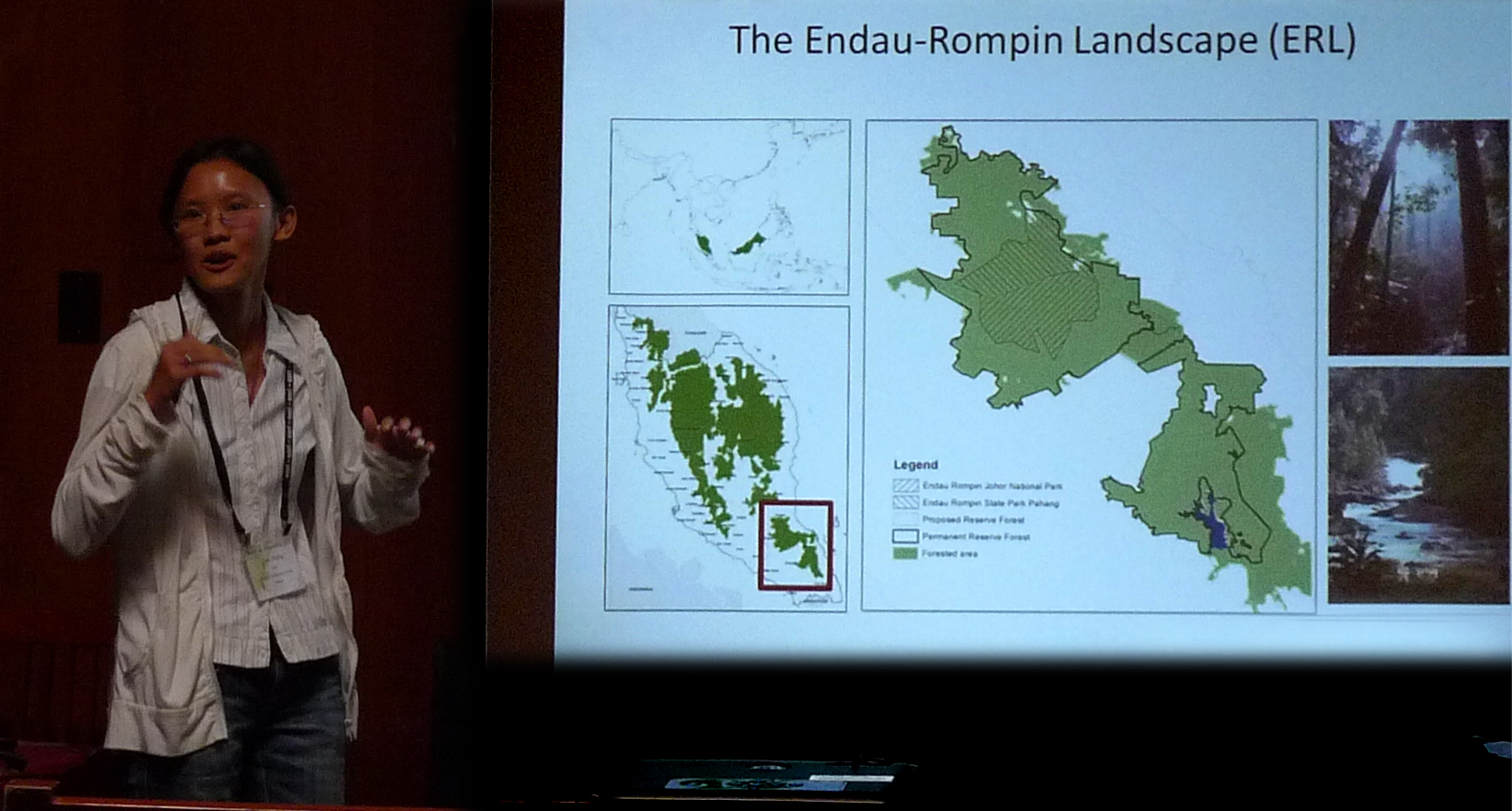
What is the most unique and the most challenging about the conservation/GIS work that you do: Consisting of the Endau Rompin Johor National Park, Endau Rompin State Park of Pahang and permanent reserve forests, the Endau Rompin Landscape is one of the three “source sites” that are believed to hold viable population of tigers and Asian Elephant in Malaysia. The Endau Rompin Landscape is a complex mix of protected areas, palm oil and other plantations, logging concessions, and other categories of state-owned lands. The 3500 sq km landscape is home to indigenous people (the Jakun people) that are distributed in more than 30 villages in and around the landscape. Most of the villagers rely on forest products for their livelihood. For generations, the indigenous people collected forest products such as rattan, wild fruits, fishes, wildmeat etc. from the forest.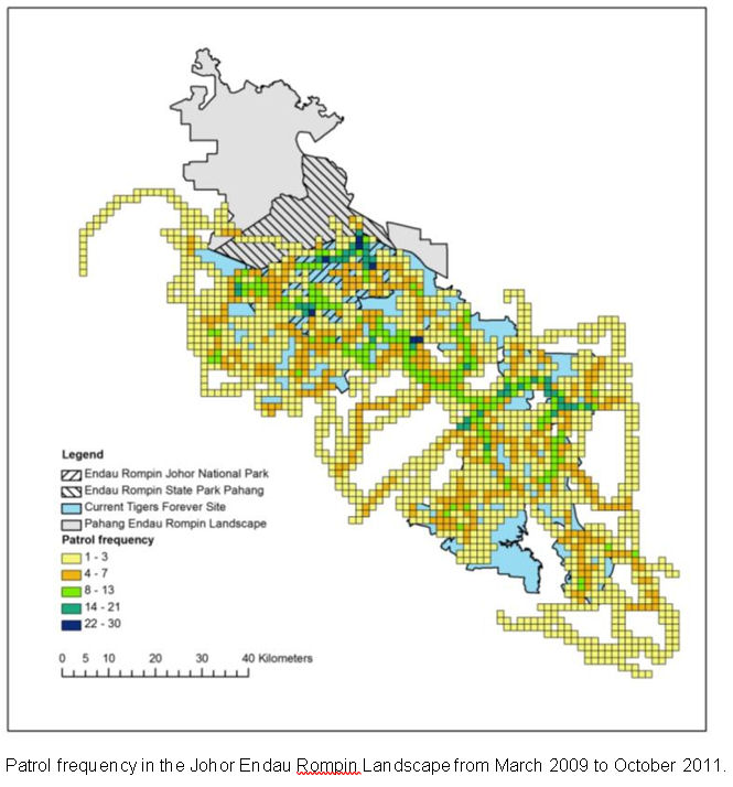
Conversion of forest to oil palm and rubber plantation is one of the major threats in this landscape. Without proper land use planning, conversion to plantations cause fragmentation of wildlife habitat and also affect livelihoods of the indigenous people, through degradation of forest, decrease availability of forest products, increased encroachment by foreigners due to establishment of roads, increased human-wildlife conflict and pollution of water source. The ancestral territories rights of the indigenous communities have been in debate as well. Conflicting claims to land use between various branches of government contributes to this threat by allowing for land uses incompatible with wildlife to be pursued while the confusion is sorted.
It is in this context we are interested in land cover mapping, monitoring of resource use by local communities and encroachers, wildlife use of various habitats in the corridor region of Endau Rompin Landscape.
Working with GIS is certainly challenging in Malaysia. The only available official topographic maps were produced in the 1990’s and date of the release of new map series is unknown. The Department of Wildlife and National Parks, State Forest Department, Department of Town and Country Planning each hold different sets of data, which our organization has little or no access to. Over five years of working closely with these departments, we managed to obtain some data (e.g. paper maps, vector layers) from these departments. To our surprise, the data are either outdated or incorrect and data from different sources conflicts with each other. WCS-Malaysia Program holds some of the most updated data due to the intensive field work and mapping activities that we have conducted over the years. However, we lack the knowledge and skills in managing and to make full use of the information we have now. We need guidance and support in setting up useful database and conducting necessary analysis. The GIS unit in our organization is small; it consists of two self-taught GIS users who spend most of their time coordinating biological monitoring activities, enforcement activities and reviewing Environmental Impact Assessment (EIA) reports. Lacking of time and man power limits our ability to learn and make full use of the GIS tools that we are provided.
2012 Conference Abstract:
Assessing wildlife use in the corridor regions in the Endau Rompin Landscape, Johor, Malaysia
Loss of connectivity through bottlenecks in the Endau Rompin Landscpe is a significant threat. Fragmentation through land conversion of the habitat affects wildlife movement and propagation and will potentially increase rates of human wildlife conflict at villages located in the corridor regions. The State Government of Johor is committed to establish 5000 hectares of latex timber clone plantations (i.e., rubber plantations) and the suggested area for conversion located at the critical corridor region. In this project, we collect data of wildlife use in different habitats in the corridor region (e.g., burnt forest, degraded forest, native forest, grass and bushes, natural swamp, abandoned farms, etc.). Combining the wildlife use data and land cover data that will be completed by June 2012, we hope to be able to establish a map of potential wildlife use in the corridor region, determine important core regions that shall not be converted to plantations, and suggest other locations for such land conversion. The information will also be used to help convince the State Government and Federal Government that land conversion to large-scale monocultures will be detrimental to wildlife using these areas and will reduce connectivity for the Central Forest Spine of Malaysia.
-
 Anonymous User