- Home
- :
- All Communities
- :
- Products
- :
- Attribute Rules
- :
- Attribute Rules Questions
- :
- Re: Calculation Rule- auto populate a point's coor...
- Subscribe to RSS Feed
- Mark Topic as New
- Mark Topic as Read
- Float this Topic for Current User
- Bookmark
- Subscribe
- Mute
- Printer Friendly Page
Calculation Rule- auto populate a point's coordinates into an existing row
- Mark as New
- Bookmark
- Subscribe
- Mute
- Subscribe to RSS Feed
- Permalink
Hi,
I was wondering if it's possible to auto populate the coordinates of a created point feature into an existing row rather than a new row.
Thanks!
Solved! Go to Solution.
Accepted Solutions
- Mark as New
- Bookmark
- Subscribe
- Mute
- Subscribe to RSS Feed
- Permalink
Something like this could do what you want:
- create a point feature class, add GlobalID
- create a field in that fc that will work as a foreign key to the table you wish to edit
- edit and add this attribute rule
// Calculation Attribute Rule on your point FC
// Field: empty
// Triggers: Insert
// Exclude from application evaluation

// get the rows that will be updated
var key = $feature.KeyField
var table = FeatureSetByName($datastore, "Database.Dataowner.TableYouWantToEdit", ["GlobalID", "KeyField"], false)
var rows = Filter(table, "KeyField = @key")

// create and fill the update array
var lat_long_attributes = {"LAT": Geometry($feature).y, "LONG": Geometry($feature).x}
var updates = []
for(var row in rows) {
    Push(updates, {"globalID": row.GlobalID, "attributes": lat_long_attributes}
}

// tell ArcGIS to edit the table
return {
    "edit" [{
        "className": "Database.Dataowner.TableYouWantToEdit",
        "updates": updates
    }]
}
The workflow for this would be
- copy the key of the feature you want to edit
- create point feature --> paste key into the feature template, create the point in the correct location
- the attribute rule will trigger and write the coordinates of the new point into the lat/long fields of the row(s) you specified with the key
Have a great day!
Johannes
- Mark as New
- Bookmark
- Subscribe
- Mute
- Subscribe to RSS Feed
- Permalink
So you want to do something like this?
- Click on Create Features, choose the point template
- Click into the map
- but instead of creating a new feature, the coordinates of an existing point are updated
This could be kinda possible (you'd end up with a feature without geometry, so you wouldn't see it on the map). But, questions:
- What's your use case?
- Why not use the edit tools to edit the existing point?
- How would you decide which existing point to edit?
- Coordinates as in numeric fields in the table or as in the actual point geometry?
Have a great day!
Johannes
- Mark as New
- Bookmark
- Subscribe
- Mute
- Subscribe to RSS Feed
- Permalink
Thanks for your reply,
So you want to do something like this?
- Click on Create Features, choose the point template
- Click into the map
but instead of creating a new feature, the coordinates of an existing point are updated
I want to add a new point feature that populates the coordinates into empty lat/long fields in an existing row in my table.
I want an editor to add coordinates to places that have wrong attribute info so the data can be fixed downstream using the updated coordinates. I want as little manual editing done as possible so I thought this could be a good solution (no copy/pasting correct coordinates into lat/long fields). We don’t edit existing data, just update new corresponding fields.
Hope I answered all your questions!
- Mark as New
- Bookmark
- Subscribe
- Mute
- Subscribe to RSS Feed
- Permalink
Something like this could do what you want:
- create a point feature class, add GlobalID
- create a field in that fc that will work as a foreign key to the table you wish to edit
- edit and add this attribute rule
// Calculation Attribute Rule on your point FC
// Field: empty
// Triggers: Insert
// Exclude from application evaluation

// get the rows that will be updated
var key = $feature.KeyField
var table = FeatureSetByName($datastore, "Database.Dataowner.TableYouWantToEdit", ["GlobalID", "KeyField"], false)
var rows = Filter(table, "KeyField = @key")

// create and fill the update array
var lat_long_attributes = {"LAT": Geometry($feature).y, "LONG": Geometry($feature).x}
var updates = []
for(var row in rows) {
    Push(updates, {"globalID": row.GlobalID, "attributes": lat_long_attributes}
}

// tell ArcGIS to edit the table
return {
    "edit" [{
        "className": "Database.Dataowner.TableYouWantToEdit",
        "updates": updates
    }]
}
The workflow for this would be
- copy the key of the feature you want to edit
- create point feature --> paste key into the feature template, create the point in the correct location
- the attribute rule will trigger and write the coordinates of the new point into the lat/long fields of the row(s) you specified with the key
Have a great day!
Johannes
- Mark as New
- Bookmark
- Subscribe
- Mute
- Subscribe to RSS Feed
- Permalink
Thanks for your help, I really appreciate it!
- Mark as New
- Bookmark
- Subscribe
- Mute
- Subscribe to RSS Feed
- Permalink
Thanks again!
- Mark as New
- Bookmark
- Subscribe
- Mute
- Subscribe to RSS Feed
- Permalink
Are you sure that you're creating it on the right feature class? This behavior sounds like you create the rule on the class you want to update.
Have a great day!
Johannes
- Mark as New
- Bookmark
- Subscribe
- Mute
- Subscribe to RSS Feed
- Permalink
Thanks again!
- Mark as New
- Bookmark
- Subscribe
- Mute
- Subscribe to RSS Feed
- Permalink
Yeah, as I thought.
You're adding the rule to the feature class you want to update. That means that you create a point, and then the rule triggers and edits a point in the same class.
The rule is meant to be created on a different point feature class that you use to edit the "real" feature class.
Have a great day!
Johannes
- Mark as New
- Bookmark
- Subscribe
- Mute
- Subscribe to RSS Feed
- Permalink
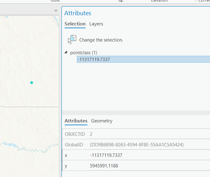
Here is a filegdb example which a calculation rule updates the X and Y fields with the point's geometry coordinates on insert and update. We assign the field as empty so we can update multiple fields in one shot. The rule is simple
var g = Geometry($feature);
var x = g.x;
var y = g.y;
return {
	"result": {
		"attributes": {
			"x": x,
			"y": y
		}
	}
}
the rule