Turn on suggestions
Auto-suggest helps you quickly narrow down your search results by suggesting possible matches as you type.
Cancel
- Home
- :
- All Communities
- :
- Products
- :
- ArcPad (Retired)
- :
- ArcPad Questions
- :
- ???GPS position window???: data, skyplot, campus, ...
Options
- Subscribe to RSS Feed
- Mark Topic as New
- Mark Topic as Read
- Float this Topic for Current User
- Bookmark
- Subscribe
- Mute
- Printer Friendly Page
???GPS position window???: data, skyplot, campus, qulity and debug,
Subscribe
01-12-2014
11:38 AM
- Mark as New
- Bookmark
- Subscribe
- Mute
- Subscribe to RSS Feed
- Permalink
???GPS position window???: data, skyplot, campus, qulity and debug,
I couldn???t precisely figure out the meaning of the information provided in the ???GPS position window???
Data
[ATTACH=CONFIG]30428[/ATTACH]
Skyplot
[ATTACH=CONFIG]30429[/ATTACH]
Campus
[ATTACH=CONFIG]30430[/ATTACH]
Quality
[ATTACH=CONFIG]30431[/ATTACH]
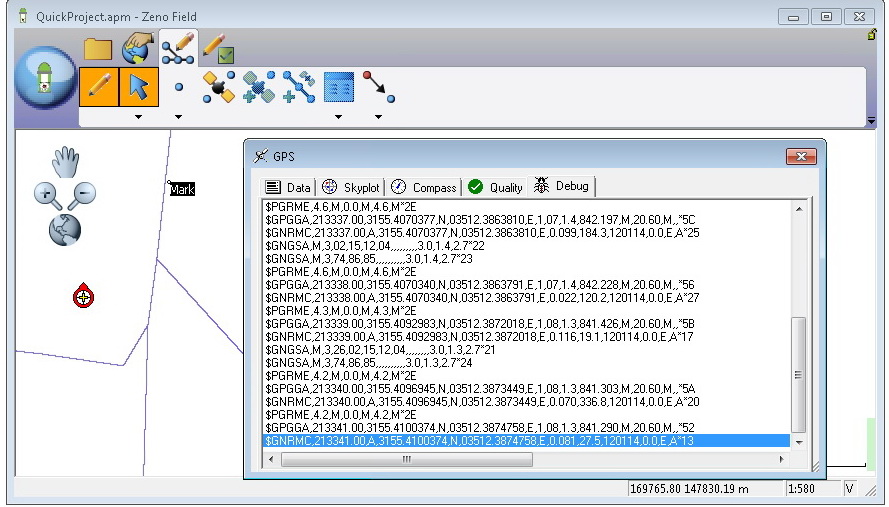
Debug
[ATTACH=CONFIG]30432[/ATTACH]
Thank you
Best
Jamal
I couldn???t precisely figure out the meaning of the information provided in the ???GPS position window???
Data
[ATTACH=CONFIG]30428[/ATTACH]
Skyplot
[ATTACH=CONFIG]30429[/ATTACH]
Campus
[ATTACH=CONFIG]30430[/ATTACH]
Quality
[ATTACH=CONFIG]30431[/ATTACH]
Debug
[ATTACH=CONFIG]30432[/ATTACH]
Thank you
Best
Jamal
----------------------------------------
Jamal Numan
Geomolg Geoportal for Spatial Information
Ramallah, West Bank, Palestine
Jamal Numan
Geomolg Geoportal for Spatial Information
Ramallah, West Bank, Palestine
Solved! Go to Solution.
1 Solution
Accepted Solutions
by
Anonymous User
Not applicable
01-13-2014
06:25 PM
- Mark as New
- Bookmark
- Subscribe
- Mute
- Subscribe to RSS Feed
- Permalink
Original User: HannahFerrier
Hi Jamal,
There is an abundance of information on the GPS Position Window!! (most of it can be found here)
The Data Tab displays the following information:
Position Information
- GPS Location: the coordinates for the current GPS position
- Elevation: vertical position (altitude or depth)
- PDOP (positional dilution of precision): the accuracy of the current position (0-99)
- GPS Mode:
NOFIX = not recieving a position
2D = 3 satellites used to calculate x and y coordinates
3D = at least 4 satellites used to calculate x, y and z coordinates
Navigation Information (used when navigating to a location)
- SOG (speed over ground): the speed of the movement of the GPS position
- COG (course over ground): the direction of the movement of the GPS position
- DST (distance): the distance from the GPS to selected location
- BRG (bearing): the direction from the GPS to selected location
The GPS Skyplot show all of the GPS satellites that are visible to the receiver. Each satellite has an identification number. GPS satellites have vertical wings, GLONASS satellites have horizontal wings and SBAS satellites have no wings. Grey satellites are unavailable, colored satellites are available but are not used for calculating position. Satellites used for calculating position are colored and outlined in black.The Signal Strength Bar Chart shows the signal strength of all available satellites. Satellites used for calculating position are marked using a black asterisk.
The Compass is used when navigating to a location. This is the same navigation information as the Data Tab, but with a pictorial representation of the compass. COG is marked using the black arrow and BRG is marked using the red marker.
The Quality tab gives detailed GPS signal quality information. Some extra measures are:
- HDOP, VDOP and TDOP: These are the respective horizontal, vertical and time componants that make up overall PDOP
- EPE (estimated position error): pseudorange of GPS position consisting of HPE and VPE
- Satellites in solution/view: fraction of satellites used to calculate position from the overall available number of satellites
- DAGE (differential data age): the age of the information used for differential GPS
The GPS Debug Window lets you read the raw input from the GPS. This is especially helpful when troubleshooting GPS connections.
Hope this was helpful,
Hannah 🙂
2 Replies
by
Anonymous User
Not applicable
01-13-2014
06:25 PM
- Mark as New
- Bookmark
- Subscribe
- Mute
- Subscribe to RSS Feed
- Permalink
Original User: HannahFerrier
Hi Jamal,
There is an abundance of information on the GPS Position Window!! (most of it can be found here)
The Data Tab displays the following information:
Position Information
- GPS Location: the coordinates for the current GPS position
- Elevation: vertical position (altitude or depth)
- PDOP (positional dilution of precision): the accuracy of the current position (0-99)
- GPS Mode:
NOFIX = not recieving a position
2D = 3 satellites used to calculate x and y coordinates
3D = at least 4 satellites used to calculate x, y and z coordinates
Navigation Information (used when navigating to a location)
- SOG (speed over ground): the speed of the movement of the GPS position
- COG (course over ground): the direction of the movement of the GPS position
- DST (distance): the distance from the GPS to selected location
- BRG (bearing): the direction from the GPS to selected location
The GPS Skyplot show all of the GPS satellites that are visible to the receiver. Each satellite has an identification number. GPS satellites have vertical wings, GLONASS satellites have horizontal wings and SBAS satellites have no wings. Grey satellites are unavailable, colored satellites are available but are not used for calculating position. Satellites used for calculating position are colored and outlined in black.The Signal Strength Bar Chart shows the signal strength of all available satellites. Satellites used for calculating position are marked using a black asterisk.
The Compass is used when navigating to a location. This is the same navigation information as the Data Tab, but with a pictorial representation of the compass. COG is marked using the black arrow and BRG is marked using the red marker.
The Quality tab gives detailed GPS signal quality information. Some extra measures are:
- HDOP, VDOP and TDOP: These are the respective horizontal, vertical and time componants that make up overall PDOP
- EPE (estimated position error): pseudorange of GPS position consisting of HPE and VPE
- Satellites in solution/view: fraction of satellites used to calculate position from the overall available number of satellites
- DAGE (differential data age): the age of the information used for differential GPS
The GPS Debug Window lets you read the raw input from the GPS. This is especially helpful when troubleshooting GPS connections.
Hope this was helpful,
Hannah 🙂
Hi Jamal,
There is an abundance of information on the GPS Position Window!! (most of it can be found here)
The Data Tab displays the following information:
Position Information
- GPS Location: the coordinates for the current GPS position
- Elevation: vertical position (altitude or depth)
- PDOP (positional dilution of precision): the accuracy of the current position (0-99)
- GPS Mode:
NOFIX = not recieving a position
2D = 3 satellites used to calculate x and y coordinates
3D = at least 4 satellites used to calculate x, y and z coordinates
Navigation Information (used when navigating to a location)
- SOG (speed over ground): the speed of the movement of the GPS position
- COG (course over ground): the direction of the movement of the GPS position
- DST (distance): the distance from the GPS to selected location
- BRG (bearing): the direction from the GPS to selected location
The GPS Skyplot show all of the GPS satellites that are visible to the receiver. Each satellite has an identification number. GPS satellites have vertical wings, GLONASS satellites have horizontal wings and SBAS satellites have no wings. Grey satellites are unavailable, colored satellites are available but are not used for calculating position. Satellites used for calculating position are colored and outlined in black.The Signal Strength Bar Chart shows the signal strength of all available satellites. Satellites used for calculating position are marked using a black asterisk.
The Compass is used when navigating to a location. This is the same navigation information as the Data Tab, but with a pictorial representation of the compass. COG is marked using the black arrow and BRG is marked using the red marker.
The Quality tab gives detailed GPS signal quality information. Some extra measures are:
- HDOP, VDOP and TDOP: These are the respective horizontal, vertical and time componants that make up overall PDOP
- EPE (estimated position error): pseudorange of GPS position consisting of HPE and VPE
- Satellites in solution/view: fraction of satellites used to calculate position from the overall available number of satellites
- DAGE (differential data age): the age of the information used for differential GPS
The GPS Debug Window lets you read the raw input from the GPS. This is especially helpful when troubleshooting GPS connections.
Hope this was helpful,
Hannah 🙂
01-16-2014
09:55 AM
- Mark as New
- Bookmark
- Subscribe
- Mute
- Subscribe to RSS Feed
- Permalink
Hi Jamal,
There is an abundance of information on the GPS Position Window!! (most of it can be found here)
The Data Tab displays the following information:
Position Information
- GPS Location: the coordinates for the current GPS position
- Elevation: vertical position (altitude or depth)
- PDOP (positional dilution of precision): the accuracy of the current position (0-99)
- GPS Mode:
NOFIX = not recieving a position
2D = 3 satellites used to calculate x and y coordinates
3D = at least 4 satellites used to calculate x, y and z coordinates
Navigation Information (used when navigating to a location)
- SOG (speed over ground): the speed of the movement of the GPS position
- COG (course over ground): the direction of the movement of the GPS position
- DST (distance): the distance from the GPS to selected location
- BRG (bearing): the direction from the GPS to selected location
The GPS Skyplot show all of the GPS satellites that are visible to the receiver. Each satellite has an identification number. GPS satellites have vertical wings, GLONASS satellites have horizontal wings and SBAS satellites have no wings. Grey satellites are unavailable, colored satellites are available but are not used for calculating position. Satellites used for calculating position are colored and outlined in black.The Signal Strength Bar Chart shows the signal strength of all available satellites. Satellites used for calculating position are marked using a black asterisk.
The Compass is used when navigating to a location. This is the same navigation information as the Data Tab, but with a pictorial representation of the compass. COG is marked using the black arrow and BRG is marked using the red marker.
The Quality tab gives detailed GPS signal quality information. Some extra measures are:
- HDOP, VDOP and TDOP: These are the respective horizontal, vertical and time componants that make up overall PDOP
- EPE (estimated position error): pseudorange of GPS position consisting of HPE and VPE
- Satellites in solution/view: fraction of satellites used to calculate position from the overall available number of satellites
- DAGE (differential data age): the age of the information used for differential GPS
The GPS Debug Window lets you read the raw input from the GPS. This is especially helpful when troubleshooting GPS connections.
Hope this was helpful,
Hannah 🙂
Thank you very much Hannah for the very valuable elaboration. Now, it is much more clear.
Appreciated
Jamal
----------------------------------------
Jamal Numan
Geomolg Geoportal for Spatial Information
Ramallah, West Bank, Palestine
Jamal Numan
Geomolg Geoportal for Spatial Information
Ramallah, West Bank, Palestine