Turn on suggestions
Auto-suggest helps you quickly narrow down your search results by suggesting possible matches as you type.
Cancel
- Home
- :
- All Communities
- :
- Products
- :
- ArcPad
- :
- ArcPad Questions
- :
- Re: Accuracy issue in capturing XYZ points with Ar...
Options
- Subscribe to RSS Feed
- Mark Topic as New
- Mark Topic as Read
- Float this Topic for Current User
- Bookmark
- Subscribe
- Mute
- Printer Friendly Page
Accuracy issue in capturing XYZ points with ArcPad installed in Leica CS25,
Subscribe
3961
14
11-25-2013 08:38 AM
11-25-2013
08:38 AM
- Mark as New
- Bookmark
- Subscribe
- Mute
- Subscribe to RSS Feed
- Permalink
- Report Inappropriate Content
Accuracy issue in capturing XYZ points with ArcPad installed in Leica CS25,
I tried to capture the XYZ of a known point with our GPS device (Leica CS25 + GG03 Antenna) but the sounds that the captured point is not accurate knowing that this point is real-time differentially corrected. The error is X is about 6 meters while the error in Y is about 8 meters.
The coordinate system is set to be ???D-Palestine-1923???
What might be the issue here?
Thank you
Best
Jamal
----------------------------------------
Jamal Numan
Geomolg Geoportal for Spatial Information
Ramallah, West Bank, Palestine
Jamal Numan
Geomolg Geoportal for Spatial Information
Ramallah, West Bank, Palestine
14 Replies
11-28-2013
10:47 AM
- Mark as New
- Bookmark
- Subscribe
- Mute
- Subscribe to RSS Feed
- Permalink
- Report Inappropriate Content
Jamal,
If you are to be using Palestine_1923_Palestine_Grid and you know for certain that your control points are in the same coordinate system, then there is no need to modify anything related to the parameters of your projection files.
I said Zeno Connect allows you to setup your coordinate system as well as an associated transformation based on your corrections. Is your Leica representative also the owner of the real-time network you are receiving RTK corrections? They should be able to tell you what coordinate system the real-time network is referencing regardless of which software you are using for field collection.
Hi Brett,
1. In the �??zeno connect�?�, there are 4 transformations (attached) for our coordinate system (Palestine_1923_Palestine_Grid)
�?� Palestine 1923 (1)
�?� Palestine 1923 (2)
�?� Palestine 1923 1X
�?� Palestine 1923 2X
What might be the appropriate one? Till now, I didn�??t get an answer from the company
[ATTACH=CONFIG]29448[/ATTACH],
2. Sounds that there is no way to choose the coordinate system\transformation directly from the ArcPad the same way we do it in the �??zeno connect�?�. Is this an issue?
[ATTACH=CONFIG]29449[/ATTACH]
3. Is the mountpoint also relevant to the accuracy?
[ATTACH=CONFIG]29450[/ATTACH]
----------------------------------------
Jamal Numan
Geomolg Geoportal for Spatial Information
Ramallah, West Bank, Palestine
Jamal Numan
Geomolg Geoportal for Spatial Information
Ramallah, West Bank, Palestine
11-30-2013
06:32 AM
- Mark as New
- Bookmark
- Subscribe
- Mute
- Subscribe to RSS Feed
- Permalink
- Report Inappropriate Content
Jamal,
You are likely going to have to test each transformation against known control to better gauge which is the correction transformation. I am not familiar with your coordinate system, real-time network, etc. so I cannot help there.
If you are using Zeno Office/Zeno Office on ArcGIS and Zeno Field, your transformations are setup in your Survey Dataset/Survey Project. the coordinate system tab you highlighted in Zeno Field is only for the geoid model, which is applied in the Survey Project along with a transformation, if needed. If you are using Zeno Connect with Esri ArcPad, then the transformation is handheld in Zeno Connect. Note that ArcPad and Zeno Field are similar applications, but Leica's Zeno Field enables advantages to high-accuracy field data collection.
Mountpoints are defined by the real-time network provider. Each mountpoint is a unique product and you must select one compatible with your GNSS hardware. RTCM is utilized by most, if not all, GNSS equipment, including Leica. If you are receiving a phase-fixed solution and roughly 1cm accuracy, your parameters are set correctly for your real-time network. From there, it is based on the coordinate systems and transformations being applied.
12-01-2013
09:58 AM
- Mark as New
- Bookmark
- Subscribe
- Mute
- Subscribe to RSS Feed
- Permalink
- Report Inappropriate Content
Jamal,
You are likely going to have to test each transformation against known control to better gauge which is the correction transformation. I am not familiar with your coordinate system, real-time network, etc. so I cannot help there.
If you are using Zeno Office/Zeno Office on ArcGIS and Zeno Field, your transformations are setup in your Survey Dataset/Survey Project. the coordinate system tab you highlighted in Zeno Field is only for the geoid model, which is applied in the Survey Project along with a transformation, if needed. If you are using Zeno Connect with Esri ArcPad, then the transformation is handheld in Zeno Connect. Note that ArcPad and Zeno Field are similar applications, but Leica's Zeno Field enables advantages to high-accuracy field data collection.
Mountpoints are defined by the real-time network provider. Each mountpoint is a unique product and you must select one compatible with your GNSS hardware. RTCM is utilized by most, if not all, GNSS equipment, including Leica. If you are receiving a phase-fixed solution and roughly 1cm accuracy, your parameters are set correctly for your real-time network. From there, it is based on the coordinate systems and transformations being applied.
Thank you Brett for the very useful answer.
Please, find below the answer I got from the company. What do you think?
------------------------------
1. If you haven't use the "zeno out" process, the transformation doesn't update with the shape files in zeno filed.
When you just copy-past shape file to the tablet you should generate the transformation file, using the "datum transformation configuration tool"
Here you have a video, explaining how to do it:
https://www.sugarsync.com/pf/D0459014_62440860_854568
You can also generate a one-time project in zeno office, export it to the tablet using "zeno out". And the transformation will update to the all future projects.
2. In zeno connect The transformation can be editing according to your own preference. I've attached picture with the values that I have. Please check before using them.
But, if you are using "Carlson" software, all the coordinate system Is already pre-define in it. So you don't need to use the zeno connect coordinate system settings.
3. The zeno field using an old version of the NMEA module, so there is still no coordinate systems configuration embedded in it. Zeno connect using the new version so the configuration is there.
----------------------------------------
Jamal Numan
Geomolg Geoportal for Spatial Information
Ramallah, West Bank, Palestine
Jamal Numan
Geomolg Geoportal for Spatial Information
Ramallah, West Bank, Palestine
12-03-2013
10:28 AM
- Mark as New
- Bookmark
- Subscribe
- Mute
- Subscribe to RSS Feed
- Permalink
- Report Inappropriate Content
If I am understanding the response correctly, this looks accurate to me.
The most efficient way to take data to the field when using Zeno Office/Zeno Office on ArcGIS and Zeno Field is to utilize the EasyOut/In process. From your geodatabase the process creates an EasyOut folder with the necessary files files to be utilized in Zeno Field on your CS25 unit. Once field collection is completed you start an editing session and EasyIn the field data.
If using Zeno Connect and ArcPad, you will utilize the ArcPad Data Manager, which is a similar process to the EasyOut/In process, however, the Survey Dataset and Survey Project allow for transformations, CSCS files and geoid models.
12-03-2013
12:17 PM
- Mark as New
- Bookmark
- Subscribe
- Mute
- Subscribe to RSS Feed
- Permalink
- Report Inappropriate Content
If I am understanding the response correctly, this looks accurate to me.
The most efficient way to take data to the field when using Zeno Office/Zeno Office on ArcGIS and Zeno Field is to utilize the EasyOut/In process. From your geodatabase the process creates an EasyOut folder with the necessary files files to be utilized in Zeno Field on your CS25 unit. Once field collection is completed you start an editing session and EasyIn the field data.
If using Zeno Connect and ArcPad, you will utilize the ArcPad Data Manager, which is a similar process to the EasyOut/In process, however, the Survey Dataset and Survey Project allow for transformations, CSCS files and geoid models.
Thanks Brett,
For me, I�??m using ArcMap\ArcPad\Zeno connect,
1. I do use the �??ArcPad data manager�?� to include all the layers in one apm file
2. I open the apm file from the ArcPad and then to capture points
This doesn�??t produce accurate XYZ capturing
The second feedback I got from the company is to:
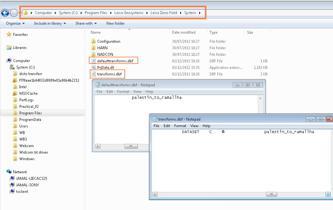
1. replace the two files (DefaultTransforms.dbf and transforms.dbf) available on the C:\Program Files\Leica Geosystems\Leica Zeno Field\System with the ones provided by the company
2. add the shape file to the Zeno field and then to capture points
[ATTACH=CONFIG]29543[/ATTACH], [ATTACH=CONFIG]29544[/ATTACH]
This doesn�??t produce accurate XYZ capturing neither
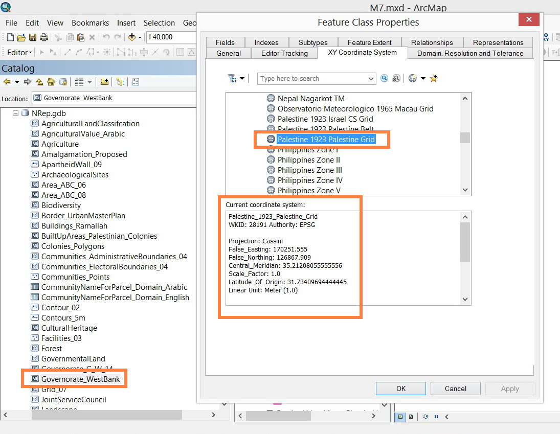
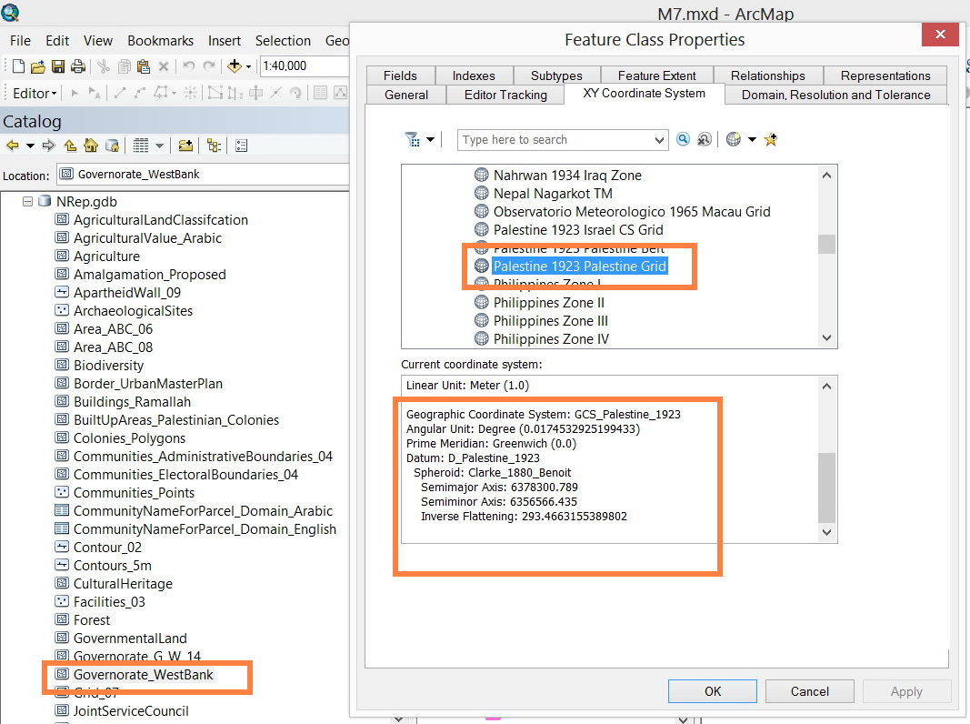
Then I�??m required to compare the coordinate system of the layer on the ArcMap with that one on the ArcPad and to check if they are the same!
[ATTACH=CONFIG]29545[/ATTACH], [ATTACH=CONFIG]29546[/ATTACH], [ATTACH=CONFIG]29547[/ATTACH]
At the end, the captured XYZ are not accurate. Still waiting further feedback from the company
----------------------------------------
Jamal Numan
Geomolg Geoportal for Spatial Information
Ramallah, West Bank, Palestine
Jamal Numan
Geomolg Geoportal for Spatial Information
Ramallah, West Bank, Palestine
- « Previous
-
- 1
- 2
- Next »
- « Previous
-
- 1
- 2
- Next »