- Home
- :
- All Communities
- :
- Developers
- :
- ArcObjects SDK
- :
- ArcObjects SDK Questions
- :
- Problem adding field to existing shapefile
- Subscribe to RSS Feed
- Mark Topic as New
- Mark Topic as Read
- Float this Topic for Current User
- Bookmark
- Subscribe
- Mute
- Printer Friendly Page
- Mark as New
- Bookmark
- Subscribe
- Mute
- Subscribe to RSS Feed
- Permalink
hello All
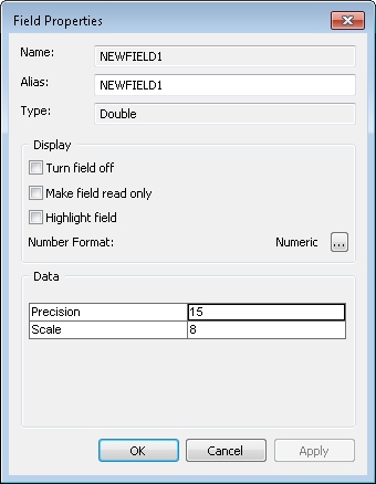
I have a VB.NET set of tools and part of it which used to work does not seem to work any more as it used to. The part of the script which is not working properly anymore is when adding a field to an existing shapefile. Although I am setting the precision and scale properties of the ifieldedit interface the resultant field displays in ArcMap as having precision and scale values of 0. The type of the field is esriFieldTypeDouble.
What am I missing here?
regards
shawn
Solved! Go to Solution.
Accepted Solutions
- Mark as New
- Bookmark
- Subscribe
- Mute
- Subscribe to RSS Feed
- Permalink
aha
a bit more hunting found the answer. It's a known bug in 10.4 and 10.4.1
BUG-000099718 -> Numeric values stored in DOUBLE and FLOAT fields are corrupted in shapefiles created in ArcGIS for Desktop 10.4 and 10.4.1. Shapefiles that are created at earlier versions perform correctly when opened in ArcGIS for Desktop 10.4.
cheers
shawn
- Mark as New
- Bookmark
- Subscribe
- Mute
- Subscribe to RSS Feed
- Permalink
Although I have no idea what you are doing in VB.NET...
Are you sure that the shapefile (in reality dbf, dbase) can support precision and scale.
- Mark as New
- Bookmark
- Subscribe
- Mute
- Subscribe to RSS Feed
- Permalink
hello Neil
I am creating some data as part of a process in VB.NET and then I want to add that data to an existing shapefile. I didn't think that the actual particulars of what I was doing was relevant to the underlying question that I had and didn't want to obscure my question.
Thanks for the link, although my reading of it is that it can support precision and scale. This also supports my recollection that my script used to add the field with precision and scale values in the past.
Although we don't have earlier versions of ArcGIS installed here at work we do have ArcView 3.3 still working. So I tested in that the addition of a field with precision and scale values to a shapefile. The shapefile when opened in ArcGIS 10.4.1 reports the precision and scale correctly.

When I tried to add a new field directly through the table interface in ArcMap it did not create the field with precision and scale values.
regards
shawn
- Mark as New
- Bookmark
- Subscribe
- Mute
- Subscribe to RSS Feed
- Permalink
aha
a bit more hunting found the answer. It's a known bug in 10.4 and 10.4.1
BUG-000099718 -> Numeric values stored in DOUBLE and FLOAT fields are corrupted in shapefiles created in ArcGIS for Desktop 10.4 and 10.4.1. Shapefiles that are created at earlier versions perform correctly when opened in ArcGIS for Desktop 10.4.
cheers
shawn