Turn on suggestions
Auto-suggest helps you quickly narrow down your search results by suggesting possible matches as you type.
Cancel
- Home
- :
- All Communities
- :
- Developers
- :
- ArcObjects SDK (Retired)
- :
- ArcObjects SDK Questions
- :
- [C#] How to create Line of Sight?
Options
- Subscribe to RSS Feed
- Mark Topic as New
- Mark Topic as Read
- Float this Topic for Current User
- Bookmark
- Subscribe
- Mute
- Printer Friendly Page
03-27-2013
03:42 AM
- Mark as New
- Bookmark
- Subscribe
- Mute
- Subscribe to RSS Feed
- Permalink
Hello
I'm able to load a DTED Level 0 file into a RasterDataset, color it and create a IRasterLayer from it to add into axMapControl. Here is my working code:
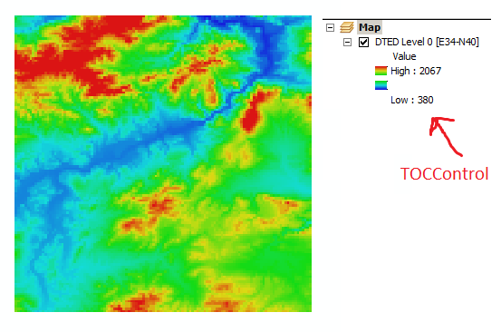
The result is this screenshot of axMapControl:[ATTACH=CONFIG]22980[/ATTACH]
Now, I want to create Line of Sight; between observer and a point. How can I do that? I have no idea unfortunately.
Thanks
I'm able to load a DTED Level 0 file into a RasterDataset, color it and create a IRasterLayer from it to add into axMapControl. Here is my working code:
IWorkspaceFactory wsf = new RasterWorkspaceFactoryClass(); IRasterWorkspace rasterWS = (IRasterWorkspace)wsf.OpenFromFile(@"C:\Users\ABC\Desktop\DTED_E30N40\dted\e034", 0); rasterDS = rasterWS.OpenRasterDataset("n40.dt0"); IRasterBandCollection pRasterBandCollection = (IRasterBandCollection)rasterDS; IEnumRasterBand pEnumRasterBand = pRasterBandCollection.Bands; IRasterBand pRasterBand = pEnumRasterBand.Next(); pRasterBand.ComputeStatsAndHist(); IRasterStatistics pRasterStatistics = pRasterBand.Statistics; IRgbColor pFromColor = new RgbColorClass(); pFromColor.Red = 20; pFromColor.Green = 20; pFromColor.Blue = 220; IRgbColor pToColor = new RgbColorClass(); pToColor.Red = 220; pToColor.Green = 20; pToColor.Blue = 20; IAlgorithmicColorRamp pAlgorithmicColorRamp = new AlgorithmicColorRampClass(); pAlgorithmicColorRamp.FromColor = pFromColor; pAlgorithmicColorRamp.ToColor = pToColor; pAlgorithmicColorRamp.Algorithm = esriColorRampAlgorithm.esriHSVAlgorithm; pAlgorithmicColorRamp.Size = 255; bool bOK; pAlgorithmicColorRamp.CreateRamp(out bOK); IRasterStretchColorRampRenderer pRasterStretchColorRampRenderer = new RasterStretchColorRampRendererClass(); pRasterStretchColorRampRenderer.BandIndex = 0; pRasterStretchColorRampRenderer.LabelHigh = pRasterStatistics.Maximum.ToString(); pRasterStretchColorRampRenderer.LabelLow = pRasterStatistics.Minimum.ToString(); pRasterStretchColorRampRenderer.ColorRamp = pAlgorithmicColorRamp; IRasterLayer rasterLayer = new RasterLayer(); rasterLayer.CreateFromDataset(rasterDS); rasterLayer.Name = "DTED Level 0 [E34-N40]"; rasterLayer.Renderer = (IRasterRenderer)pRasterStretchColorRampRenderer; axMapControl1.AddLayer(rasterLayer);The result is this screenshot of axMapControl:[ATTACH=CONFIG]22980[/ATTACH]
Now, I want to create Line of Sight; between observer and a point. How can I do that? I have no idea unfortunately.
Thanks
Solved! Go to Solution.
11 Replies
03-27-2013
09:53 AM
- Mark as New
- Bookmark
- Subscribe
- Mute
- Subscribe to RSS Feed
- Permalink
Thank you very much Neil; for mentioning ISurface and thank you ScJpike; for your helpful link 🙂
Now, I'm able to get linear line of sight of two points, as you see: [ATTACH=CONFIG]23004[/ATTACH]
Well, is there any way to give observer's Z (elevation) and get line of sight of that point with given Z (not the elevation in DTED)? Imagine that I want to get LLOS of a helicopter that abviously it's elevation is greater that DTED's elevation of that point.
Or it's only possible with DTED elevations? Any idea?
Thank you very much guys
Sincerely
Glad we could help.
You should probably post a new thread for the new question.
- « Previous
-
- 1
- 2
- Next »
- « Previous
-
- 1
- 2
- Next »